Machine Generated Data
Tags
Color Analysis
Feature analysis
Amazon
Clarifai
AWS Rekognition
| Painting | 72% | |


Categories
Imagga
created on 2022-01-22
| paintings art | 46.5% | |
| nature landscape | 38.3% | |
| streetview architecture | 9% | |
| macro flowers | 2.9% | |
| sunrises sunsets | 1.1% | |
Captions
Microsoft
created by unknown on 2022-01-22
| a sign over a book | 40.6% | |
| an old photo of a sign | 40.5% | |
| a close up of a sign | 40.4% | |
Clarifai
Created by general-english-image-caption-clip on 2025-07-11
a city in the past, history.
Salesforce
Created by general-english-image-caption-blip on 2025-05-15
a photograph of a pair of stereo - stereo - stereo stereo - stereo - stereo - stereo -
OpenAI GPT
Created by gpt-4o-2024-11-20 on 2025-06-13
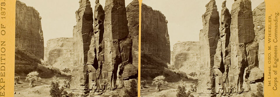
This image is a stereograph taken during the "Expedition of 1873," led by 1st Lieutenant George M. Wheeler of the Corps of Engineers. The photograph depicts a dramatic natural landscape with towering rock formations, likely part of the American Southwest. The rock pillars rise sharply from the ground, surrounded by a dry, rugged terrain scattered with smaller shrubs and trees. The background features massive cliff walls that frame the scene. The stereograph is presented in two nearly identical side-by-side images, designed to create a 3D effect when viewed through a stereoscope. The yellow frame surrounding the photograph identifies the expedition and its leadership.
Created by gpt-4o-2024-08-06 on 2025-06-13
The image is a stereoscopic photograph from 1873 of a striking natural rock formation within a desert canyon landscape. In the foreground, there are several tall, narrow pillars of rock, which are part of a larger cliff formation that rises steeply from the canyon floor. The rocks have a rugged, weathered appearance, indicating the forces of erosion over time. In the background, there are more cliffs with similar textures and formations, and the canyon walls display layers of sedimentary rock.
The base of the canyon is partially visible with some sparse vegetation, including small bushes and trees scattered across the rocky ground. The lighting suggests a clear, sunny day, casting shadows that highlight the verticality and texture of the rock pillars.
Additionally, the card itself contains printed text along the sides. On the left, it states "Expedition of 1873," suggesting that the photograph was taken during a specific exploratory or scientific expedition. On the right, it notes "1st Lieut. Geo. M. Wheeler, Corps of Engineers Commanding," indicating that the work is associated with George M. Wheeler's surveying and mapping expeditions in the 19th century. These expeditions aimed to document and map the American West.
Anthropic Claude
Created by anthropic.claude-3-haiku-20240307-v1:0 on 2025-06-22
The image shows a dramatic and rugged landscape with towering rock formations. The rock formations have an almost sculptural quality, with distinct shapes and textures. The scene appears to be a desert or arid environment, with sparse vegetation in the foreground. The image is presented in a stereoscopic format, with two slightly offset views to create a three-dimensional effect when viewed through a stereoscope.
Created by us.anthropic.claude-3-5-sonnet-20241022-v2:0 on 2025-06-22
This is a historical black and white photograph from 1873 showing impressive rock formations, likely in the American Southwest. The image shows tall, vertical sandstone cliffs or spires rising dramatically from the desert floor. The rock formations appear to be part of a canyon wall, with distinct columnar features carved by natural erosion. There's some vegetation, probably shrubs and small trees, visible at the base of the cliffs. The photograph appears to be mounted on a yellow or cream-colored card with text on the side indicating it's from an "Expedition of 1873" and was taken by what appears to be a geological or engineering corps. The composition captures the impressive scale and natural architecture of these rock formations, which are characteristic of the American Southwest's desert landscape.
Meta Llama
Created by us.meta.llama3-2-11b-instruct-v1:0 on 2025-06-10
The image is a stereoscopic photograph of a canyon landscape, featuring towering rock formations and a desert-like environment.
- The photograph is presented in two halves, with the left half showing the left side of the canyon and the right half showing the right side.
- The left half of the photograph shows a large rock formation in the center, with several smaller rock formations to the left and right.
- In the foreground, there are some bushes and trees scattered throughout the desert landscape.
- The sky above is clear and bright, with no clouds visible.
- The right half of the photograph shows a similar view of the canyon, with the same large rock formation in the center and smaller rock formations to the left and right.
- The foreground of this half of the photograph also features bushes and trees, as well as a few people standing in the distance.
- The sky above is again clear and bright, with no clouds visible.
- The photograph is mounted on a yellow card with rounded corners, which has the words "EXPEDITION OF 1873" printed vertically along the left edge and "1st Lieut. GEO. M. WHEELER, Corps of Engineers Commanding" printed vertically along the right edge.
- The card also has a small number "65" printed in the bottom-right corner.
Overall, the photograph provides a detailed and immersive view of the canyon landscape, with its towering rock formations and desert-like environment. The inclusion of people in the foreground adds a sense of scale and context to the image.
Created by us.meta.llama3-2-90b-instruct-v1:0 on 2025-06-10
The image is a sepia-toned stereoscopic photograph of a desert landscape with tall rock formations. The photograph is divided into two identical halves, each showing the same scene from a slightly different angle, which would have been viewed through a stereoscope to create a 3D effect.
In the foreground, there are several small bushes and trees scattered across the sandy ground. In the background, there are several tall rock formations that rise up from the ground, some of which have flat tops. The sky above is clear and bright.
On the left side of the image, there is text that reads "EXPEDITION OF 1873." On the right side, there is text that reads "1st Lieut. GEO. M. WHEELER, Corps of Engineers Commanding." The overall atmosphere of the image suggests a hot and dry desert environment, with the rock formations providing a sense of grandeur and scale.
Amazon Nova
Created by amazon.nova-lite-v1:0 on 2025-06-06
The image is a black-and-white photograph of a landscape featuring a series of towering rock formations. The photograph appears to be a stereoscopic image, as it is divided into two sections, creating a three-dimensional effect when viewed through a stereoscope. The image is labeled "EXPEDITION OF 1873" and "1st Lieut. GEO. M. WEELER, Corps of Engineers Commanding," indicating that it was taken during an expedition in 1873 led by Lieutenant George M. Wheeler of the U.S. Army Corps of Engineers. The photograph captures a rugged and arid landscape, with the rock formations rising prominently from the ground. The image is a historical record of a landscape that has likely changed over time due to natural processes and human activity.
Created by amazon.nova-pro-v1:0 on 2025-06-06
The image is a stereoscopic photograph, which means it is designed to create a three-dimensional effect when viewed through a stereoscope. It depicts a rugged, arid landscape with prominent rock formations. The photograph is split into two identical halves, each showing a slightly different angle to enhance the 3D effect.
In the foreground, there are sparse patches of vegetation, including small bushes and grasses, indicating a dry environment. The central focus of the image is a series of tall, vertical rock pillars, which rise dramatically from the ground. These rock formations are rugged and jagged, with deep crevices and uneven surfaces, suggesting they are made of hard, resistant rock.
In the background, the landscape extends into a valley or canyon, with more rock formations and a few patches of vegetation. The sky is clear, and the overall lighting suggests it was taken during daylight hours, possibly in the late afternoon given the long shadows cast by the rock formations.
The photograph is framed with a yellow border, and there are inscriptions on the left and right sides. The left side reads "EXPEDITION OF 1873," indicating the year the photograph was taken. The right side lists "1st Lieut. GEO. M. WEELER, Corps of Engineers Commanding," suggesting the person in charge of the expedition during which the photograph was taken.
This image likely captures a moment from a scientific or exploratory expedition, given the detailed inscription and the focus on natural geological features. The use of stereoscopic photography would have been a way to document and share the three-dimensional nature of the landscape with others who were not present.
Google Gemini
Created by gemini-2.0-flash on 2025-05-08
The image is a stereoscopic photograph, presented on a yellow card, featuring a landscape with striking rock formations. The photograph is split into two nearly identical halves, meant to be viewed together to create a 3D effect. The landscape includes tall, eroded rock pillars or towers that dominate the scene, appearing to be made of layered sedimentary rock.
These pillars are situated in a valley, with larger cliffs or canyon walls rising in the background, indicating a canyon or gorge setting. There's a mix of vegetation in the foreground, including small trees and shrubs, suggesting a sparse desert environment. The sky is light and appears overcast, contributing to the soft, sepia-toned quality of the photograph.
The card itself has text indicating that the image is from the "Expedition of 1873" and was taken under the command of "1st Lieut. GEO. M. WHEELER, Corps of Engineers Commanding." This suggests the photo was part of a government or military survey or exploration of the area.
Created by gemini-2.0-flash-lite on 2025-05-08
This is a stereoscopic photograph from the 1873 Expedition led by 1st Lieutenant George M. Wheeler of the Corps of Engineers. The photograph depicts a landscape with prominent rock formations, possibly a canyon or desert environment.
Here's a breakdown:
- Subject: The primary focus is on a cluster of tall, vertical rock formations, appearing as pillars or mesas. They dominate the center of the image.
- Setting: The surrounding environment appears to be a canyon or a similar geological feature. The landscape is arid, with sparse vegetation.
- Composition: The image is split into two side-by-side views, typical of stereoscopic photographs. This creates a three-dimensional effect when viewed through a stereoscope.
- Color: The photograph is in sepia tones, indicating it's a historical image.
- Text: The text identifies the expedition and the person in charge.
Overall, the image is a record of exploration from the 1870s, capturing the grandeur of a natural landscape.
Mistral Pixtral
Created by us.mistral.pixtral-large-2502-v1:0 on 2025-06-03
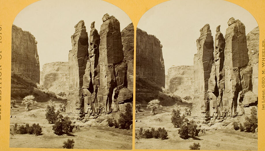
The image is a vintage stereoscopic photograph from 1878, depicting a rugged, desert landscape with tall, narrow rock formations. The photograph is labeled "Expedition of 1878" on the left side and "1st Lieut. Geo. M. Wheeler, Corps of Engineers Commanding" on the right side. The scene shows a series of vertical rock spires or pillars, which appear to be naturally formed through erosion, standing in a desert environment with sparse vegetation, including some small bushes and shrubs. The background features large, rugged cliffs, adding to the dramatic and stark nature of the landscape. The photograph is in sepia tones, characteristic of early photographic techniques.
Qwen
Created by Qwen/Qwen2.5-VL-7B-Instruct on 2025-07-14
This image is a stereoscopic view, which was a popular method of creating the illusion of depth and three-dimensionality in photographs before the advent of modern 3D technology. The photo appears to be part of an expedition from the year 1873, as indicated by the text on the left and right sides of the image. The expedition is attributed to the "1st Lieut. Geo. M. Wheeler, Corps of Engineers Commanding."
The photograph captures a dramatic landscape featuring tall, narrow rock formations, likely part of a canyon or desert region. The terrain is arid, with sparse vegetation, including small trees and bushes. The rock formations have a rough, textured surface, and the scene is bathed in sunlight, casting shadows that further enhance the three-dimensional effect of the stereoscopic view. The overall impression is one of grand natural beauty and ruggedness.
Created by Qwen/Qwen2.5-VL-72B-Instruct on 2025-07-14
This is a stereoscopic photograph, a type of image designed to create a 3D effect when viewed with a stereoscope. The image shows a dramatic landscape featuring towering rock formations in a canyon-like setting. The rock formations are tall and appear to be made of layered sedimentary rock, with some erosion visible. There is sparse vegetation, including a few trees and bushes, scattered across the foreground. The sky is clear, suggesting a sunny day. The text on the left side of the image reads "EXPEDITION OF 1873," and the text on the right side reads "1st Lieut. Geo. M. Wheeler, Corps of Engineers Commanding." This indicates that the photograph is from an expedition led by Lieutenant George M. Wheeler in 1873.
Text analysis
Amazon