Machine Generated Data
Tags
Color Analysis
Feature analysis
Amazon
Clarifai

Clarifai
| Computer monitor | 44.4% | |
Categories
Imagga
created on 2019-06-07
| text visuals | 99.8% | |
Captions
Microsoft
created by unknown on 2019-06-07
| a close up of a piece of paper | 78.1% | |
| a piece of paper | 77.1% | |
| close up of a piece of paper | 75.9% | |
Salesforce
Created by general-english-image-caption-blip-2 on 2025-07-05
a sheet of paper with a number on it
Created by general-english-image-caption-blip on 2025-06-13
a photograph of a paper with a checkered checkered checkered checkered checkered checkered
OpenAI GPT
Created by gpt-4o-2024-11-20 on 2025-06-14
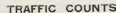
This image features a document titled “Traffic Counts” related to city planning. The document is a blank form meant to record traffic-related data for investigation purposes. It includes sections for borough, street, and the area being studied. There are details for measuring the width of the street, roadway, and sidewalk.
The main table is divided into categories, tracking data for vehicles and pedestrians. The vehicle section lists different types of vehicles (light horse-drawn, heavy horse-drawn, automobiles, streetcars, motor trucks, etc.), while the pedestrian section accounts for pedestrians, noting their transit status (male, female, children). The table is aligned with rows for date, hours, and direction of movement (represented with left and right arrow symbols). A "Remarks" column is also included for additional notes.
Overall, it is a detailed urban planning tool used to analyze and monitor traffic and pedestrian flow for infrastructure and city development studies.
Created by gpt-4o-2024-08-06 on 2025-06-14
The image is a scan of a document titled "City Planning, Schedules Used in Investigation." It is a traffic count sheet used for city planning purposes. The document is laid out as a grid formatted for collecting data on vehicular and pedestrian traffic.
At the top of the form, there are fields to fill in information such as "Borough," "Street," and "Between" (specific intersections), as well as measurements for "Width of Street," "Clear Width of Roadway," and "Clear Width of Sidewalk."
Below this header, the grid is organized into columns for various types of information. The columns are labeled for recording the date, specific times, and directions of traffic. There are additional columns for different types of vehicles, including "Light Horse," "Heavy Horse," "Autobusses," "Autocabs," "Street Cars," and "Motor Vehicles," with subcategories and check boxes for tracking different types of vehicles. Pedestrian traffic can also be recorded, with sections labeled "Pedestrians," including "Total Number," "Women," "Men," and "Children."
Each row can be used to document traffic during different time intervals for one direction of traffic. There is a "Remarks" column on the far right of the grid for any additional notes. The sheet includes a series of grid lines to organize the information clearly, and the entire layout allows for systematic data collection for traffic studies.
Anthropic Claude
Created by anthropic.claude-3-haiku-20240307-v1:0 on 2025-06-20
The image appears to be a traffic count sheet used for city planning purposes. It contains a grid with various columns for recording different types of vehicles and pedestrians passing through a specific street or intersection. The grid has rows for different time periods, allowing for detailed tracking of traffic patterns and volumes. The title "Traffic Counts" at the top of the sheet indicates this is a document used to gather data on the flow of traffic in a particular area.
Created by us.anthropic.claude-3-5-sonnet-20241022-v2:0 on 2025-06-20
This image shows a blank traffic count form used for city planning purposes. The form has several sections for recording different types of data:
At the top, there are fields for:
- Borough
- Street
- Between (cross streets)
- Pavement details
- Width of street
- Clear width of roadway
- Clear width of sidewalk
The main grid portion of the form is divided into columns for recording:
- Date/time
- Direction (shown with arrows)
- Different vehicle types (light, heavy, buses, etc.)
- Pedestrian counts
- Bicycles
The form appears to be unused, with empty rows ready for data collection. It's printed on white paper with blue grid lines. The title "TRAFFIC COUNTS" appears prominently at the top of the form. This type of form would typically be used by city planners or traffic engineers to collect data about traffic patterns and volume at specific locations.
Meta Llama
Created by us.meta.llama3-2-11b-instruct-v1:0 on 2025-06-13
The image displays a table titled "Traffic Counts" with a grid layout, likely used for data collection and analysis in the field of urban planning or transportation.
- The table has the following columns:
- Borough
- Street
- Date
- Time
- Vehicles
- Cars
- Trucks
- Buses
- Motorcycles
- Pedestrians
- Bicycles
- The table appears to be a template for collecting traffic data, with blank spaces for the user to fill in the relevant information.
- The table is set against a beige background, which provides a neutral and professional backdrop for the data collection process.
Overall, the image suggests that the table is a tool for collecting and organizing data on traffic patterns and volumes, which can be used to inform urban planning decisions and improve traffic flow.
Created by us.meta.llama3-2-90b-instruct-v1:0 on 2025-06-13
The image depicts a city planning document titled "City Planning: Schedules Used in Investigation" at the top, with the main focus being a table labeled "TRAFFIC COUNTS." The table features columns for "BOROUGH," "STREET," and "VEHICLES," accompanied by rows representing different types of vehicles. The table is designed to track traffic counts, with arrows indicating the direction of traffic flow.
The background of the image is a light beige color, providing a clean and neutral backdrop for the table. Overall, the image appears to be a historical document related to urban planning and traffic management, likely used to analyze and understand traffic patterns in a specific city or region.
Amazon Nova
Created by amazon.nova-lite-v1:0 on 2025-06-14
The image appears to be a document titled "Traffic Counts" used for city planning and investigation purposes. It contains a table with various categories and columns, possibly for recording traffic data. The table includes columns for "Vehicles," "Pedestrians," "Date," "Time," "Speed," "Width of Street," "Clear Width of Roadway," and "Clear Width of Sidewalk." The table is filled with numerical values and arrows, indicating different types of traffic counts. The document is displayed on a gray background, and the text is written in black font. The image provides a snapshot of the traffic data collected for city planning and investigation purposes.
Created by amazon.nova-pro-v1:0 on 2025-06-14
The image shows a traffic count sheet, which is a document used for recording traffic data. The sheet is organized into sections and columns, with headings such as "Traffic Counts," "Vehicles," "Pedestrians," and "Grades." The sheet has a grid-like structure with rows and columns, and there are arrows pointing in different directions, indicating the flow of traffic. The sheet appears to be blank, with no data entered, and is likely used for recording traffic data during an investigation or study.
Google Gemini
Created by gemini-2.0-flash on 2025-06-13
Here is a description of the image:
The image shows a document titled "Traffic Counts" used in City Planning Investigations. It appears to be a scheduling form or data collection sheet with rows and columns for recording information about traffic on a specific street. The document has categories for borough, street, location, width of street, width of roadway, width of sidewalk, dates, weather, temperature, and density. There are also several categories for vehicles, including light usage, heavy usage, automobiles, autotrucks, streetcars, buses, motorlanders, motorcycles and total usage per foot width of roadway. Finally, the document includes categories for pedestrians and remarks. The rows on the form are blank, with directional arrows to indicate movement. The sheet is light blue with black lettering. The image is set against a gray background.
Created by gemini-2.0-flash-lite on 2025-06-13
The image is of a blank traffic count form used in a city planning investigation. It's a printed document on what appears to be a light grey paper.
Here's a breakdown:
- Title & Purpose: The title at the top reads "TRAFFIC COUNTS" and indicates this is used for collecting traffic data. Below that, there is "City Planning, Schedules Used in Investigation".
- Header Information: There are areas for general details like "BOROUGH", "STREET", "BETWEEN CORNER", "PAVEMENTS", "GRASSES". There are also fields to record "WIDTH OF STREET," "CLEAR WIDTH OF ROADWAY," and "CLEAR WIDTH OF SIDEWALK."
- Data Sections: The main body of the form is a grid intended for data recording.
- Columns: Include information about "DATE", "TIME", "LOCATION OF OBSERVATION", "DIRECTION", "TEMPERATURE/DENSITY", and then the categories "LIGHT LOADS", "HEAVY LOADS", "AUTOMOBILES", "AUTOPICKUPS", "STREET CARS", "WAGON LOADERS" for vehicles and for "PEDESTRIANS". Finally, it has a column labeled "REMARKS"
- Rows: The rows are for entering the data collected for specific time intervals.
- Arrows: There are arrows in the form to indicate traffic direction.
- Overall Impression: The overall design is simple, with a focus on structured data collection. It's a classic example of a pre-computer-era form.
Mistral Pixtral
Created by us.mistral.pixtral-large-2502-v1:0 on 2025-06-13
The image is a form titled "TRAFFIC COUNTS," which appears to be used for recording traffic data as part of city planning investigations. The form is divided into several sections for recording specific information:
- Borough: A space to indicate the borough where the traffic count is being conducted.
- Street: A space to specify the street being observed.
- Direction: A space to note the direction of the traffic being counted.
- Width of Street: A section to record the width of the street.
- Clear Width of Sidewalk: A section to note the clear width of the sidewalk.
- Planimetric Date: A space to record the date of the planimetric survey.
- Observer: A space for the name of the observer conducting the traffic count.
The main section of the form is a table with columns for recording various types of vehicles and pedestrians. The columns are labeled as follows:
- Time Period: The time intervals for recording traffic data (e.g., 7:00-7:15, 7:15-7:30).
- Vehicles: Different types of vehicles are listed, including:
- Passenger Cars
- Light Trucks
- Heavy Trucks
- Motorcycles
- Bicycles
- Other Vehicles
- Pedestrians: Columns to record the number of pedestrians in different categories:
- Adults
- Children
- Total
The table is designed to record the number of each type of vehicle and pedestrian observed during each time interval. The form is structured to provide a comprehensive overview of traffic patterns and pedestrian activity over a specified period.
Qwen
Text analysis
Amazon