Machine Generated Data
Tags
Color Analysis
Feature analysis
Amazon
Clarifai

Clarifai
| Envelope | 38.2% | |
Categories
Imagga
created on 2019-06-04
| text visuals | 99.6% | |
Captions
Microsoft
created by unknown on 2019-06-04
| a close up of a sign | 64.4% | |
| close up of a sign | 58.5% | |
| a sign on a wall | 42.9% | |
Clarifai
No captions written
Salesforce
Created by general-english-image-caption-blip-2 on 2025-07-07
a map of new york city and its surrounding areas
Created by general-english-image-caption-blip on 2025-05-04
a photograph of a map of a map of a city
OpenAI GPT
Created by gpt-4o-2024-11-20 on 2025-06-09
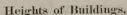
The image features two maps related to building coverage in Manhattan and Brooklyn. The maps are printed on a beige background and titled "Heights of Buildings."
Left Map: A horizontal, detailed illustration depicting Manhattan. It shows the prevailing percentages of lot areas covered by buildings, with sections labeled and shaded to represent different levels of coverage. The accompanying caption reads: "Prevailing percentage of lot area covered by building in Manhattan. Numbers indicate percentage covered. (Source: Report of Heights of Buildings Commission...New York, 1913, p.65)."
Right Map: A vertical map depicting Brooklyn with similar detailing. It also illustrates prevailing percentages of lot areas covered by buildings using shading and labels to indicate percentages. The caption states: "Prevailing percentage of lot areas covered by building in Brooklyn. Numbers indicate percentage covered. (Source: Report of Heights of Buildings Commission...New York, 1913, p.69)."
Both maps focus on urban planning details about building space relative to lot coverage during the early 20th century, offering visual context for the commission's findings.
Created by gpt-4o-2024-08-06 on 2025-06-09
The image consists of a beige background with two detailed black and white maps positioned side by side. Both maps illustrate areas within New York City and are accompanied by text descriptions.
On the left, there is a map of Manhattan displaying various areas and streets, noted for showing the prevailing percentage of lot area covered by buildings. Below the map, a label states: "Prevailing percentage of lot area covered by building in Manhattan. Numbers indicate percentage covered. (Source: Report of Heights of Buildings Commission...New York, 1913, p.63)."
On the right, there's a map of Brooklyn which similarly details the percentage of lot area covered by buildings throughout the borough. Below this map, a label reads: "Prevailing percentage of lot area covered by building in Brooklyn. Numbers indicate percentage covered. (Source: Report of Heights of Buildings Commission...New York, 1913, p.69)."
At the top center of the beige background is the title "Heights of Buildings," indicating the general theme of the maps—building coverage in relation to height regulations or planning during the early 20th century in New York City.
Anthropic Claude
Created by anthropic.claude-3-haiku-20240307-v1:0 on 2025-06-13
This image appears to be a collection of maps and data related to the heights of buildings. The main part of the image shows a panoramic view of a cityscape, with a caption indicating that this represents the "Prevailing percentages of 1st area covered by buildings in Brooklyn". Below this, there is a smaller map that also shows the "Prevailing percentages of 1st area covered by buildings" in a different location, likely another part of the city. The image provides quantitative data about the percentage of land area covered by buildings in these urban areas.
Created by us.anthropic.claude-3-opus-20240229-v1:0 on 2025-06-13
The image shows two black and white maps titled "Heights of Buildings". The map on the left depicts an area with many rectangular shapes, likely representing buildings, with varying levels of shading or hatching, presumably indicating the heights of those buildings. The map on the right shows a similar area but with more dense shading or hatching, suggesting it represents building heights at a different point in time, likely showing increased building density or height compared to the map on the left. The captions below the maps provide more context, mentioning "prevailing percentages of lot area covered by buildings" for different time periods in the early 20th century.
Created by us.anthropic.claude-3-5-sonnet-20241022-v2:0 on 2025-06-13
This image shows two maps related to "Heights of Buildings" as indicated by the title at the top. The maps appear to be historical documents showing urban layouts. The left map is elongated and horizontal in shape, while the right map appears to be more square in format. Both maps have captions below them referencing "Prevailing percentage of lot area covered by building" in what appears to be New York, dated 1913. The maps show street grids and building footprints or lot coverage patterns in what seems to be different parts of Manhattan or Brooklyn. The images are presented on what looks like a light gray or beige background, and the maps themselves appear to be black and white or grayscale.
Meta Llama
Created by us.meta.llama3-2-11b-instruct-v1:0 on 2025-05-29
The image displays a page from an old book or document, featuring two maps of New York City.
At the top of the page, the title "Heights of Buildings" is written in black text on a white background. Below the title, there are two maps side by side. The left map is a long, narrow rectangle, while the right map is a square with a star in the upper-right corner. Both maps are in black and white and appear to be hand-drawn. They depict different areas of New York City, with buildings and streets labeled.
Underneath each map, there is a white rectangle with black text that provides information about the map. The text is too small to read clearly, but it appears to be a description of the map and its contents.
The background of the page is a light beige color, which provides a neutral backdrop for the maps and text. Overall, the image suggests that the document is an old book or report about the heights of buildings in New York City, possibly from the early 20th century.
Created by us.meta.llama3-2-90b-instruct-v1:0 on 2025-05-29
The image presents a page from an old book or document, featuring two maps of New York City. The title "Heights of Buildings" is prominently displayed at the top center of the page.
Map 1: Manhattan
The left map depicts the island of Manhattan, showcasing the prevailing percentages of lot area covered by buildings in Manhattan. A white rectangle below the map provides additional information, including the source: Report of Heights of Buildings Commission...New York, 1913, p. 68.
Map 2: Brooklyn
The right map illustrates the borough of Brooklyn, highlighting the prevailing percentages of lot area covered by buildings in Brooklyn. Another white rectangle beneath the map offers supplementary details, including the source: Report of Heights of Buildings Commission...New York, 1913, p. 69.
The background of the page is a light tan color, with a subtle shadow effect around the edges, suggesting that the image may have been scanned from a physical book. Overall, the image appears to be a historical document or report related to urban planning and architecture in New York City.
Amazon Nova
Created by amazon.nova-lite-v1:0 on 2025-05-28
A document with two maps and text. The first map is titled "Heights of Buildings" and is a map of Manhattan, New York. The map shows the heights of buildings in different areas of the city, with the colors indicating the percentage of the area covered by buildings. The second map is titled "Prevailing percentages of lot area covered by building in Brooklyn" and is a map of Brooklyn, New York. The map shows the prevailing percentages of lot area covered by buildings in different areas of the city. The text on the document provides information about the maps and their sources.
Created by amazon.nova-pro-v1:0 on 2025-05-28
The image shows a page with a title "Heights of Buildings" and two maps, one on the left and one on the right, with text on the bottom of each map. The maps are in black and white and show the areas of Manhattan and Brooklyn, respectively, with the buildings marked in different shades of gray. The text on the bottom of each map provides information about the percentage of the area covered by buildings of different heights.
Google Gemini
Created by gemini-2.0-flash on 2025-05-01
Here is a description of the image:
The image is a mounted page with two separate maps and text labels, all related to building heights in New York City. The page itself is a pale gray. At the top, centered, the title "Heights of Buildings," is printed in a simple, dark font.
On the left side of the page, there is a horizontally oriented map, depicting a long, narrow landmass. This appears to be a map of Manhattan. The map shows a grid of streets, with small building footprints indicated. Beneath the map, a typed label reads: "Prevailing percentages of lot area covered by building in Manhattan. Numerals indicate percentage covered. (Source: Report of Heights of Buildings Commission...New York, 1913, p. 68)."
On the right side of the page, there's a vertically oriented map showing a larger, more irregularly shaped landmass. This is likely a map of Brooklyn. The same street grid and building footprint detail is present, with numerals indicating percentages. Below this map, there's a typed label similar to the one on the left: "Prevailing percentages of lot area covered by building in Brooklyn. Numerals indicate percentage covered. (Source: Report of Heights of Buildings Commission...New York, 1913, p. 69)."
The maps and text labels are presumably from a report about building heights and land coverage in New York City from 1913. In the upper right-hand corner of the page, there is a faint marking, possibly a catalog or index number, "64. 111.72.1"
Created by gemini-2.0-flash-lite on 2025-05-01
Here's a description of the image:
Overall Impression:
The image appears to be a page or plate from a historical document, likely a report or study on urban planning and building heights. It features two maps, text annotations, and is presented on a simple, neutral background.
Content:
- Maps: There are two maps within the image. The map on the left looks like Manhattan, New York. The map on the right appears to show Brooklyn, New York. Both maps are detailed and seem to depict the urban layout, streets, and possibly building footprints.
- Text Annotations: Below each map, there are rectangular text boxes providing captions or descriptions. The text seems to explain what the maps illustrate, specifically, it mentions "prevailing percentages of lot area covered by building" and "numerals indicate percentage covered." The text also indicates that the source of the information is a "Report of Heights of Buildings Commission, New York, 1913" and provides the page numbers where the information can be found (p.66 and p.69 respectively).
Style and Tone:
- The image has a historical and somewhat technical feel, given the map style, font, and subject matter.
- The color palette is neutral, with a muted grey background. The maps are in black and white or a similar monochromatic style.
Possible Purpose:
This image was likely created to visually represent data or findings related to building density and heights in New York City, possibly as part of a planning study, architectural analysis, or a discussion on urban development.
Mistral Pixtral
Created by us.mistral.pixtral-large-2502-v1:0 on 2025-06-04
The image depicts two maps illustrating the percentage of lot area covered by buildings in different regions. The title "Heights of Buildings" is at the top center of the image.
Left Map:
- Title: "Prevailing percentages of lot area covered by buildings in localities, New York City, 1916."
- Source: "Report of Heights of Buildings Commission, New York, 1916, p. 108."
- Description: This map shows a linear area, likely a section of New York City, with various shades indicating different percentages of lot area covered by buildings. The map appears to be oriented horizontally and covers a relatively narrow geographic region.
Right Map:
- Title: "Prevailing percentages of lot area covered by buildings in Brooklyn, New York City, 1916."
- Source: "Report of Heights of Buildings Commission, New York, 1916, p. 109."
- Description: This map represents a larger, more spread-out area, specifically Brooklyn. It also uses different shades to denote the percentage of lot area covered by buildings. The map is more detailed and covers a broader geographic region compared to the left map.
Both maps are part of a report from the Heights of Buildings Commission in New York City, dated 1916, and they aim to provide a visual representation of building density in specific areas during that time. The shading likely indicates varying levels of building coverage, with darker shades representing higher percentages of lot area covered by buildings.
Qwen
Created by Qwen/Qwen2.5-VL-7B-Instruct on 2025-07-12
The image appears to be a historical document or report page titled "Heights of Buildings." It features two maps, each showing the coverage percentages of lot area by building in different areas of New York City.
The left map is labeled "Prevailing percentages of lot area covered by building in Manhattan." It provides quantitative data of how much of the lot area in Manhattan is occupied by buildings, based on a source cited as "Report of Heights of Buildings Commission...New York, 1915, p.66."
The right map is labeled "Prevailing percentages of lot area covered by building in Brooklyn." It similarly provides data on the coverage of lot areas by buildings in Brooklyn, with the source cited as the same "Report of Heights of Buildings Commission...New York, 1915, p.66."
The maps are detailed and detailed, with grid lines and labeled areas, suggesting a focus on urban land use and building density. The style of the maps and the citation suggest that this document is from the early 20th century, likely around 1915, and it is part of a report that examines the urban landscape and building regulations of the time.
Created by Qwen/Qwen2.5-VL-72B-Instruct on 2025-07-12
This image shows a page from a document or report that discusses the "Heights of Buildings." The page contains two maps and accompanying text descriptions.
Left Map: This map appears to represent Manhattan. Below the map, there is a caption that reads:
- "Prevailing percentages of lot area covered by building in Manhattan. Numerals indicate percentages covered. [Source: Report of Heights of Buildings Commission...New York, 1913, p. 66.]"
Right Map: This map appears to represent Brooklyn. Below the map, there is a caption that reads:
- "Prevailing percentages of lot area covered by building in Brooklyn. Numerals indicate percentages covered. [Source: Report of Heights of Buildings Commission...New York, 1913, p. 66.]"
Both maps seem to illustrate the coverage of building lots in Manhattan and Brooklyn, with numerical indicators showing the percentage of lot area covered by buildings. The source for both maps is cited as the Report of Heights of Buildings Commission, New York, 1913, page 66.
Text analysis
Amazon