Machine Generated Data
Tags
Color Analysis
Feature analysis
Amazon
Clarifai
AWS Rekognition
| Airplane | 70% | |


Categories
Imagga
created on 2019-06-07
| text visuals | 70.3% | |
| paintings art | 29.5% | |
Captions
Microsoft
created by unknown on 2019-06-07
| a close up of a piece of paper | 64.1% | |
| close up of a piece of paper | 61.6% | |
| a piece of paper | 61.5% | |
Clarifai
No captions written
Salesforce
Created by general-english-image-caption-blip on 2025-06-13
a photograph of a map of the city of ottawa, canada
Created by general-english-image-caption-blip-2 on 2025-07-06
a map of the city of paris, with four different maps
OpenAI GPT
Created by gpt-4o-2024-11-20 on 2025-06-14
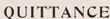
The image is a historical document related to improved workmen's dwellings in France, with the title "Improved Workmen's Dwellings: France" displayed at the top. It consists of four distinct sections:
Top Left: A form titled "QUITTANCE DE LOYER" (Rent Receipt) issued by the "Société Civile des Maisons Ouvrières" (Civil Society for Workers' Housing). The receipt includes details about rent payments for affordable housing constructed by the society, alongside a note emphasizing the use of rent funds for constructing new low-cost housing.
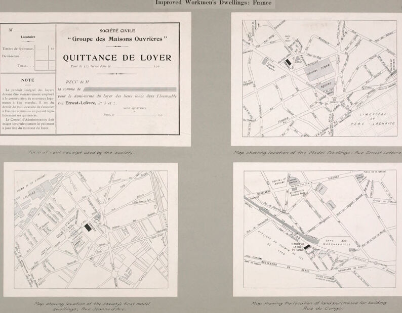
Top Right: A detailed map showing the location of the model dwellings on Rue Ernest Lefèvre, with streets marked and notable landmarks such as "Cimetière du Père Lachaise" (Père Lachaise Cemetery) and "Hospital Tenon" visible on the map.
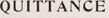
Bottom Left: Another map displaying the location of the society's first model dwellings, specifically on Rue Jeanne d'Arc. Streets and facilities in the area are labeled.
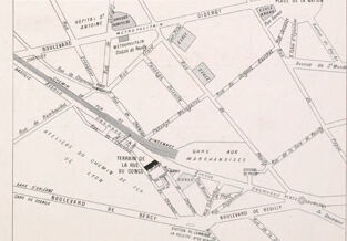
Bottom Right: A map illustrating the location of land purchased for building on Rue du Congo. This map highlights streets and other landmarks, with specific attention to the purchased area labeled "Terrain de la Ru du Congo."
The gray background frames the document, and descriptive captions under each section provide further context. This image documents efforts to create affordable housing for workers in early 20th-century France.
Created by gpt-4o-2024-08-06 on 2025-06-14
The image is a historical document titled "Improved Workmen's Dwellings: France." It consists of four separate sections placed on a single sheet.
The top left section features a rent receipt form used by the "SOCIÉTÉ CIVILE 'Groupe des Maisons Ouvrières'." The receipt is titled "QUITTANCE DE LOYER" and includes fields for the date, amount, and location. It notes that rental payments are used strictly for the construction of affordable housing.
The top right section is a map showing the location of the Model Dwellings at Rue Ernest Lefèvre. The map illustrates the streets and local landmarks surrounding the area.
The bottom left section presents a map indicating the location of the society's first model dwellings at Rue Jeanne d'Arc. It highlights streets and areas in proximity to these dwellings.
The bottom right section is another map that displays the location of the land purchased for building on Rue du Congo. This map also outlines the streets surrounding the area.
Each map provides context for the urban planning and development efforts in France related to workers' housing. The maps are labeled with annotations explaining their respective focus within the planning project.
Anthropic Claude
Created by anthropic.claude-3-haiku-20240307-v1:0 on 2025-06-20
The image appears to be a collection of documents related to "Improved Workmen's Dwellings" in France. It includes a rental receipt form used by the "Groupe des Maisons Ouvrieres" (Workers' Homes Group) society, as well as several maps showing the locations of the model dwellings on Rue Ernest Lefèvre and Rue du Congo. The maps provide detailed street layouts and indicate the areas where these improved workmen's dwellings were constructed.
Created by us.anthropic.claude-3-5-sonnet-20241022-v2:0 on 2025-06-20
This image appears to be a historical document showing four different items related to workmen's dwellings in France:
Top left: A rent receipt form ("Quittance de Loyer") from the "Société Civile Groupe des Maisons Ouvrières" (Civil Society Group of Workers' Houses). The form includes spaces for tenant information and rent payment details, with a note about the proper use of rental income.
Top right: A map showing the location of model dwellings on Rue Ernest-Lefèvre.
Bottom left: A map showing the location of the society's first model dwellings on Rue Jeanne d'Arc.
Bottom right: A map showing the location of land purchased for building on Rue de Congo.
All three maps appear to be street plans of different areas in Paris, with the relevant properties marked in black. The document seems to be part of a larger presentation or report about improved housing for workers in France, as indicated by the title at the top of the page "Improved Workmen's Dwellings: France."
Meta Llama
Created by us.meta.llama3-2-11b-instruct-v1:0 on 2025-06-13
The image is a page from a book or document titled "Improved Workmen's Dwellings: France." The page features four maps of different locations in France, each with a key and labels indicating the location of various buildings and streets.
- The top-left map is labeled "Société Civile 'Groupe des Maisons Ouvrieres'" and appears to be a key or index for the other three maps.
- The top-right map shows a location in Paris, with several buildings and streets labeled, including the "Quittance de Lover" and the "Rue Ernest Lefèvre."
- The bottom-left map also appears to be in Paris, with several buildings and streets labeled, including the "Rue Jerome d'Aire" and the "Rue de la Croix."
- The bottom-right map shows a location in another city, with several buildings and streets labeled, including the "Rue de la Croix" and the "Rue de la République."
Overall, the page appears to be a collection of maps showing the locations of improved workmen's dwellings in France, with each map providing more detailed information about the specific location and its surroundings.
Created by us.meta.llama3-2-90b-instruct-v1:0 on 2025-06-13
This image depicts a page from an old book or document, featuring four maps and a title that reads "Improved Workmen's Dwellings: France." The maps are arranged in two rows of two, with the top-left map being a key to the others. The key is titled "Société Civile 'Groupe des Maisons Ouvrières' Quittance de Loyer" and includes a note in French.
The remaining three maps appear to be hand-drawn and show the location of buildings in relation to streets and other landmarks. The maps are labeled as follows:
- Top-right: "Map showing location of the Model Dwellings - Rue Ernest Lefevre"
- Bottom-left: "Map showing location of the society's first model dwellings - Rue Jeanne d'Arc"
- Bottom-right: "Map showing the location of land purchased for building - Rue du Cortga"
The background of the page is a light gray color, and the text and maps are printed in black ink. Overall, the image suggests that it is part of a historical document or book related to housing or urban planning in France.
Amazon Nova
Created by amazon.nova-lite-v1:0 on 2025-06-14
The image is a document that is part of the "Improved Workmen's Dwellings: France" collection. It is a receipt form used by the "Societe Civile Groupe des Maisons Ouvriere" for tenants of their housing. The receipt form is titled "QUITTANCE DE LOYER" and is dated 190. The form includes sections for the tenant's name, address, and the amount of rent paid. There are also maps showing the location of the society's first model dwellings and the location of land purchased for building. The document is printed in French and includes a note stating that the rent is paid on the first of the month.
Created by amazon.nova-pro-v1:0 on 2025-06-14
The image shows a gray background with four maps of Paris and some text. The maps are in black and white, and they show the locations of various buildings and streets in Paris. The text on the maps includes the names of the streets and buildings, as well as some additional information about the locations. The text on the gray background includes the title "Improved Workmen's Dwellings: France" and some additional information about the maps and the locations they depict.
Google Gemini
Created by gemini-2.0-flash on 2025-04-29
Here's a description of the image:
The image presents a collection of illustrations and documents related to "Improved Workmen's Dwellings" in France. It seems to be a display or presentation of information.
Here's a breakdown of the four main elements:
Rent Receipt Form: A printed form titled "Quittance de Loyer" (Rent Receipt). It includes spaces for the tenant's name, amounts paid, and a note specifying payment terms and council responsibilities. It's labeled as the "Form of rent receipt used by the society."
Map 1: A street map highlighting the location of the "Model Dwellings" on Rue Ernest Lefèvre. A specific building or area is marked, indicating its relevance.
Map 2: Similar to Map 1, this map focuses on the location of the "society's first model dwellings" on Rue Jeanne d'Arc, with a highlighted area indicating the buildings.
Map 3: A map displaying the location of land purchased for building on Rue du Congo, with a marked area indicating the specific plot.
Overall Impression:
The image appears to be a historical document or a reproduction of one, likely from a report or presentation. It offers insights into the planning and execution of housing projects for workers in France, showing not only the financial aspects (rent receipts) but also the geographical locations of the dwellings and land acquisitions. The stark black and white presentation, coupled with the formal lettering and map styles, gives it a vintage feel.
Created by gemini-2.0-flash-lite on 2025-04-29
Here's a description of the image:
The image is a composite of four different illustrations related to "Improved Workmen's Dwellings" in France. It's laid out on a grey background.
Top Left: A form. It's labeled "QUITTANCE DE LOYER" (Rent Receipt) from a group called "Groupe des Maisons Ouvrières" (Workers' Housing Group). It has spaces for rent details and a note about the procedures for rent payments.
Top Right: A map titled "Map showing location of the Model Dwellings: Rue Ernest Lefèvre". The map is of a city street layout with the model dwellings marked in black.
Bottom Left: A map titled "Map showing location of the society's first model dwellings, Rue Jeanne d'Arc". The map features a street layout with the model dwellings marked in black.
Bottom Right: A map titled "Map showing the location of land purchased for building Rue du Congo." It shows a street layout with the location of the purchased land identified in black.
The overall style of the illustrations is in black and white, with a detailed, architectural-drawing aesthetic, possibly from the late 19th or early 20th century. The text is predominantly French.
Mistral Pixtral
Created by us.mistral.pixtral-large-2502-v1:0 on 2025-06-14
The image is a historical document titled "Improved Workmen's Dwellings: France." It appears to be a collection of materials related to a housing project for workers in France, specifically focusing on the "Société Civile 'Groupe des Maisons Ouvrières'" and their "Quittance de Loyer" (Rent Receipt).
Top Left Section:
- This section contains a rent receipt used by the society. The receipt is titled "Quittance de Loyer" and includes details such as the amount of rent paid, the period covered, and the signature of the recipient. The receipt is from the "Société Civile 'Groupe des Maisons Ouvrières'" and is addressed to Ernest Lefebvre.
Top Right Section:
- This section features a map showing the location of the "Model Dwellings" on Rue Ernest Lefebvre. The map highlights the specific area where these improved workmen's dwellings are situated.
Bottom Left Section:
- This section includes a map showing the location of the society's first model dwelling on Boulevard de l'Hôpital. The map provides a detailed view of the surrounding area, indicating the exact position of the dwelling.
Bottom Right Section:
- This section contains a map showing the location of land purchased for building on Rue de la Glacière. The map highlights the specific plot of land designated for the construction of new dwellings.
Overall, the document provides a detailed overview of the locations and administrative aspects of improved workmen's dwellings in France, likely aimed at enhancing living conditions for workers.
Qwen
Created by Qwen/Qwen2.5-VL-7B-Instruct on 2025-07-06
The image is a historical document related to the "Groupe des Maisons Ouvrières" (Group of Worker's Houses) in France. It includes four parts:
Top Left: A rent receipt from the society. It is titled "Société Civile 'Groupe des Maisons Ouvrières' - Quittance de Loyer" and indicates it is a receipt for the half-term rent due on January 190. The receipt mentions that the rent money will be used for the construction of new, affordable housing. The text is in French.
Top Right: A map showing the location of the "Model Dwellings" on Rue Ernest Lefèvre in Paris.
Bottom Left: Another map showing the location of the society's first model dwellings on Rue Jeanne d'Arc.
Bottom Right: A map showing the location of land purchased for building the "Rue du Congo."
The document appears to be part of a report or archive related to the construction and management of affordable housing for workers in France during the early 20th century.
Created by Qwen/Qwen2.5-VL-72B-Instruct on 2025-07-06
The image is a historical document related to improved workmen's dwellings in France. It is divided into four sections:
Top Left Section: This section contains a form titled "QUITTANCE DE LOYER" (Rent Receipt) from the "SOCIÉTÉ CIVILE 'Groupe des Maisons Ouvrières'" (Civil Society 'Group of Workers' Houses'). The form is for receiving rent payments for the half-term due. It includes fields for the tenant's name, date, amount paid, and notes about the use of the collected rent for the construction of new housing. The specific address mentioned is "rue Ernest-Lefèvre, n°5 et 7."
Top Right Section: This is a map showing the location of the model dwellings on "Rue Ernest Lefèvre." The map includes surrounding streets and landmarks, such as the "Hôpital Tenon" and the "Cimetière du Père-Lachaise."
Bottom Left Section: This map shows the location of the society's first model dwellings on "Rue Jeanne d'Arc." It includes various street names and landmarks in the vicinity.
Bottom Right Section: This map shows the location of land purchased for building on "Rue du Congo." It includes detailed street names and landmarks, such as the "Gare d'Orléans" and the "Boulevard de Bercy."
The document is labeled at the top as "Improved Workmen's Dwellings: France" and includes a reference number "G Ho.439. 231. 30.11." Each map is labeled with a description of its contents.
Text analysis
Amazon