Machine Generated Data
Tags
Color Analysis
Feature analysis
Amazon
Clarifai

Clarifai
| Picture frame | 61% | |

Categories
Imagga
created on 2019-06-06
| paintings art | 54.5% | |
| text visuals | 45.5% | |
Captions
Microsoft
created by unknown on 2019-06-06
| a close up of a map | 62.4% | |
| close up of a map | 57.9% | |
| a map with text | 44.7% | |
Clarifai
No captions written
Salesforce
Created by general-english-image-caption-blip on 2025-05-20
a photograph of a map of a map of a map of a city
Created by general-english-image-caption-blip-2 on 2025-07-06
a map of the town of new haven, new hampshire
OpenAI GPT
Created by gpt-4o-2024-11-20 on 2025-06-09
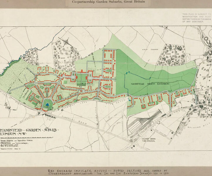
The image depicts an architectural map of Hampstead Garden Suburb in London, NW. It is a planned residential area designed with green spaces and detailed layouts. The map features houses outlined in red and open spaces shaded in green. The legend at the bottom explains that the red squares indicate houses owned by the Co-partnership Association in Hampstead as of 1910.
On the map, Hampstead Heath Extension is prominently labeled and shaded green to represent the protected open area. Streets are labeled with a detailed street network, and there's a golf course marked nearby, suggesting the suburban layout includes recreational spaces. Other areas, including Golden Green Tube Station and surrounding neighborhoods, are indicated in black and white.
Created by gpt-4o-2024-08-06 on 2025-06-09
The image is an architectural plan or map of the Hampstead Garden Suburb located in London N.W., labeled as part of the "Co-partnership Garden Suburbs, Great Britain". The map is detailed, displaying streets, lots, and parcels of land. Green shading is used to identify areas designated for gardens or open spaces, and red shading indicates housing or built-up plots.
The suburb is bordered by several landmarks, including the "Hampstead Heath Extension" prominently marked in green on the right side of the image, and extending to the "Hampstead Heath Extension" roughly in the middle. The detailed map includes the layout of streets and plots, indicating the planned extent of the development.
A specific notation mentions that the red squares indicate houses, and these are part of developments owned by the co-partnership association. There are geographical markers, likely denoting natural features like trees, as well as man-made features such as the Golders Green tube station shown at the bottom of the map.
The map is accompanied by text, which notes that it is subject to modification and specifies it should not be considered the basis of any contract. The bottom text area lists the architects and planners responsible for the design: Raymond Unwin, consulting architect, and Barry Parker, architect in charge. The plan is dated 1910.
Anthropic Claude
Created by anthropic.claude-3-haiku-20240307-v1:0 on 2025-06-14
This image appears to be a map of the Hampstead Garden Suburb in Great Britain. The map shows the layout of the suburb, including residential areas, green spaces, and other features. The map is labeled "Co-partnership Garden Suburbs, Great Britain" and provides details about the layout and planning of the Hampstead Garden Suburb.
Created by us.anthropic.claude-3-5-sonnet-20241022-v2:0 on 2025-06-14
This is a historical map or plan showing the Hampstead Garden Suburb in London NW. It appears to be a co-partnership garden suburbs plan from Great Britain. The map shows a detailed layout of residential areas, with buildings marked in red/orange, and various green spaces including what's labeled as "Hampstead Heath Extension" in darker green. The plan includes street layouts, building plots, and wooded or landscaped areas marked with tree symbols. The design follows the garden city movement principles, with organized housing developments integrated with natural spaces. The map is drawn in a typical architectural style of the period, with clear demarcations between built and open spaces. There's a note at the top indicating that the plan is subject to modifications. This appears to be an important historical document showing early town planning in Britain's garden suburb movement.
Meta Llama
Created by us.meta.llama3-2-11b-instruct-v1:0 on 2025-05-29
The image presents a map of the Hampstead Garden Suburbs in Great Britain, showcasing the area's layout and features. The map is titled "Co-partnership Garden Suburbs, Great Britain" and is dated 1916.
Map Features:
- The map is divided into sections, with the Hampstead Garden Suburbs area highlighted in green.
- The area is surrounded by a black border, with the title written in black text at the top.
- The map includes various symbols and markings, such as roads, buildings, and parks.
- A key or legend is provided at the bottom of the map, explaining the symbols and markings used.
Key Points:
- The map was created in 1916, making it a historical document.
- The Hampstead Garden Suburbs area is a planned community, with a focus on co-partnership and garden suburbs.
- The map provides a detailed view of the area's layout, including roads, buildings, and parks.
- The key or legend helps to interpret the symbols and markings used on the map.
Conclusion:
The map of the Hampstead Garden Suburbs in Great Britain provides a valuable insight into the area's history and layout. The map's detailed features and key or legend make it a useful resource for understanding the area's development and design.
Created by us.meta.llama3-2-90b-instruct-v1:0 on 2025-05-29
The image depicts a map of the Co-partnership Garden Suburbs in Great Britain, specifically focusing on the Hampstead Garden Suburb area. The map is presented on a beige background with a black border, featuring a title at the top that reads "Co-partnership Garden Suburbs, Great Britain" in black text.
Map Features:
- The map showcases various sections of the suburb, including roads, buildings, and green spaces.
- Different areas are highlighted in green, orange, and blue, indicating distinct features or zones within the suburb.
- A key or legend is provided at the bottom of the map, although it is not legible due to the image quality.
- The map appears to be an old document, possibly from the early 20th century, given its vintage style and the presence of handwritten notes and stamps.
Additional Information:
- The map provides valuable insights into the layout and design of the Hampstead Garden Suburb during its development phase.
- It may have been used by architects, planners, or residents to understand the suburb's infrastructure and amenities.
- The map's historical significance lies in its representation of a pioneering effort in suburban planning and development during the early 20th century.
Overall, the image presents a fascinating glimpse into the past, offering a unique perspective on the evolution of suburban design and planning in Great Britain.
Amazon Nova
Created by amazon.nova-lite-v1:0 on 2025-05-29
The image is a map of Co-partnership Garden Suburbs in Great Britain, specifically in London. The map is titled "Co-partnership Garden Suburbs, Great Britain" and is dated 1935. The map shows the layout of the garden suburb, including roads, green spaces, and buildings. The map also includes a legend that explains the symbols used on the map, such as squares indicating houses and dotted sections indicating areas owned by co-partnership associations. The map is surrounded by a white border and has a title at the top of the page.
Created by amazon.nova-pro-v1:0 on 2025-05-29
The image is a large architectural drawing of a garden suburb. It is titled "Co-partnership Garden Suburbs, Great Britain." The drawing is detailed, with various sections and annotations. The main area is divided into green and red sections, representing different types of land use. The green areas likely represent parks or open spaces, while the red areas may indicate residential or commercial zones. The drawing includes roads, pathways, and possibly buildings, all meticulously planned. The overall layout suggests a well-organized community with ample green spaces and a focus on communal living.
Google Gemini
Created by gemini-2.0-flash-lite on 2025-05-01
Here's a description of the image:
Overview:
The image is a historical map or plan of Hampstead Garden Suburb in London, England. It appears to be a promotional or planning document from the early 20th century, possibly related to the co-partnership garden suburb movement.
Key Features and Elements:
- Title: "Co-partnership Garden Suburbs, Great Britain" at the top. The lower title is "Hampstead - Garden Suburb - London N.W."
- Layout: The map shows a detailed layout of the garden suburb, with roads, buildings, green spaces, and other geographical features.
- Color Coding: Color is used to distinguish different elements:
- Green: Probably represents parks, open spaces, or wooded areas.
- Red: Highlights buildings or houses, specifically the houses.
- Blue: Likely indicates a river or waterway.
- Text and Labels:
- Roads are named (e.g., Finchley Road).
- Key landmarks are labeled, such as "Hampstead Heath Extension," "Golders Green Tube Station," "School", and "GOLF COURSE".
- Additional text provides context: "This plan is subject to modification and must not be taken as the basis of any contract."
- Scale and Perspective: The plan is likely a bird's-eye view, providing a comprehensive overview of the suburb's design.
- Annotations: The text "RED SQUARES INDICATE HOUSES -- DOTTED SECTIONS ARE OWNED BY COPARTNERSHIP ASSOCIATIONS. THE 1ST AND 2ND HAMPSTEAD TENANTS - LTD. IN 1910." at the bottom provides information about the ownership structure of the housing.
Historical Context:
- Co-partnership: This refers to the principle of "co-partnership" in housing, a concept where residents were also shareholders in the development.
- Garden Suburbs: These were planned residential communities designed to integrate urban and rural features, with an emphasis on green space and a high quality of life. Hampstead Garden Suburb was one of the most prominent examples of this movement.
Overall Impression:
The image is a historical document that offers a valuable look at the planning and design of Hampstead Garden Suburb, providing a glimpse into the ideals and architecture of the early 20th century garden city movement. It shows a vision of a planned, green, and well-organized residential area.
Created by gemini-2.0-flash on 2025-05-01
Here is a description of the image:
The image shows a vintage map titled "Co-partnership Garden Suburbs, Great Britain." Specifically, it depicts the "Hampstead Garden Suburb" in London, Northwest.
The map uses red squares to indicate houses and dotted sections to show areas owned by co-partnership associations, referring to the 1st and 2nd Hampstead Tenants-Ltd in 1910. The land is rendered with a combination of green and tan, indicating green spaces, woods, and buildings, with contour lines representing elevation.
The map includes labels for "Hampstead Death Extension," "Golden Green Tube/Station," and streets such as "Finchley Road." It also shows features like a golf course and woodlands.
There is a disclaimer in the upper right that states, "THIS PLAN IS SUBJECT TO MODIFICATION AND MUST NOT BE TAKEN AS THE BASIS OF ANY CONTRACT." The map itself is framed with a narrow, light-colored border, and the overall aesthetic suggests it's a historical document or a promotional material from the early 20th century.
Mistral Pixtral
Created by us.mistral.pixtral-large-2502-v1:0 on 2025-06-04
The image is a detailed map of the Hampstead Garden Suburb in London, N.W., showcasing the layout of the co-partnership garden suburb. The map highlights various features and landmarks within the area, including:
- Housing Layout: The red squares on the map indicate houses. These are distributed across different sections of the suburb.
- Ownership: The dotted sections are owned by Co-partnership Associations, specifically the 1st and 2nd Hampstead Tenants Ltd., as of 1916.
- Green Spaces: Large green areas are marked on the map, indicating parks, gardens, and other green spaces. These include the Hampstead Heath Extension.
- Roads and Pathways: The map shows the network of roads and pathways connecting different parts of the suburb.
- Landmarks: Specific landmarks and facilities are marked, such as the Golders Green Tube Station, which is located towards the bottom right of the map.
- Surrounding Areas: The map also shows the surrounding areas, including parts of Hampstead Heath and other nearby neighborhoods.
The map provides a clear visual representation of the planned layout of the Hampstead Garden Suburb, emphasizing the integration of residential areas with green spaces and community facilities.
Qwen
Created by Qwen/Qwen2.5-VL-7B-Instruct on 2025-07-08
This image is a plan for a co-partnership garden suburb titled "Hampstead - Garden Suburb - London - N.W." It appears to be a detailed layout of a planned residential neighborhood, likely from the early to mid-20th century. The plan is designed to include a mix of residential houses, green spaces, and possibly pathways and streets.
Key features of the plan include:
- Red squares marked on the map likely indicate the locations of houses or residential plots.
- Green areas are likely designated as parks, gardens, or open spaces, reflecting the "garden suburb" concept, which emphasizes greenery and green spaces.
- A large green area labeled "Hampstead Heath Extension" suggests an intention to expand an existing green space (Hampstead Heath) into the new development.
- Roads and pathways are mapped out, indicating the layout of streets and access points within the development.
- There are labels for different sections, such as "Golders Green Tube Station," suggesting the proximity of public transportation.
- The map includes a legend at the bottom, explaining that "Red Squares Indicate Houses - Dotted Sections are Owned by Co-partnership Associations" and references a specific year (1910), indicating a historical context.
Overall, the plan reflects the early 20th-century vision of creating a well-planned, green living environment for residents, with a mix of private housing and community green spaces.
Created by Qwen/Qwen2.5-VL-72B-Instruct on 2025-07-08
This image is a detailed architectural plan of the Hampstead Garden Suburb, situated in London, N.W. The plan is titled "Co-partnership Garden Suburbs, Great Britain" and includes the year 1910. The layout showcases a well-organized suburban design with distinct areas for housing, green spaces, and transportation.
Key features of the plan:
- Residential Areas: Red squares indicate individual houses, arranged in a grid-like pattern. These houses are clustered in various parts of the suburb, with some areas more densely populated than others.
- Green Spaces: Large green areas are interspersed throughout the suburb, providing parks and recreational spaces for residents. The Hampstead Heath Extension is a significant green area in the plan.
- Transportation: The Golden Green Tube Station is marked on the plan, indicating the presence of public transportation. Roads and pathways are also clearly delineated, connecting different parts of the suburb.
- Land Ownership: Dotted sections are noted as being owned by co-partnership associations, suggesting a community-based approach to land management and development.
- Other Features: The plan includes a golf course and various other labeled areas, indicating the multifunctional use of the land.
The overall design reflects a thoughtful approach to suburban planning, emphasizing the integration of residential, recreational, and transportation elements.
Text analysis
Amazon