Machine Generated Data
Tags
Color Analysis
Feature analysis
Amazon
Clarifai
AWS Rekognition
| Airplane | 83.1% | |


Categories
Imagga
created on 2019-06-06
| paintings art | 87.3% | |
| text visuals | 12.2% | |
Captions
Microsoft
created by unknown on 2019-06-06
| a close up of a sign | 78.9% | |
| close up of a sign | 74.2% | |
| a sign on a wall | 60.3% | |
Clarifai
No captions written
Salesforce
Created by general-english-image-caption-blip on 2025-05-16
a photograph of a black and white photo of a map of a town
Created by general-english-image-caption-blip-2 on 2025-07-07
a drawing of a house and a map of the area
OpenAI GPT
Created by gpt-4o-2024-11-20 on 2025-06-10
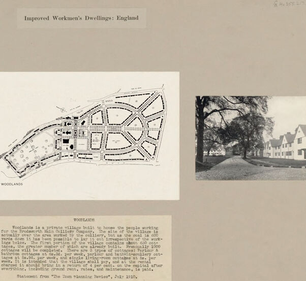
This image depicts a presentation board showcasing a plan and accompanying photographs for "Improved Workmen's Dwellings" in England.
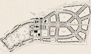
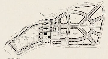
Central Image: In the middle, there is a detailed black-and-white map or layout plan labeled "WOODLANDS." It shows the organized design of houses, streets, and green spaces in a compact village layout.
Left Photograph: A black-and-white photograph displays a group of quaint, traditional-style houses amidst greenery, with large trees in the foreground.
Right Photograph: Another black-and-white photograph shows a row of similar houses lining a road, accompanied by spacious lawns and mature trees along the sides.
Text Description: Below the plan and photographs, there is a block of text explaining "Woodlands," described as a private village built to house people working for the Brodsworth Main Colliery. The text provides details on the design, purpose, infrastructure, population capacity, and commitment to community planning. It is credited as a statement published in The Town Planning Review in July 1920.
The overall presentation emphasizes the thoughtful design of housing and community spaces intended for workers, highlighting the balance between function, aesthetics, and quality of life.
Created by gpt-4o-2024-08-06 on 2025-06-10
The image is a collage layout featuring architectural planning and photographs of a housing project titled "Improved Workmen's Dwellings: England." It includes an architectural site plan centered on the page, labeled "WOODLANDS," showing a layout of houses and streets in a defined area.
On either side of the site plan, there are black and white photographs of the actual dwelling environment. The left photograph shows a row of traditional-style English houses amidst large trees, giving an impression of a serene, village-like atmosphere. The right photograph displays a similar view with rows of houses and mature trees lining a grassy area, further emphasizing the residential and peaceful setting.
Below the images and site plan is a block of text describing the "Woodlands" village. It explains that Woodlands is a private village built to house people working for Broadworth Main Colliery. The village is intended to be self-supporting, with 100 houses currently occupied, out of a planned 1000 houses. It emphasizes the provision of ample amenities, like electric lighting, indoor water closets, and educational facilities.
This composition provides both visual and textual information about an early 20th-century housing project in England designed specifically for workers, demonstrating the integration of planning and community development for improved living conditions.
Anthropic Claude
Created by anthropic.claude-3-haiku-20240307-v1:0 on 2025-06-19
The image appears to be a collection of photographs and a map related to "Improved Workmen's Dwellings: England". The left and right images show residential streets or neighborhoods, while the central image is a map or layout plan of an area called "Woodlands". The text below the central image provides some details about the Woodlands development, describing it as a "private village built to house the people working for the Improved Dwellings Company". The image does not contain any human faces, so I will not attempt to identify or name any individuals.
Created by us.anthropic.claude-3-5-sonnet-20241022-v2:0 on 2025-06-19
This image appears to be a presentation board showing "Improved Workmen's Dwellings" in England. It consists of three main elements:
- Two black and white photographs on the left and right sides showing residential streets with white houses and large trees
- A central architectural site plan or layout drawing labeled "WOODLANDS" showing a planned community layout with curved streets and building plots
- Text below the drawings that appears to describe the Woodlands development
The photographs show what appears to be a planned community with traditional English-style houses set along tree-lined streets. The houses appear to be semi-detached or row houses with white or light-colored exteriors. The mature trees give the development a established, garden-city feel.
The site plan in the center shows a thoughtfully designed layout with curved roads and what appears to be a mix of housing plots and communal spaces. This kind of planning was typical of early 20th century garden city movements in England that aimed to provide better quality housing for working people.
The overall presentation appears to be from a planning or architectural document, possibly used to showcase this development as an example of improved workers' housing in England.
Meta Llama
Created by us.meta.llama3-2-11b-instruct-v1:0 on 2025-06-10
The image presents a comprehensive overview of the Woodlands development in England, showcasing its layout and features through a combination of photographs and text.
- Title: The title "Improved Workmen's Dwellings: England" is prominently displayed at the top of the image.
- This title suggests that the image is part of a larger collection or report on improved workmen's dwellings in England.
- Map: A map of the Woodlands development is centered in the image, providing a visual representation of the layout and organization of the area.
- The map appears to be a hand-drawn or printed illustration, with various buildings and roads labeled.
- The map also includes notes and annotations, which may provide additional information about the development.
- Photographs: Three photographs are placed on either side of the map, offering a visual representation of the Woodlands development.
- The photographs depict different aspects of the development, including residential buildings, gardens, and streets.
- The photographs are likely black and white, as they appear to be from an older era.
- Text: A block of text is located below the map, providing more information about the Woodlands development.
- The text describes the development as a private village built to house the people working for the Bromsorth Main Colliery Company.
- The text also mentions that the village has been designed to provide a comfortable and healthy living environment for its residents.
- Background: The background of the image is a light brown color, which provides a neutral and clean backdrop for the other elements.
- The background also features a subtle texture, which adds depth and visual interest to the image.
In summary, the image provides a detailed and informative overview of the Woodlands development in England, showcasing its layout, features, and history through a combination of photographs and text. The image appears to be from an older era, likely from the early 20th century, and provides valuable insights into the design and construction of improved workmen's dwellings during this time period.
Created by us.meta.llama3-2-90b-instruct-v1:0 on 2025-06-10
The image presents a comprehensive visual representation of the "Improved Workmen's Dwellings: England" project, showcasing its key features and components. The title, "Improved Workmen's Dwellings: England," is prominently displayed at the top center of the page.
Central Elements:
- A map of the village, titled "WOODLANDS," occupies the central position on the page.
- Two photographs flank the map, one on each side, providing a visual representation of the village's architecture and surroundings.
- A typed description of the village is situated below the map, offering additional context and information about the project.
Visual Details:
- The map appears to be a black-and-white illustration, featuring various buildings and structures within the village.
- The photographs depict white houses with dark roofs, surrounded by trees and greenery, conveying a sense of serenity and natural beauty.
- The typed description provides a detailed account of the village's design and features, including the number of cottages, their layout, and the presence of a church.
Overall Impression:
The image effectively communicates the essence of the "Improved Workmen's Dwellings: England" project, showcasing its unique blend of architecture, natural surroundings, and community-focused design. The combination of visual elements and descriptive text provides a comprehensive understanding of the project's goals and achievements.
Amazon Nova
Created by amazon.nova-lite-v1:0 on 2025-06-07
The image is a document that contains information about the Improved Workmen's Dwellings in England. The document features three black-and-white photographs of a village with houses and trees. The first photograph is on the left side, the second is in the middle, and the third is on the right side. The middle photograph is a map of the village, showing the layout of the houses and the surrounding area. The document also includes a statement from "The Town Planning Review" from July 1910, which provides additional information about the village and its development.
Created by amazon.nova-pro-v1:0 on 2025-06-07
The image is a monochrome photograph of a paper with the title "Improved Workmen's Dwellings: England" written on it. It has a rectangular shape and is framed with a black border. The paper contains a map, two images, and a text. The map is titled "WOODLANDS" and shows a circular village with buildings and roads. The two images show the village from different angles, and the text provides information about the village and its purpose.
Google Gemini
Created by gemini-2.0-flash on 2025-05-25
Here is a description of the image:
The image is a collage of black-and-white photographs and text against a light gray background. The title at the top center reads "Improved Workmen's Dwellings: England."
There are three square photographs arranged horizontally. The one on the left shows a group of white, two-story houses with gabled roofs, partially obscured by large trees. The central image is a detailed architectural plan of "Woodlands," showing a semi-circular layout with roads and building plots. The right-hand photograph mirrors the left, showing a row of similar houses along a tree-lined street.
Below the photographs is a block of text titled "WOODLANDS," which describes the village as a private community built for the employees of the Brodsworth Main Colliery Company. It also details the types of cottages and the rental fees, stating that the village is intended to yield a 4% return on capital after expenses. The text concludes with the statement from "The Town Planning Review," dated July 1910.
Created by gemini-2.0-flash-lite on 2025-05-25
This image is an architectural presentation or historical document about housing. It appears to be a page from an architectural or urban planning publication, showing the "Improved Workmen's Dwellings" in England, specifically a village called "Woodlands."
Here's a breakdown of the components:
- Title: "Improved Workmen's Dwellings: England" sets the overall context, indicating the subject matter.
- Central Image: Plan: The primary focus is a black-and-white architectural plan or map of the Woodlands village layout. It shows streets, building blocks, and likely public spaces within the village. The plan is labeled "WOODLANDS".
- Side Images: Photos: On either side are black-and-white photographs. These photos likely show finished construction or renderings of the houses and streets to give a visual representation of how the plan was realized.
- Text: Below the central plan is descriptive text about Woodlands, explaining:
- It's a private village for workers of the Brodsworth Main Colliery Company.
- The layout of the village despite the coal below.
- The rent and return on capital.
- Where the information is sourced from.
- Overall Presentation: The layout of the page is typical of historical documentation, with the title, architectural drawings, photographs, and descriptive text together. The image is on a sepia-toned background.
Mistral Pixtral
Created by us.mistral.pixtral-large-2502-v1:0 on 2025-06-05
The image is a collage that showcases improved workmen's dwellings in England, specifically focusing on the village of Woodlands. The collage consists of three main components:
Two Photographs:
- The left photograph depicts a row of quaint houses with large trees in the foreground. The houses are situated along a curved road, and the overall setting appears to be rural and serene.
- The right photograph shows a similar scene with a row of houses, also featuring large trees and a well-maintained landscape. The houses have a uniform design, suggesting a planned community.
Central Map:
- The central part of the collage features a detailed map of Woodlands. The map illustrates the layout of the village, including the arrangement of houses, roads, and possibly other community facilities.
Descriptive Text:
- Below the central map, there is a block of text providing information about Woodlands. The text reads:
"Woodlands is a private village built to house the people working for the colliery company. It is built on the estate of Lord Hastings actually over the area worked by the colliery, but as the coal is deep (1000 feet) the ground is not affected. The first portion of the village contains about 150 houses, laid out on the garden city principle. The village will eventually contain about 1000 houses. The houses are of two types, one with bathroom and the other without. The bathroom cottages at present have a rent of 6s. 6d. per week and the others 5s. 6d. per week. It is intended that the village shall have a village hall, school, church, and shops. The roads are all well laid out and every house has its own garden. The houses are all detached or semi-detached, and each has its own garden." - The text is attributed to "The Town Planning Review," dated July 1910.
- Below the central map, there is a block of text providing information about Woodlands. The text reads:
Overall, the collage highlights the planning and design of Woodlands as a model village intended to provide improved living conditions for workers associated with the colliery. The emphasis is on the garden city principle, which promotes well-planned, self-contained communities with ample green spaces and amenities.
Qwen
Created by Qwen/Qwen2.5-VL-7B-Instruct on 2025-07-06
The image appears to be a page from a document or report detailing "Improved Workmen's Dwellings: England." It features three sections:
Left Side: A photograph of a residential area showing a row of white houses with dark roofs, surrounded by trees and open space. The houses have a classic, somewhat uniform design, and the surrounding area has a well-maintained appearance.
Center: A black-and-white map or plan labeled "WOODLANDS." The plan shows a layout of an area with evenly spaced houses, roads, and other features, likely indicating a planned community or housing development. The map includes dashed lines and symbols that could represent different types of buildings or infrastructure.
Right Side: Another photograph showing a similar residential area with white houses and trees, with a road running through the center. The architectural style and the landscaping are consistent with the left photograph.
Bottom: A text box provides additional information about the "WOODLANDS" area, mentioning that it is a private village built to house workers of the Bradford Main Oclivity Company. The text also discusses the architectural and planning aspects of the village, including the types of accommodations and financial aspects related to the maintenance and operation of the village.
The overall theme of the image is the design and layout of a planned housing development, possibly focusing on worker housing improvements in England during the early 20th century.
Created by Qwen/Qwen2.5-VL-72B-Instruct on 2025-07-06
This image appears to be a historical document showcasing the "Woodlands" housing project in England, which was designed to provide improved workmen’s dwellings. The document includes the following elements:
- Title: At the top, the text reads "Improved Workmen's Dwellings: England."
- Photographs: There are two black-and-white photographs on the left and right sides of the document. These photographs depict the actual housing units and the surrounding environment. The left photo shows a house with a tree in the foreground, while the right photo shows a street lined with houses and trees.
- Plan: In the center, there is a detailed architectural plan labeled "WOODLANDS." The plan shows the layout of the housing development, including streets, houses, and open spaces. The design appears to be well-organized with a grid-like arrangement of houses and roads.
- Text: Below the plan, there is a block of text providing additional information about the Woodlands project. It mentions that Woodlands is a private village built to house people working for the Broadmead Brick Colliery Company. The text also describes the layout, the number of houses, and the rent prices.
Overall, the document provides a comprehensive overview of the Woodlands housing project, including visual representations and detailed information about its design and purpose.
Text analysis
Amazon