Machine Generated Data
Tags
Color Analysis
Feature analysis
Amazon
Clarifai
AWS Rekognition
| Rug | 71.2% | |

Categories
Imagga
created on 2019-06-05
| paintings art | 99.3% | |
Captions
Microsoft
created by unknown on 2019-06-05
| a close up of a map | 68.4% | |
| close up of a map | 63.6% | |
| a map with text | 52.6% | |
Clarifai
No captions written
Salesforce
Created by general-english-image-caption-blip on 2025-05-17
a photograph of a map of the city of new york, showing the location of the city
Created by general-english-image-caption-blip-2 on 2025-07-07
a map of the city of new york, with the names of streets and buildings
OpenAI GPT
Created by gpt-4o-2024-11-20 on 2025-06-11
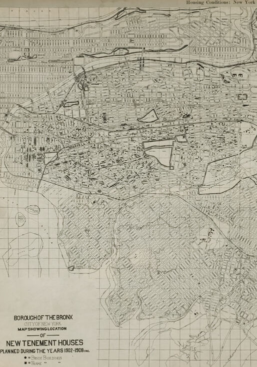
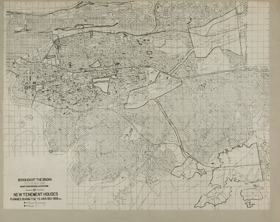
This image is a historical map titled "Borough of the Bronx – City of New York – Map Showing Location of New Tenement Houses Planned During the Years 1902–1908 inclusive." It provides an intricate layout of the Bronx borough in New York City, highlighting urban development during this specific time period.
Key features include:
- Street grid system: The map visualizes the streets and transportation infrastructure of the Bronx, reflecting urban planning of the era.
- Markings for tenement houses: Specific symbols, such as dots and small markers, indicate locations of newly planned tenement buildings from 1902 to 1908, emphasizing areas of high density and development.
- Open spaces and wooded areas: Larger sections on the southern and eastern parts display less developed areas, possibly parks, natural landscapes, or areas not yet urbanized.
- Rail lines or thoroughfares: A few linear and curved shapes likely represent train lines or major travel routes within the borough.
- Water bodies: The southeastern corner suggests proximity to waterways, likely representing the Bronx's coastal edge.
The map serves as a historical artifact showcasing early 20th-century housing trends, urban expansion, and the development of working-class housing in the Bronx during a transformative period in New York City's history.
Created by gpt-4o-2024-08-06 on 2025-06-11
The image depicts a historical map showing the Borough of the Bronx in New York City. The map is titled "Map Showing Location of New Tenement Houses Planned During the Years 1902-1908 Inc." It is part of a series titled "Housing Conditions: New York."
The map is a detailed representation of the Bronx area, with roads, streets, and various plots outlined. Specific symbols indicate the locations of the new tenement buildings planned during the stated period. The grid-like pattern suggests a systematic layout of the borough, and various landmarks or points of interest might be marked, although they are difficult to discern at this scale.
The map seems to provide an overview of urban planning and housing development in the early 20th century in one of New York City's boroughs, reflecting historical changes and urban expansion during that time.
Anthropic Claude
Created by us.anthropic.claude-3-5-sonnet-20241022-v2:0 on 2025-06-17
This is a historical map showing the Borough of The Bronx in New York City, specifically indicating the locations of "New Tenement Houses" that were planned during the years 1902-1908. The map appears to be a detailed street layout of The Bronx, with a grid pattern visible in some areas and more irregular street patterns in others. The map is drawn in black and white, with various markings likely indicating the locations of the planned tenement houses. The title appears in the bottom left corner of the map. The image quality suggests this is a vintage document, likely from the early 20th century, and it provides an interesting glimpse into urban planning and housing development in New York City during that period.
Created by anthropic.claude-3-haiku-20240307-v1:0 on 2025-06-17
The image appears to be a detailed map of the Borough of the Bronx in New York City. The map shows the layout of the area, including streets, neighborhoods, and other geographic features. It appears to be focused on the construction of new tenement houses in the area during the years 1902-1908, as indicated by the title and legend. The map provides a comprehensive view of the urban development and housing conditions in the Bronx during that time period.
Meta Llama
Created by us.meta.llama3-2-11b-instruct-v1:0 on 2025-06-10
The image presents a map of the Borough of the Bronx in New York, showcasing the location of new tenement houses planned during the years 1902-1908. The map is divided into sections by grid lines, with roads and buildings depicted in black lines. The title "Housing Conditions: New York" is displayed at the top, while the subtitle "Borough of the Bronx" is located at the bottom left. The map provides a detailed view of the area, highlighting the planned locations of new tenement houses.
- Map Title and Subtitle
- The title "Housing Conditions: New York" is displayed at the top of the map.
- The subtitle "Borough of the Bronx" is located at the bottom left of the map.
- Grid Lines and Road Network
- The map is divided into sections by grid lines, providing a clear and organized layout.
- Roads are depicted in black lines, allowing for easy navigation and identification of key routes.
- Building Locations
- Buildings are represented by black lines, indicating their presence and location within the borough.
- The map provides a comprehensive view of the building stock in the area, including both existing and planned structures.
- Planned Tenement Houses
- The map highlights the planned locations of new tenement houses, marked with small dots or symbols.
- These locations are scattered throughout the borough, indicating areas of growth and development.
- Legend and Key
- A legend or key is not explicitly provided in the image, but it is likely that the map includes a key or legend to explain the symbols and markings used.
- The legend would provide additional context and information about the map's contents and features.
In summary, the map of the Borough of the Bronx in New York provides a detailed view of the area, highlighting the planned locations of new tenement houses and the existing building stock. The map's grid lines and road network make it easy to navigate and identify key features, while the planned tenement house locations are marked with small dots or symbols. Overall, the map offers a valuable resource for understanding the housing conditions and development plans in the Borough of the Bronx during the early 20th century.
Created by us.meta.llama3-2-90b-instruct-v1:0 on 2025-06-10
The image depicts a map of the Bronx, New York, with a grid overlay and various symbols and markings. The map appears to be from the early 20th century, based on the style and content.
Key Features:
- Grid Overlay: A grid pattern is superimposed over the map, likely used for measurement or navigation purposes.
- Symbols and Markings: Various symbols and markings are scattered throughout the map, indicating different features such as buildings, roads, and landmarks.
- Title and Legend: The title "BOROUGH OF THE BRONX" is prominently displayed at the top of the map, along with a legend that explains the symbols and markings used.
- Scale and Orientation: The map includes a scale bar and compass rose, allowing users to determine distances and directions.
- Historical Significance: The map provides valuable insights into the development and growth of the Bronx during the early 20th century.
Overall Impression:
The image presents a detailed and informative map of the Bronx, showcasing its layout, infrastructure, and notable features. The use of a grid overlay and symbols adds an extra layer of complexity and functionality to the map, making it a useful tool for urban planners, historians, and researchers.
Amazon Nova
Created by amazon.nova-lite-v1:0 on 2025-06-09
The image is a map titled "Housing Conditions: New York." It depicts the borough of the Bronx in New York City, specifically focusing on the area's housing conditions during the years 1902-1906. The map is divided into a grid, with each square representing a specific location within the Bronx. The map highlights the locations of new tenement houses planned during the mentioned years, marked by different symbols such as circles, squares, and triangles. Additionally, the map includes a legend that explains the meaning of these symbols and provides information about the scale and frame of the map. The map's purpose is to provide a visual representation of the housing conditions in the Bronx during the early 20th century, allowing for analysis and understanding of the area's development and urbanization during that time period.
Created by amazon.nova-pro-v1:0 on 2025-06-09
The image shows a map of the borough of the Bronx in New York City. The map is titled "Housing Conditions: New York" and features a grid overlay. The map highlights new tenement houses planned during the years 1902-1906. The map also includes a frame and a key that explains the different symbols used on the map. The map provides a detailed view of the borough's housing conditions during the early 20th century.
Google Gemini
Created by gemini-2.0-flash on 2025-05-27
Here's a description of the image:
The image is a map of the Borough of the Bronx in New York City. It's titled "BOROUGH OF THE BRONX CITY OF NEW YORK MAP SHOWING LOCATION -OF- NEW TENEMENT HOUSES PLANNED DURING THE YEARS 1902-1908 INC." indicating it shows the locations of new tenement houses planned during that period. The map is marked with symbols indicating the type of building; brick or frame construction.
The map itself is detailed, showing streets, waterways, and the general layout of the borough. A grid overlay helps provide reference points. The top of the image is labeled "Housing Conditions: New York". The overall style is that of a historical planning or urban development map.
Created by gemini-2.0-flash-lite on 2025-05-27
The image is a map of the Bronx in New York City, showing the locations of new tenement houses planned between 1902 and 1908. The map is in black and white and appears to be from the early 20th century, given its style and the time period referenced. The map includes the title "Housing Conditions: New York" and details on what the map is showing. The map is laid out on a grid, likely for reference, and symbols are used to denote the type of buildings, whether brick or frame.
Mistral Pixtral
Created by us.mistral.pixtral-large-2502-v1:0 on 2025-06-06
The image is a historical map of the Bronx, a borough of New York City, showing the locations of new tenement houses planned during the years 1932 to 1939. The map is detailed and includes a grid overlay for precise location identification.
Key features of the map include:
Title and Description:
- The title at the bottom left reads: "Borough of the Bronx, City of New York, Map Showing Location of New Tenement Houses Planned During the Years 1932-1939 Inc."
- The map is part of a series related to housing conditions in New York.
Geographical Coverage:
- The map covers the entire Bronx borough, showing its boundaries and neighboring areas.
- Major geographical features and landmarks are outlined, including rivers, parks, and major roads.
Tenement Houses:
- The locations of the new tenement houses are marked with dots. These dots are concentrated in certain areas, indicating where the new housing developments were planned.
- The map uses different symbols or shading to represent tenement houses and possibly other types of housing or land use.
Grid System:
- A grid overlay is present, likely to help in accurately pinpointing the locations of the tenement houses and other features.
Additional Information:
- The map includes a legend or key, although the specific details are not visible in this image.
- The map appears to be part of a larger series or report on housing conditions in New York City, as indicated by the title at the top: "Housing Conditions: New York."
Overall, the map provides a detailed visual representation of urban planning efforts in the Bronx during the 1930s, focusing on the development of new tenement housing.
Qwen
Created by Qwen/Qwen2.5-VL-7B-Instruct on 2025-07-16
This image is a historical map of the Bronx, New York, titled "Housing Conditions: New York" and specifically labeled as "Borough of the Bronx, New York." The map is annotated with various symbols indicating the locations of new tenement houses planned during the years 1902 to 1908.
The map features a detailed layout of the Bronx, with a grid overlay that helps in the precise mapping of the area. Various symbols are used to denote different types of buildings and planned developments. The map is likely a planning document or a survey used to visualize the proposed layout of new housing as part of urban development efforts in the early 20th century. The text at the bottom of the map provides a legend for interpreting the symbols used for the buildings and other geographical features.
Created by Qwen/Qwen2.5-VL-72B-Instruct on 2025-07-16
This image is a black-and-white map of the Bronx, a borough of New York City. The title at the bottom left corner reads "BOROUGH OF THE BRONX CITY OF NEW YORK, MAP SHOWING LOCATION OF NEW TENEMENT HOUSES PLANNED DURING THE YEARS 1902-1908 INC." The map is detailed, showing a grid overlay and various symbols and lines representing streets, buildings, and other features. The text "Housing Conditions: New York" is visible at the top right corner. The map appears to be an old document, possibly from the early 20th century, given the years mentioned and the style of the map.
Text analysis
Amazon