Machine Generated Data
Tags
Color Analysis
Feature analysis
Amazon
Clarifai

AWS Rekognition
| Poster | 99.4% | |


Categories
Imagga
created on 2019-06-05
| paintings art | 55.9% | |
| text visuals | 42.3% | |
| interior objects | 1.2% | |
Captions
Microsoft
created by unknown on 2019-06-05
| a close up of a monitor | 37.9% | |
Clarifai
No captions written
Salesforce
Created by general-english-image-caption-blip on 2025-05-15
a photograph of a map of the united states of america with a map of the united states
Created by general-english-image-caption-blip-2 on 2025-07-04
a map of the united states showing the states that were affected by the great depression
OpenAI GPT
Created by gpt-4o-2024-11-20 on 2025-06-12
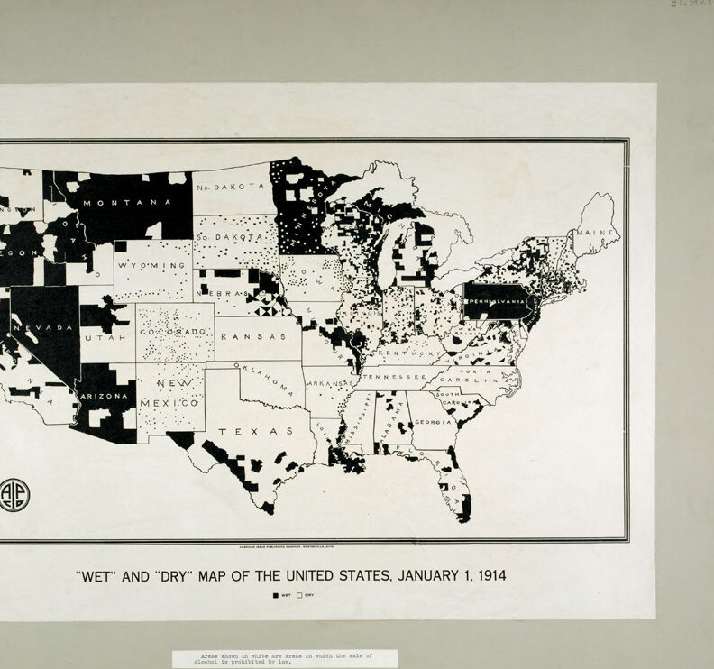
This is a historical map of the United States titled “Wet and Dry Map of the United States, January 1, 1914.” It visually represents the state of prohibition laws in the country at that time regarding the sale of alcohol.
On the map:
- Black areas denote regions where alcohol sales ("wet" areas) were legal.
- White areas represent regions where the sale of alcohol ("dry" areas) was prohibited by local laws.
The map is divided state by state, with further subdivisions showing county or regional differences in alcohol regulation. Dark black regions are mostly concentrated in the western states and parts of the Midwest, while the eastern states and some southern areas show mixed patterns of wet and dry zones. There is a clear indication of the gradual spread of prohibition laws during the early 20th century, before nationwide prohibition under the 18th Amendment was implemented in 1920.
Created by gpt-4o-2024-08-06 on 2025-06-12
The image depicts a "Wet" and "Dry" map of the United States as of January 1, 1914. It illustrates areas where the sale of alcohol was legally permitted ("wet" areas, shaded in white) and where it was prohibited ("dry" areas, shaded in black). The map uses a simple black-and-white color scheme to differentiate these areas across the country. From the map, it is clear that the western part of the United States has a significant number of dry areas, with several entire states being dry. The map also shows a mix of wet and dry areas in the midwestern and eastern United States, with more wet areas along the East Coast. The map provides historical insight into the spread of temperance and prohibition movements in the United States prior to the nationwide prohibition that would begin in 1920.
Anthropic Claude
Created by anthropic.claude-3-haiku-20240307-v1:0 on 2025-06-15
The image is a "wet" and "dry" map of the United States from January 1, 1914. It shows the different regions of the country based on their alcohol prohibition status at the time, with black areas indicating "dry" or prohibition regions and white areas indicating "wet" or non-prohibition regions. The map covers the entire continental United States, with state boundaries clearly delineated. It provides a visual representation of the alcohol laws and policies across the country during that historical period.
Created by us.anthropic.claude-3-5-sonnet-20241022-v2:0 on 2025-06-15
This is a historical map titled "WET" AND "DRY" MAP OF THE UNITED STATES, JANUARY 1, 1914. The map shows the United States with different regions marked in either black (presumably "wet" areas where alcohol was legal) or white (presumably "dry" areas where alcohol was prohibited). The map was created during the period leading up to national Prohibition in the United States.
The western states like Montana and Nevada appear to have large "wet" areas marked in black, while many central and southern states show more "dry" areas in white. The map provides an interesting visualization of how alcohol prohibition varied across different regions of the country before the nationwide prohibition was enacted in 1920 with the 18th Amendment.
There appears to be a logo or emblem in the bottom left corner of the map. The overall presentation is in a simple black and white style typical of maps from that era.
Meta Llama
Created by us.meta.llama3-2-11b-instruct-v1:0 on 2025-06-11
The image presents a map of the United States, dated January 1, 1914, with the title "WET" AND "DRY" MAP OF THE UNITED STATES, JANUARY 1, 1914. The map is divided into states, each marked with either a black or white square. Black squares indicate areas where the sale of alcohol was prohibited by law, while white squares represent areas where alcohol was legal.
- Map Title and Date
- The map is titled "WET" AND "DRY" MAP OF THE UNITED STATES, JANUARY 1, 1914.
- The date on the map is January 1, 1914.
- Map Legend
- The legend explains that black squares represent areas where the sale of alcohol was prohibited by law.
- White squares represent areas where alcohol was legal.
- Map Content
- The map shows the United States divided into states.
- Each state is marked with either a black or white square, indicating whether alcohol was legal or prohibited.
- The map provides a visual representation of the legal status of alcohol in each state on January 1, 1914.
- Background
- The background of the image is a light green color.
- The map is centered in the image, with a thin black border around it.
- Overall
- The image provides a historical snapshot of the legal status of alcohol in the United States on January 1, 1914.
- The map is a useful tool for understanding the evolution of alcohol laws in the country over time.
Created by us.meta.llama3-2-90b-instruct-v1:0 on 2025-06-11
The image depicts a map of the United States, titled "WET" AND "DRY" MAP OF THE UNITED STATES, JANUARY 1, 1914. The map is divided into two categories: "wet" and "dry," with the former indicating areas where alcohol is permitted by law and the latter indicating areas where it is prohibited.
Key Features:
- Map Title: "WET" AND "DRY" MAP OF THE UNITED STATES, JANUARY 1, 1914
- Color Scheme: Black and white
- Categories: "Wet" (alcohol permitted) and "dry" (alcohol prohibited)
- Date: January 1, 1914
Conclusion:
The image provides a visual representation of the legal status of alcohol in the United States as of January 1, 1914. It highlights the geographical distribution of "wet" and "dry" areas, offering valuable insights into the historical context of alcohol regulation in the country.
Amazon Nova
Created by amazon.nova-lite-v1:0 on 2025-06-05
This is a black-and-white map of the United States from 1914. The map is titled "Wet" and "Dry" Map of the United States, January 1, 1914. The map shows the states in black and white, with some areas shaded in different colors. The map also includes a small logo in the bottom left corner. The map is framed in a white border with a black outline. The map shows the United States with different regions marked as "wet" or "dry." The map is dated January 1, 1914.
Created by amazon.nova-pro-v1:0 on 2025-06-05
The image shows a map of the United States of America. The map is printed in black and white. The map is titled "Wet" and "Dry" Map of the United States, January 1, 1914. The map is divided into different sections, each representing a state. The states are labeled with their names. The map also includes a legend that explains the different colors used to represent the "wet" and "dry" areas. The "wet" areas are represented by a darker shade of black, while the "dry" areas are represented by a lighter shade of black. The map also includes a note that explains that areas in white are areas in which the sale of alcohol is prohibited by law.
Google Gemini
Created by gemini-2.0-flash on 2025-05-08
Here's a description of the image:
The image displays a black and white map of the United States, titled "WET" and "DRY" MAP OF THE UNITED STATES, JANUARY 1, 1914." The map is framed by a double-lined rectangle. Each state's name is printed in capital letters within its borders.
The map is divided into counties, which are colored either black or white. A small legend distinguishes between "wet" and "dry" areas; black represents "wet" and white represents "dry." This likely refers to areas where the sale of alcohol was permitted ("wet") and prohibited ("dry").
At the bottom of the image, a brief caption clarifies that "Areas shown in white are areas in which the sale of alcohol is prohibited by law." In the lower-left corner of the map is a circular logo containing the letters "AP." The overall aesthetic of the map is vintage, reflective of early 20th-century cartography.
Created by gemini-2.0-flash-lite on 2025-05-08
Here's a description of the image:
Overview:
The image is a historical map of the United States, dated January 1, 1914. The map is labeled "Wet and Dry Map" and is meant to visually represent the status of alcohol prohibition across the country.
Visual Elements:
- Map of the United States: The central focus is a detailed outline of the United States, including state borders. The states are named.
- Color Coding: The map uses a color-coding system, likely to indicate areas that are "wet" (where the sale of alcohol is permitted) and "dry" (where the sale of alcohol is prohibited). The legend at the bottom of the map indicates what color (or lack thereof) represents what.
- Black and White: The image is in black and white.
- Text: The image includes titles and labels, such as the map title ("Wet and Dry Map of the United States, January 1, 1914") and state names.
Interpretation:
The map depicts the state of alcohol prohibition at the time. The "wet" and "dry" designations reveal the varying local and state laws regarding alcohol sales, a critical context for understanding the social and political debates leading up to the national Prohibition movement.
Mistral Pixtral
Created by us.mistral.pixtral-large-2502-v1:0 on 2025-06-05
The image is a black-and-white map of the United States titled "Wet and Dry Map of the United States, January 1, 1914." It depicts areas designated as "wet" and "dry" in relation to alcohol prohibition laws.
- Black Areas: These represent "dry" regions where the sale of alcohol was prohibited.
- White Areas: These represent "wet" regions where the sale of alcohol was allowed.
The map shows a significant portion of the country, especially in the southern and western states, as dry. States like Montana, Nevada, Arizona, and parts of Texas, Oklahoma, and Arkansas are predominantly black, indicating they were dry. In contrast, many eastern and midwestern states have larger white areas, indicating they were wet.
The map was created by the American Issue Publishing Company, as indicated by the logo in the bottom left corner. There is also a note at the bottom of the map stating, "Areas shown in white city areas in which the sale of alcoholic beverages was allowed."
This map provides a historical snapshot of the geographic distribution of alcohol prohibition laws across the United States at the beginning of 1914.
Qwen
Created by Qwen/Qwen2.5-VL-7B-Instruct on 2025-07-28
The image is a historical map titled "Wet and Dry Map of the United States, January 1, 1914." It illustrates the distribution of wet areas (where the sale of alcohol was allowed) and dry areas (where the sale of alcohol was prohibited by law) in the United States as of January 1, 1914. The map uses shading and dotted patterns to differentiate between the two categories. States are labeled, and the map includes a legend in the bottom left corner explaining the symbols used for wet and dry areas. The bottom of the image includes a note explaining that the areas shown in white are those where the sale of alcohol is prohibited by law.
Created by Qwen/Qwen2.5-VL-72B-Instruct on 2025-07-28
This image is a black-and-white map of the United States titled "Wet" and "Dry" Map of the United States, January 1, 1914. The map uses a pattern of dots to indicate areas where the sale of alcohol was prohibited by law (dry areas) and areas where it was not (wet areas).
- Dry areas are marked with a dense pattern of black dots, indicating regions where the sale of alcohol was prohibited.
- Wet areas are left blank, indicating regions where the sale of alcohol was not prohibited.
The map includes all 48 contiguous states of the U.S. at that time, with state boundaries clearly marked. Some states are entirely dry, some are entirely wet, and others have a mix of dry and wet regions.
There is a legend at the bottom of the map that explains the symbols used:
- A solid black square represents a "Wet" area.
- An outlined square represents a "Dry" area.
The map also includes a note: "Areas shown in white are areas in which the sale of alcohol is prohibited by law," which clarifies that the white areas are actually dry areas, and the black areas are wet areas.
The map is labeled with the date January 1, 1914, indicating the time period it represents. There is also a logo in the bottom left corner, which appears to be related to the organization that created or published the map.
Text analysis
Amazon