Machine Generated Data
Tags
Color Analysis
Feature analysis
Amazon
Clarifai
AWS Rekognition
| Poster | 100% | |


Categories
Imagga
created on 2019-06-05
| paintings art | 95.8% | |
| text visuals | 4% | |
Captions
Microsoft
created by unknown on 2019-06-05
| a close up of text on a white surface | 54.9% | |
| a close up of text on a white background | 54.8% | |
| a close up of text on a black background | 53.8% | |
Clarifai
No captions written
Salesforce
Created by general-english-image-caption-blip-2 on 2025-07-08
a map of the united states showing the number of black people in each state
Created by general-english-image-caption-blip on 2025-05-03
a photograph of a map of the united states with a map of the united states
OpenAI GPT
Created by gpt-4o-2024-11-20 on 2025-06-07
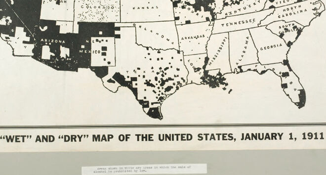
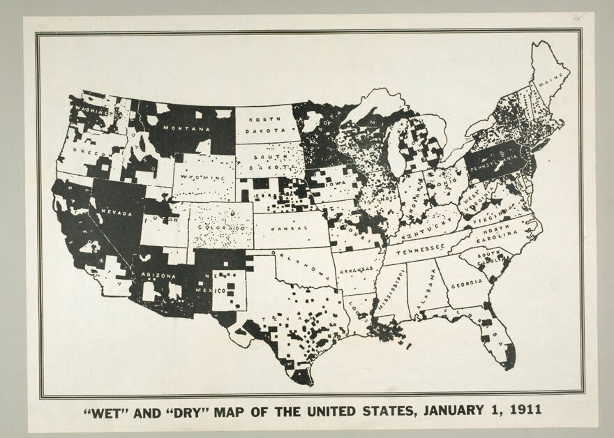
This is a historical map titled “Wet” and “Dry” Map of the United States, January 1, 1911. It visually depicts areas in the U.S. where alcohol sales and consumption were either allowed ("wet") or prohibited ("dry") by law during the early 20th century, prior to the nationwide Prohibition era.
The states and regions are colored to indicate the legislative stance on alcohol. Solid black areas represent “dry” regions where alcohol was banned, while lighter regions indicate “wet” zones where alcohol sales were permitted. This map highlights the growing influence of the temperance movement, which gained momentum in the years leading up to Prohibition. The map provides a symbolic snapshot of the social and political divisions around alcohol regulation in the U.S. during that time.
Created by gpt-4o-2024-08-06 on 2025-06-07
The image is a historical map titled "WET AND DRY MAP OF THE UNITED STATES, JANUARY 1, 1911." It depicts the status of prohibition in various parts of the United States at that time. The map uses shading to differentiate between "wet" and "dry" areas. "Wet" areas, where the sale of alcohol was permitted, are represented in dark shading or solid colors, while "dry" areas, where alcohol sales were restricted or prohibited, are shown in lighter shading or white. The map presents the contiguous United States, with state borders clearly outlined, and within each state, there are smaller patches indicating counties or regions that were either wet or dry. The map reflects the patchwork of local laws regarding alcohol sales prior to the nationwide prohibition that began in 1920.
Anthropic Claude
Created by anthropic.claude-3-haiku-20240307-v1:0 on 2025-06-12
The image is a black and white map of the United States, dated January 1, 1911. It is labeled as a "Wet" and "Dry" map, indicating which states allowed or prohibited the sale of alcohol at that time. The map shows the different states shaded in various patterns to represent their "wet" or "dry" status. The map provides a historical perspective on the temperance movement and the regulation of alcohol in the early 20th century United States.
Created by us.anthropic.claude-3-opus-20240229-v1:0 on 2025-06-12
The image shows a black and white map of the United States from January 1, 1911. The map is titled "'Wet' and 'Dry' Map of the United States, January 1, 1911".
The map divides the country into various regions, with each state labeled. Some states and regions are shaded in black, while others are left white. Based on the title, this shading likely indicates whether each state was "wet" (allowing alcohol sales) or "dry" (prohibiting alcohol sales) at the start of 1911, several years before nationwide Prohibition began.
The detailed shading pattern reveals the patchwork of alcohol laws across the country at that time, with many states, especially in the South, already having "dry" laws, while states in the Northeast, Midwest and West were still "wet". It provides an interesting historical snapshot of the state-by-state progress of the temperance movement in the early 20th century leading up to Prohibition.
Created by us.anthropic.claude-3-5-sonnet-20241022-v2:0 on 2025-06-12
This is a historical map of the United States from January 1, 1911, showing "wet" and "dry" areas during the period leading up to Prohibition. The dark areas represent "wet" regions where alcohol was legal, while the white or light areas represent "dry" regions where alcohol was prohibited. The map shows significant variation across the country, with large portions of the western states like Montana and Arizona appearing "wet," while many southern and northeastern states have substantial "dry" areas. The map provides an interesting snapshot of alcohol regulation in America nearly a decade before national Prohibition went into effect. It illustrates how alcohol prohibition was already in place in various regions before the 18th Amendment was ratified in 1919.
Meta Llama
Created by us.meta.llama3-2-90b-instruct-v1:0 on 2025-05-25
The image presents a map of the United States, titled "WET" AND "DRY" MAP OF THE UNITED STATES, JANUARY 1, 1911. The map is divided into two categories: "wet" and "dry," with each state or territory marked accordingly.
Key Features:
- Title: The title is prominently displayed at the bottom of the map, providing context for the information presented.
- Map Legend: A small legend is located below the title, although it is too small to read clearly. It likely explains the color-coding system used to distinguish between "wet" and "dry" areas.
- Color-Coding: The map employs a simple color scheme, with black representing "dry" areas and white indicating "wet" areas. This visual distinction allows for easy identification of the different regions.
- State and Territory Boundaries: The map clearly outlines the borders of each state and territory, making it easy to distinguish between them.
- Geographical Features: While the map does not provide detailed geographical information, it does show the general shape and layout of the country.
Conclusion:
In summary, the image is a historical map of the United States, dated January 1, 1911, which categorizes states and territories as either "wet" or "dry." The map uses a simple color-coding system to distinguish between these categories, making it easy to understand at a glance.
Created by us.meta.llama3-2-11b-instruct-v1:0 on 2025-05-25
The image is a map of the United States, titled "WET" AND "DRY" MAP OF THE UNITED STATES, JANUARY 1, 1911. The map is divided into states, with some states shaded in black and others left white. The shaded states are labeled as "DRY", while the unshaded states are labeled as "WET". The map appears to be a historical document, likely created to illustrate the legal status of alcohol prohibition in each state at the time.
The map shows that the majority of states were "WET" (unshaded), indicating that they allowed the sale and consumption of alcohol. In contrast, the "DRY" states (shaded) had laws prohibiting the sale and consumption of alcohol. The map also highlights the regional variations in alcohol laws, with the Northeast and Midwest having more "DRY" states than the South and West.
Overall, the map provides a visual representation of the complex and varied landscape of alcohol laws in the United States during the early 20th century. It suggests that while some states had strict laws prohibiting alcohol, others had more lenient laws allowing its sale and consumption.
Amazon Nova
Created by amazon.nova-pro-v1:0 on 2025-05-24
The image is a black-and-white map of the United States, titled "Wet" and "Dry" Map of the United States, January 1, 1911. The map is divided into sections representing different states and territories, with some areas shaded in black to indicate "wet" regions and others left blank to indicate "dry" regions. The map also includes a legend explaining the shading and a note about the prohibition of alcohol in certain areas.
Created by amazon.nova-lite-v1:0 on 2025-05-24
The image is a map of the United States, dated January 1, 1911. The map is in black and white, with different shades of gray used to indicate areas where alcohol sales were prohibited by law. The map is titled "Wet" and "Dry" Map of the United States, January 1, 1911. The map shows the entire United States, with each state outlined in black. The states are divided into smaller regions, and some of these regions are shaded in different shades of gray to indicate areas where alcohol sales were prohibited. The map also includes a key that explains the different shades of gray used to indicate the different types of alcohol restrictions. The map is displayed on a white background, and there is a small label at the bottom of the image that reads "Areas shown in white are areas in which the sale of alcohol is prohibited by law."
Google Gemini
Created by gemini-2.0-flash-lite on 2025-04-29
Here's a description of the image:
The image is a black and white map of the United States, labeled "Wet" and "Dry" Map of the United States, January 1, 1911." The map is a representation of the legal status of alcohol sales in the country at that time.
Color Coding: The map uses a visual coding system to differentiate between "wet" and "dry" areas:
- States or areas in black show "dry" territories, meaning the sale of alcohol was prohibited.
- States or areas in white show "wet" territories, meaning the sale of alcohol was allowed.
Details: The map is very detailed. The states are labeled with their names, and there is an indication of which areas within the states are "wet" or "dry" and the area that the sale of alcohol is prohibited by law. The pattern may suggest how Prohibition progressed.
Historical Context: This map likely represents the situation before or during the early stages of the Temperance movement and the eventual national Prohibition in the United States, which began in 1920. The "dry" areas suggest the geographical spread of anti-alcohol sentiments and the legal restrictions that were starting to be implemented.
Created by gemini-2.0-flash on 2025-04-29
Here's a description of the image:
The image is a black and white map of the United States, dated January 1, 1911. It is titled "WET" AND "DRY" MAP OF THE UNITED STATES, JANUARY 1, 1911.
The map indicates areas where the sale of alcohol is either permitted ("wet") or prohibited ("dry"). "Wet" areas are shown in black, while "dry" areas are shown in white.
The map is surrounded by a thin black border. The map shows the outline of the continental United States, including state boundaries. The states are labeled. The map gives a visual representation of the patchwork of alcohol regulations across the country at the time.
Mistral Pixtral
Created by us.mistral.pixtral-large-2502-v1:0 on 2025-05-26
This image is a historical map titled "Wet and Dry Map of the United States, January 1, 1911." It depicts the status of alcohol prohibition laws across the United States at the beginning of 1911. The map uses black and white color coding to indicate areas where alcohol was prohibited ("dry") and areas where it was allowed ("wet").
Key observations from the map:
Dry Areas (Black):
- Many counties and regions in the southern states, including Texas, Oklahoma, Arkansas, Louisiana, Mississippi, Alabama, Georgia, and Florida, are marked as dry.
- Significant portions of the western states, such as Montana, Nevada, Arizona, and parts of California, are also dry.
- Several counties in the Midwest, including parts of Minnesota, Iowa, Illinois, and Michigan, are marked as dry.
Wet Areas (White):
- Most of the northeastern states, including New York, Pennsylvania, and New England, are predominantly wet.
- The central and eastern parts of the Midwest, including Ohio, Indiana, and Kentucky, are largely wet.
- Some western states like Wyoming, Colorado, and parts of Utah and New Mexico are also wet.
Mixed Areas:
- Some states show a mix of wet and dry counties, indicating varying local laws within the state. For example, Kansas and Missouri have both wet and dry regions.
Notable Exceptions:
- North and South Dakota appear to be entirely dry.
- Large portions of the Pacific Northwest, including Washington and Oregon, are wet.
The map provides a visual representation of the patchwork of alcohol prohibition laws across the United States at the start of 1911, reflecting the varying attitudes and legislative actions towards alcohol consumption in different regions of the country.
Qwen
No captions written
Text analysis
Amazon