Machine Generated Data
Tags
Color Analysis
Feature analysis
Amazon
Clarifai
AWS Rekognition
| Poster | 99.9% | |


Categories
Imagga
created on 2019-06-05
| text visuals | 61.7% | |
| paintings art | 38% | |
Captions
Microsoft
created by unknown on 2019-06-05
| a close up of text on a white surface | 57.8% | |
| a close up of text on a white background | 57.7% | |
| a close up of text on a black background | 57.6% | |
Clarifai
No captions written
Salesforce
Created by general-english-image-caption-blip on 2025-05-17
a photograph of a map of the united states showing the extent of the united states
Created by general-english-image-caption-blip-2 on 2025-07-06
a map of the united states showing the number of people in each state
OpenAI GPT
Created by gpt-4o-2024-11-20 on 2025-06-11
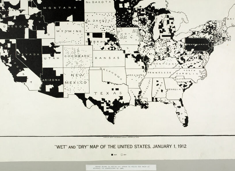
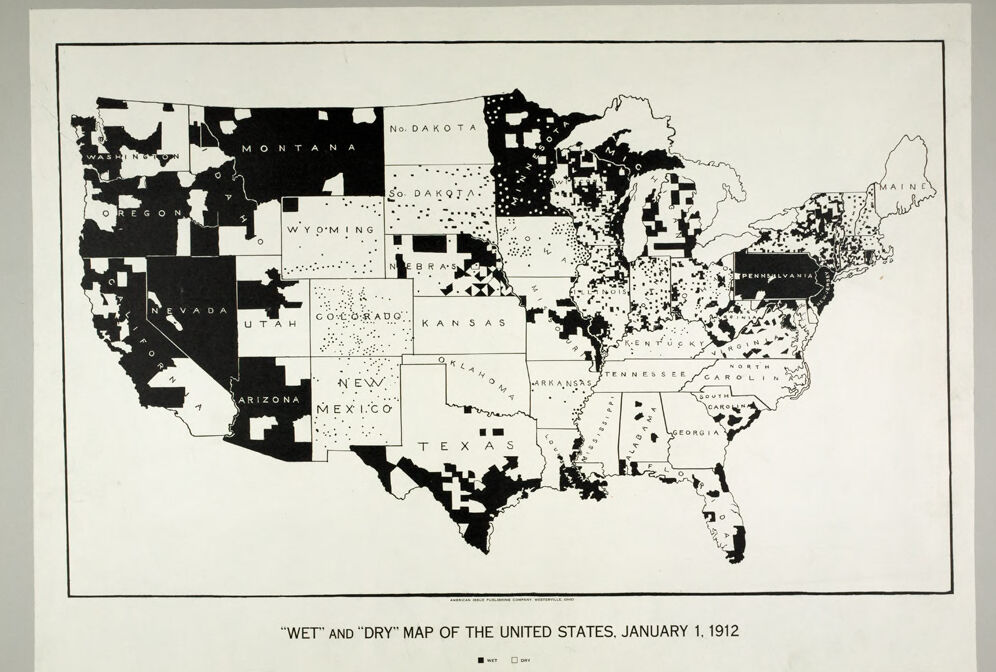
This image is a historical map of the United States from January 1, 1912, titled the "Wet and Dry" map. It categorizes counties in the U.S. based on alcohol prohibition laws at the time.
- Black areas represent "dry" regions where alcohol was prohibited by law.
- White areas represent "wet" regions where alcohol sales and consumption were allowed.
The map shows significant portions of the country, particularly in the South and Midwest, as "dry," while many areas in the western states and parts of the Northeast remain "wet." It reflects the rising influence of the temperance movement and the push toward nationwide alcohol prohibition, which culminated in the 18th Amendment in 1920.
Created by gpt-4o-2024-08-06 on 2025-06-11
This image is a historical map titled "Wet and Dry Map of the United States, January 1, 1912." It depicts the status of prohibition laws across different regions of the United States as of that date.
The map uses two colors to indicate areas where the sale of alcohol was permitted ("wet") and areas where it was prohibited or restricted ("dry"). Black areas represent "dry" regions where alcohol sales were likely restricted, while white areas represent "wet" regions where alcohol sales were allowed. There are clear variations across states, with some states being entirely dry, some entirely wet, and others a mix of both in different regions or counties.
The western half of the country has more large black areas indicating dry regions, whereas the eastern part has a more intricate mix of wet and dry areas. This map illustrates the spread of the temperance movement in the early 20th century America, prior to the nationwide Prohibition era which began in 1920.
Anthropic Claude
Created by anthropic.claude-3-haiku-20240307-v1:0 on 2025-06-17
The image is a "wet" and "dry" map of the United States, dated January 1, 1912. It shows the various states and regions of the country, with black areas representing "wet" regions where alcohol was legal, and white areas representing "dry" regions where alcohol was prohibited. The map provides a detailed view of the alcohol laws and regulations across the United States at that time.
Created by us.anthropic.claude-3-5-sonnet-20241022-v2:0 on 2025-06-17
This is a historical map titled "Wet and Dry Map of the United States, January 1, 1912" which appears to show the status of prohibition across the United States. The black or shaded areas likely represent "dry" territories where alcohol was prohibited, while the white or unshaded areas represent "wet" territories where alcohol was legal. The map shows state boundaries and names, with particularly heavy concentrations of dry areas in states like Montana, Washington, and Nevada in the West, as well as scattered areas throughout other parts of the country. The map provides an interesting visualization of how prohibition laws varied across different regions of the United States during the early 20th century, before national prohibition was enacted in 1920.
Meta Llama
Created by us.meta.llama3-2-90b-instruct-v1:0 on 2025-06-01
The image depicts a map of the United States, dated January 1, 1912, with a title that reads "WET" AND "DRY" MAP OF THE UNITED STATES. The map is divided into states, each represented by a unique color scheme. Some states are entirely black, while others are white or feature a combination of both colors.
Upon closer inspection, it becomes apparent that the black areas on the map correspond to regions where alcohol was prohibited by law at the time. This information is supported by a small text box at the bottom of the image, which states, "Areas shown in white or gray in which the sale of alcohol is prohibited by law."
Overall, the map provides a visual representation of the legal status of alcohol in different parts of the United States during the early 20th century.
Created by us.meta.llama3-2-11b-instruct-v1:0 on 2025-06-01
The image presents a map of the United States, titled "WET" AND "DRY" MAP OF THE UNITED STATES, JANUARY 1, 1912. The map is divided into states, each marked with either a black or white square to indicate whether it was wet or dry on January 1, 1912.
- The map is dated January 1, 1912.
- The map is divided into states, each marked with either a black or white square to indicate whether it was wet or dry on January 1, 1912.
- The map shows that most of the western states were wet, while the eastern states were dry.
- The map also shows that some states had a mix of wet and dry areas.
- The map provides a visual representation of the distribution of wet and dry areas in the United States on January 1, 1912.
The map provides a snapshot of the distribution of wet and dry areas in the United States on January 1, 1912. It shows that most of the western states were wet, while the eastern states were dry. The map also highlights the diversity of wet and dry areas within individual states. Overall, the map provides a useful tool for understanding the geography of wet and dry areas in the United States during this time period.
Amazon Nova
Created by amazon.nova-pro-v1:0 on 2025-05-31
The image is a black-and-white map of the United States titled "WET" and "DRY" MAP OF THE UNITED STATES. JANUARY 1. 1912." It shows the states with different shadings to indicate their status regarding alcohol prohibition. The map is divided into two categories: "WET" and "DRY."
"WET" states are those where the sale of alcohol is permitted, and they are depicted in a lighter shade. These states include New York, Pennsylvania, Maryland, and others.
"DRY" states are those where the sale of alcohol is prohibited, and they are shown in a darker shade. These states include Kansas, North Dakota, and others.
The map also highlights areas within states where alcohol sales are prohibited by law, indicated by a specific pattern or shading. This distinction is crucial for understanding the geographical distribution of alcohol prohibition laws across the United States during that period.
The map is a historical document that provides insight into the social and legal landscape of the United States in the early 20th century, particularly in the context of the temperance movement and the eventual adoption of nationwide prohibition with the 18th Amendment in 1919.
Created by amazon.nova-lite-v1:0 on 2025-05-31
The image is a black-and-white map of the United States, dated January 1, 1912. The map is titled "Wet" and "Dry" Map of the United States, indicating that it highlights areas where the sale of alcohol is permitted ("wet") and where it is prohibited ("dry"). The map is divided into sections representing each state, with the states labeled in white text on a black background. The map also includes a small note at the bottom, stating that the sale of alcohol is prohibited by law in certain areas.
Google Gemini
Created by gemini-2.0-flash on 2025-06-05
The image is a "Wet" and "Dry" map of the United States, dated January 1, 1912. The map uses black and white coloring to indicate areas where the sale of alcohol was either permitted ("wet") or prohibited ("dry"). The western states like Nevada, Oregon, and Washington show significant portions designated as "dry," while the eastern and midwestern states exhibit a mix of "wet" and "dry" areas. The overall pattern suggests a complex and varied landscape of alcohol regulation across the country at that time.
Created by gemini-2.0-flash-lite on 2025-06-05
Here's a description of the image:
The image is a "Wet" and "Dry" map of the United States from January 1, 1912. It's a simple, black-and-white map, likely created to illustrate the status of prohibition at the time.
Key Features:
- Political Map: The map outlines the boundaries of the United States, with the states clearly labeled.
- "Wet" and "Dry" Designations: The map uses a black and white key to distinguish between "wet" areas (where alcohol sales were legal) and "dry" areas (where alcohol sales were prohibited). It seems black represents "wet" and white is "dry."
- Distribution Patterns: The black and white areas are unevenly distributed across the country, highlighting the different states' approaches to alcohol sales. Some states appear to be mostly "wet," while others are largely "dry," and some have a mix of both.
- Historical Context: The map's date (January 1, 1912) places it during the Progressive Era and the rise of the temperance movement in the United States, which was aiming to ban the sale of alcohol.
In essence, this map offers a snapshot of the complex landscape of prohibition sentiment and laws in the US at a crucial point in history.
Mistral Pixtral
Created by us.mistral.pixtral-large-2502-v1:0 on 2025-06-06
The image is a historical map of the United States titled "Wet and Dry Map of the United States, January 1, 1912." The map visually represents the legal status of alcohol sales across the country at that time.
- Black Areas (Dry): These regions are marked in black and indicate areas where the sale of alcohol was prohibited by law.
- White Areas (Wet): These regions are marked in white and indicate areas where the sale of alcohol was allowed.
Key observations from the map:
- Many states in the western part of the United States, such as Montana, Nevada, Utah, and Arizona, are predominantly black, indicating they were dry.
- States like Texas, Kansas, and parts of the Midwest also show significant dry areas.
- The eastern part of the United States, particularly the Northeast and parts of the Southeast, have more white areas, indicating they were wet.
- The map shows a mix of wet and dry areas within many states, reflecting varying local laws and regulations regarding alcohol sales.
The map provides a snapshot of the patchwork of alcohol prohibition laws across the United States at the beginning of 1912, before national prohibition was enacted in 1920.
Qwen
Created by Qwen/Qwen2.5-VL-7B-Instruct on 2025-07-28
This image is a map of the United States titled "Wet" and "Dry" Map of the United States, January 1, 1912. The map uses two different shades to indicate the legal status of alcohol in each state on that date:
- Black represents "Wet" states, where the sale of alcohol is legal.
- White represents "Dry" states, where the sale of alcohol is prohibited by law.
The map shows a clear regional difference in the legal status of alcohol, with the majority of the country appearing white (dry) compared to the few black areas (wet). Some states are partially shaded, indicating a mix of wet and dry regions within them. The map is a historical representation of the state-by-state intoxicating beverage laws in the U.S. during the early 20th century, a period marked by the enforcement of Prohibition.
Created by Qwen/Qwen2.5-VL-72B-Instruct on 2025-07-28
This image is a historical map of the United States, titled "Wet and Dry Map of the United States, January 1, 1912." The map uses a black and white color scheme to differentiate between wet and dry areas.
- Wet areas are shown in black, indicating regions where the sale of alcohol was not prohibited by law.
- Dry areas are shown in white, indicating regions where the sale of alcohol was prohibited by law.
The map includes all the states of the United States at that time, with state boundaries clearly marked. The states are labeled with their names, and the distribution of wet and dry areas varies across the country. Some states are entirely wet or dry, while others have a mix of both.
The map provides a visual representation of the early stages of the temperance movement in the United States, showing how different regions had varying laws regarding the sale of alcohol. It is a snapshot of the legal and social landscape regarding alcohol in the U.S. in the early 20th century.
Text analysis
Amazon