Machine Generated Data
Tags
Color Analysis
Feature analysis
Amazon
Clarifai

Clarifai
| Poster | 58.8% | |

Categories
Imagga
created on 2019-06-05
| paintings art | 48.6% | |
| text visuals | 44.8% | |
| interior objects | 4.2% | |
| beaches seaside | 1.4% | |
Captions
Microsoft
created by unknown on 2019-06-05
| a close up of a sign | 70.6% | |
| a blue and white sign | 50.6% | |
| a sign on a wall | 50.5% | |
Clarifai
No captions written
Salesforce
Created by general-english-image-caption-blip-2 on 2025-07-06
two blueprints of the city of new york
Created by general-english-image-caption-blip on 2025-05-04
a photograph of a blueprinted map of a map of a city
OpenAI GPT
Created by gpt-4o-2024-11-20 on 2025-06-09
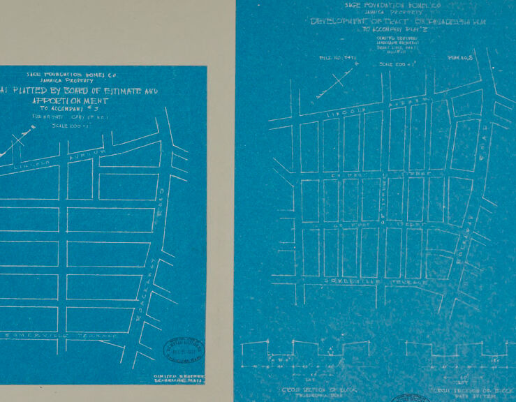
This image shows two map-like blueprints placed side by side on a neutral gray background. The blueprints are in blue with white markings and text. They appear to be planning documents for urban development or property designation, specifically outlining streets and blocks within a defined area.
Left side blueprint: Shows a smaller grid-like design with labeled streets such as "Lincoln Avenue," "Somerville Terrace," and other street names. The text at the top mentions "Platted by Board of Estimate and Apportionment" and includes words like "Map Prosecution Works Co." and "Jamaica Property." The scale is marked "200 ft."
Right side blueprint: Depicts a similar but larger grid layout. The text references "Development of Project Demolished Slum." Streets are labeled in a block arrangement, and some architectural or infrastructure details are sketched. It includes similar identifying text at the top.
Both blueprints bear stamps at the bottom, and the layouts appear to document urban planning efforts, likely specific to Jamaica or nearby areas.
Created by gpt-4o-2024-08-06 on 2025-06-09
The image shows a blueprint depicting two development plans by the Sage Foundation Homes Company for the Jamaica property area. The blueprints detail the street layout and block arrangements within the development. Both plans are laid out on a muted grayish background.
On the left, the blueprint is titled "As Platted by Board of Estimate and Apportionment to Accompany Map 3." It shows a layout of several parallel streets intersected by perpendicular cross streets, with street names such as "Lincoln" and "Somerville Terrace" clearly marked.
On the right, another blueprint is labeled "Development General Plan Clarendon Hills Map to Accompany Map 2." This map is denser, featuring more blocks and streets, suggesting a more detailed development plan. Some street names are visible, and there is a portion labeled with a protractor-like arc, indicating some planned measurements or angles.
Each blueprint includes a legend featuring a scale, a "True North" arrow indication, and an official seal/stamp indicating validation by the Sage Foundation Homes Company.
Anthropic Claude
Created by anthropic.claude-3-haiku-20240307-v1:0 on 2025-06-13
The image appears to be a set of two detailed maps or blueprints. The map on the left shows a grid-like layout of streets and blocks, likely representing a city or neighborhood plan. The map on the right is a more expansive view of a larger area, also displaying a grid-like pattern of streets and blocks. Both maps are presented in a blue-tinted color scheme, suggesting they are blueprints or architectural drawings. The maps do not contain any human faces or identifiable individuals, so I will refrain from discussing or identifying any people in the image.
Created by us.anthropic.claude-3-opus-20240229-v1:0 on 2025-06-13
The image shows two blueprint diagrams side-by-side. The diagrams appear to depict maps or plans for some kind of urban development or construction project, likely related to housing or residential buildings based on the grid-like layout of rectangular shapes that resemble building footprints or lots.
The blueprint on the left has a title indicating it is a "TENTATIVE SKETCH OF JAMAICA PROPERTY" to accompany some proposal. The blueprint on the right has a similar title mentioning a "DEVELOPMENT DISTRICT OF PHILADELPHIA, PA."
Both blueprints show street names, block numbers, and other annotations providing details about the mapped out areas and proposed plans. The grid-like arrangements of rectangles suggest these are maps laying out streets and individual building sites or housing units in an organized, planned development.
The blueprints have a distinct blue color with white lines and text, which is characteristic of the cyanotype process used historically for duplicating architectural and engineering drawings. The aged, slightly worn appearance of the paper implies these are older plans, likely from the early-to-mid 20th century based on the drawing style and titling.
Created by us.anthropic.claude-3-5-sonnet-20241022-v2:0 on 2025-06-13
This image shows two architectural or urban planning blueprints with a cyan/blue background and white lines. They appear to be street maps or development plans for what seems to be a neighborhood or district. Both blueprints show a grid pattern of streets and blocks, with the one on the left being slightly simpler in layout compared to the one on the right. The right blueprint also includes what appears to be some cross-sectional drawings at the bottom. Both documents have titles at the top, though they're somewhat difficult to read in this reproduction, and they appear to be official planning documents with scale measurements included. The blueprints are mounted on a light gray or beige background, suggesting this might be a scan or photograph of archived planning documents.
Meta Llama
Created by us.meta.llama3-2-11b-instruct-v1:0 on 2025-06-10
The image presents two blue maps on a beige background, each with white lines and text. The maps are likely architectural or urban planning documents, showcasing the layout of a specific area or development.
Map 1:
- Located on the left side of the image
- Features a grid-like pattern with rectangular blocks and roads
- Includes text at the top, which appears to be a title or header
- Additional text is scattered throughout the map, possibly indicating property boundaries or other relevant information
- A circular stamp is visible in the bottom-left corner
Map 2:
- Positioned on the right side of the image
- Displays a more complex layout with curved roads and irregularly shaped blocks
- Similar to Map 1, it features a title or header at the top and additional text throughout
- A circular stamp is also present in the bottom-right corner
Background:
- The beige background provides a neutral contrast to the blue maps
- It may be a scan or photocopy of an original document, as evidenced by the slight yellowing and creasing around the edges
Overall:
- The image suggests that these maps are part of a larger collection or archive related to urban planning or architecture
- The use of blue paper and white ink creates a clear and legible visual representation of the layouts
- The presence of stamps and text implies that these maps have been officially approved or sanctioned by relevant authorities.
Created by us.meta.llama3-2-90b-instruct-v1:0 on 2025-06-10
The image presents two blueprints of a neighborhood, likely from the early 20th century, given the style and content. The blueprints are set against a beige background, with the left one being smaller and the right one larger.
Left Blueprint:
- Title: "SAGE FOUNDATION HOMES CO. JAMAICA, QUEENS, N.Y."
- Subtitle: "A. PLATTED BY BOARD OF ESTIMATE AND APPORTIONMENT TO ACCOMPANY *3"
- Scale: 1/8" = 1' (Scale 200 ft.)
- Content: The blueprint features a grid-like pattern of streets and lots, with some buildings and structures marked. It appears to be a plan for a residential development.
Right Blueprint:
- Title: "SAGE FOUNDATION HOMES CO. JAMAICA, QUEENS, N.Y."
- Subtitle: "DEVELOPMENT OF TRACT IN COLLEGE POINT TO ACCOMPANY PLAN 2"
- Scale: 1/8" = 1' (Scale 200 ft.)
- Content: This blueprint shows a more detailed plan of the neighborhood, with individual buildings and lots labeled. It includes information about the size and shape of the lots, as well as the location of streets and other features.
Additional Features:
- Stamps: Both blueprints have stamps in the bottom-left corner, which appear to be from the New York City Department of Buildings.
- Handwritten Notes: There are handwritten notes on both blueprints, which provide additional information about the plans and the development.
Overall, the image suggests that the blueprints were created as part of a larger project to develop a residential neighborhood in Jamaica, Queens. The level of detail and the inclusion of stamps and handwritten notes indicate that these plans were likely used for official purposes, such as obtaining building permits or approvals from local authorities.
Amazon Nova
Created by amazon.nova-lite-v1:0 on 2025-06-05
The image features two architectural blueprints, both printed on blue paper. The left blueprint is titled "SITE PLANNING HOMES CO. AS PLATTED BY BOARD OF ESTIMATE AND TO ACCEPTANCE" and includes a scale of 100 feet. The right blueprint is titled "STAGE POWER BOWLES DEVELOPMENT OR PROPERTY TO ACCORDANCE PLAN" and includes a scale of 100 feet. Both blueprints include a variety of lines, measurements, and annotations that are typical of architectural plans. The blueprints are bordered by a beige background.
Created by amazon.nova-pro-v1:0 on 2025-06-05
The image shows two blueprints or architectural plans on a blue background. The blueprints are printed on a light blue background, with white lines and text. The blueprints show the layout of a building or structure, with different rooms and areas labeled. The text on the blueprints includes measurements, room names, and other details. The image is likely a technical drawing or plan used for construction or renovation purposes.
Google Gemini
Created by gemini-2.0-flash-lite on 2025-05-01
Here's a description of the image:
Overall Impression:
The image appears to be a blueprint or technical drawing. It features two sections, both showing street layouts. The predominant color is blue, likely the background of the original blueprint. The lines are white.
Left Section:
- Displays a street layout labeled with street names like "Lincoln," "Avium," "Somerville Terrace," and "Road."
- Contains text related to the project's origins, including a reference to the "Sage Foundation Homes Co" and the "Board of Estimate and Apportionment".
Right Section:
- Also details a street layout, with street names like "Lincoln", "Avium", and "Somerville Terrace."
- Contains labels such as "Development of tract on Philadelphia Ave to Accompany Plan Z,".
- Includes "Cross Section of Block, Philadelphia side" and a "Cross Section of Block, East Sider" showing dimensions.
General Characteristics:
- The text on both sections is hand-drawn or lettered, typical of blueprints.
- There are circular stamps on the blueprints indicating a seal or official approval.
- The image is against a neutral gray background.
Possible Context:
Based on the "Sage Foundation Homes Co" and references to plotting and the Board of Estimate, this blueprint may represent a planned development or subdivision layout. It seems to be a historical document, possibly from the early to mid-20th century. The labels like "Philadelphia Ave" would indicate the planned development location.
Created by gemini-2.0-flash on 2025-05-01
The image shows two blueprints on a light gray background. The blueprints are a bright blue color, with white lines and text. Both blueprints depict street layouts in a neighborhood, likely for development or planning purposes.
The blueprint on the left is labeled "SAGE POUNDATION HOMES CO, JAMAICA PROPERTY, AS PLATTED BY BOARD OF ESTIMATE AND APPORTIONMENT TO ACCOMPANY". It features streets such as "Lincoln Avenue," "Amius Avenue," "Roachawk Road," and "Somerville Terrace." The scale is noted as "SCALE 200' 1''."
The blueprint on the right is labeled "SAGE POUNDATION HOMES CO, JAMAICA PROPERTY, DEVELOPMENT OF TRACT ON PHILADELPHIA PLAN TO ACCOMPANY PLAN 2". This blueprint shows a more detailed street layout, with named streets such as "Lincoln Avenue," "Andrew Avenue," and "Somerville Terrace." A cross-section of a block is also provided at the bottom. File number is labeled as "FILE NO 5471"
and "PIAN N.O. 8". Scale is noted as "SCALE 200' 1''".
Overall, the image presents technical drawings related to real estate development or urban planning. The style suggests they are older documents, likely from the mid-20th century or earlier.
Mistral Pixtral
Created by us.mistral.pixtral-large-2502-v1:0 on 2025-06-04
The image shows two blueprints, which are architectural or engineering drawings. Both blueprints are on blue-colored paper with white lines, typical of traditional blueprint reproduction methods. Here is a detailed summary of each blueprint:
Left Blueprint:
- Title and Description: The title reads "Tace Production Dome Co. Plot Plan of Estimate and Approximate Cost to Company."
- Date: The blueprint is dated January 27, 1961.
- Content: The drawing appears to be a plot plan, likely showing the layout of a building or structure. It includes various labeled sections and measurements, indicating different parts of the structure or areas within a site.
- Scale: The scale is indicated as 1" = 20'.
- Additional Information: There is a stamp or seal at the bottom right corner, which likely belongs to the engineering or architectural firm that created the blueprint.
Right Blueprint:
- Title and Description: The title reads "Tace Production Homes Development or Tract on Philadelphia Ave. to Lombard St."
- Date: The blueprint is dated January 27, 1961.
- Content: This drawing seems to be a more detailed plan, possibly showing the development layout of a tract of land. It includes multiple labeled sections, which could represent different plots, buildings, or areas within the development.
- Scale: The scale is indicated as 1" = 20'.
- Additional Information: There is a stamp or seal at the bottom right corner, similar to the left blueprint, indicating the firm responsible for the drawing. There is also a note at the bottom left corner mentioning a "Copy Section of Block Philadelphia 1961."
Both blueprints are detailed technical drawings used for planning and construction purposes, providing essential information about the layout and dimensions of the respective projects.
Qwen
Created by Qwen/Qwen2.5-VL-7B-Instruct on 2025-07-16
The image shows two blueprints, both on a beige background. The blueprints appear to be architectural or land development plans, as indicated by the text and layout.
The left blueprint is labeled "JACK FORTNIGHT HOMESI CO. JAMAICA PROPERTY" and has additional text that includes "AI. PLATTED BY BOARD OF ESTIMATE AND APPLICATIONMENT TO ACCOMPANY #3." It includes a scale note at the bottom: "1" to 400'. There are several labeled streets and lines indicating property boundaries or structures.
The right blueprint is labeled "JACOB FORTNIGHT HOMESI JAMAICA PROPERTY DEVELOPMENT OR TENTH CHICAGO AVENUE TO ACCOMPANY PLAN #2." It includes a scale note at the bottom: "1" to 240'. It contains a grid layout with labeled streets and buildings, suggesting a detailed plan for land development, possibly for residential or commercial purposes. There are also notes and measurements on the blueprint.
Both blueprints are detailed and appear to be part of a larger land development project, possibly for a housing community.
Created by Qwen/Qwen2.5-VL-72B-Instruct on 2025-07-16
This image shows two blueprints side by side, both laid out on a light gray background. Here is a detailed description of each:
Left Blueprint:
- Title: "Jamaica Property - AS PLATTED BY BOARD OF ESTIMATE AND APPORTIONMENT TO ACCOMPANY [ILLEGIBLE]."
- Content: This blueprint appears to depict a planned layout of property blocks or lots, likely for housing or urban development. The design is grid-like, with rectangular blocks arranged in neat rows and columns, suggesting a structured urban plan.
- Details: There are street names or labels on the edges, and a scale is indicated at the bottom left corner. There is also a stamp or seal in the bottom right corner, possibly from an official agency.
Right Blueprint:
- Title: "Jamaica Property - DEVELOPMENT OR STREET ORIENTATION TO ACCOMPANY PLANS."
- Content: This blueprint also shows a planned layout of property blocks or lots. The design is similar to the left blueprint but with some differences in the arrangement of the blocks and the presence of additional details.
- Details: There are street names or labels on the edges, and a scale is indicated at the bottom left corner. There is also a stamp or seal in the bottom right corner, possibly from an official agency. The bottom part of this blueprint includes a cross-section of a block, showing the elevation and possibly the depth of the lots.
Both blueprints are related to the planning and development of property in Jamaica, likely for urban or residential use. The detailed layout and the presence of official stamps suggest that these plans were part of a formal urban development project.
Text analysis
Amazon