Machine Generated Data
Tags
Color Analysis
Feature analysis
Amazon
Clarifai

Clarifai
| Poster | 56.3% | |


Categories
Imagga
created on 2019-06-05
| text visuals | 97.4% | |
| paintings art | 1.4% | |
| streetview architecture | 1.1% | |
Captions
Microsoft
created by unknown on 2019-06-05
| a close up of text on a white background | 76.4% | |
| a close up of text on a black background | 71.4% | |
| a close up of text on a white surface | 71.3% | |
Clarifai
No captions written
Salesforce
Created by general-english-image-caption-blip on 2025-05-18
a photograph of a map of a plan of a building with a map of the area
Created by general-english-image-caption-blip-2 on 2025-07-06
a map of the area of the city of london
OpenAI GPT
Created by gpt-4o-2024-11-20 on 2025-06-13
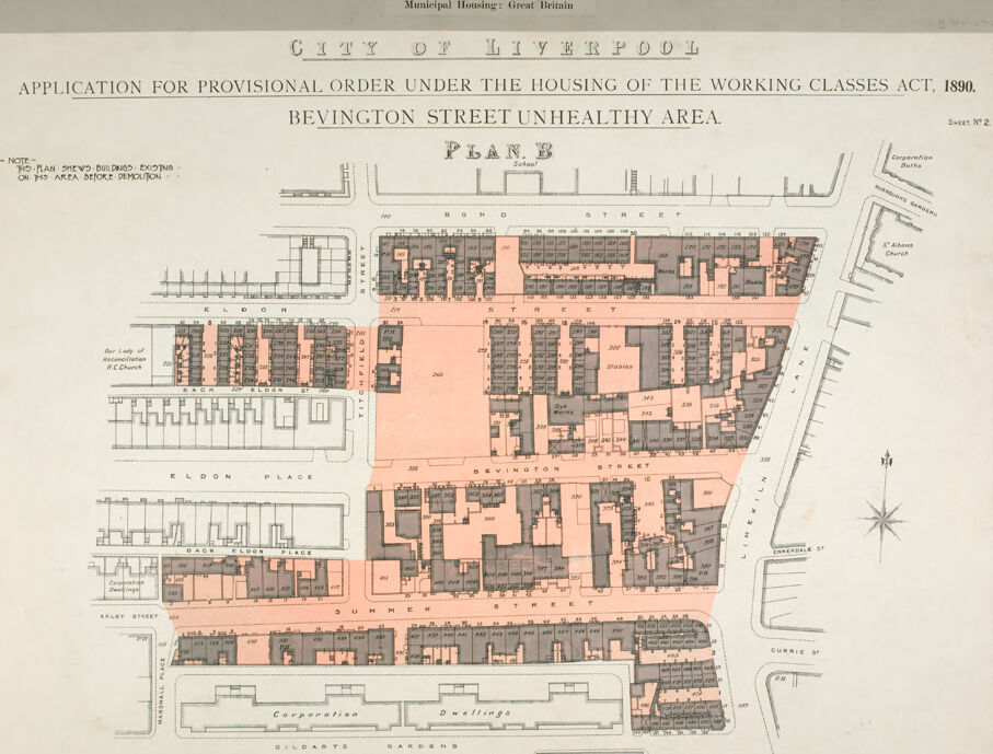
This image is a historic urban planning map titled "Application for Provisional Order Under the Housing of the Working Classes Act, 1890," specifically highlighting the Bevington Street unhealthy area in Liverpool. It was created in reference to housing reform and municipal efforts to improve living conditions.
The map is labeled at the top with "City of Liverpool" and includes details about the application under the 1890 act. The outlined area, shaded in pink, indicates the buildings and plots considered "unhealthy" or substandard according to the act.
Prominent streets like Bevington Street, Eldon Street, Eldon Place, Arley Street, and the surrounding streets are noted, showing the arrangement of housing blocks and structures. The map also includes architectural details of buildings slated for demolition or redevelopment. A compass rose is situated toward the lower right, indicating orientation. Churches, school buildings, and open spaces, such as Corporation Dwellings and Gildarts Gardens, are also marked.
The purpose of this map seems to be to document areas in need of intervention due to poor living conditions as part of housing reform during the late 19th century in Liverpool.
Created by gpt-4o-2024-08-06 on 2025-06-13
The image is a historical map from the City of Liverpool titled "Application for Provisional Order Under the Housing of the Working Classes Act, 1890: Bevington Street Unhealthy Area, Plan B." It is dated to the late 19th century and appears to be part of an application or study regarding housing conditions.
The map shows a detailed layout of streets and buildings in the Bevington Street area of Liverpool. The area has been marked out with different sections shaded in pink, indicating the buildings existing on site before demolition as noted by the text on the map. Various streets are labeled, including Eldon Street, Bevington Street, Prince Edwin Street, and Arley Street. Surrounding features like schools, churches, and corporation dwellings are also indicated.
The map includes a compass rose pointing north for orientation. The area is referenced as an "unhealthy area," suggesting it may be subject to measures under the Housing of the Working Classes Act of 1890, which aimed to improve living conditions in urban areas. The document reflects concerns about urban housing and public health during the time period.
Anthropic Claude
Created by anthropic.claude-3-haiku-20240307-v1:0 on 2025-06-17
This image appears to be a detailed plan or map of the Bevington Street unhealthy area in the city of Liverpool, Great Britain. The map shows the layout of the buildings, streets, and other structures in this urban area. The plan is labeled "Plan B" and provides an "Application for Provisional Order under the Housing of the Working Classes Act, 1890" for this specific location. The map includes various annotations and labels identifying different features of the area.
Created by us.anthropic.claude-3-opus-20240229-v1:0 on 2025-06-17
The image shows a detailed architectural plan titled "Application for Provisional Order under the Housing of the Working Classes Act, 1890" for the "Bevington Street Unhealthy Area" in Liverpool, Great Britain. The plan depicts the layout of several residential blocks, with individual dwelling units, common areas like courtyards, and surrounding streets clearly marked. A compass rose indicates the orientation, and a scale is provided. The level of detail suggests this was an official municipal housing plan submitted to address poor living conditions in that neighborhood under late 19th century British housing reform legislation.
Created by us.anthropic.claude-3-5-sonnet-20241022-v2:0 on 2025-06-17
This is a historical urban planning map titled "City of Liverpool - Application for Provisional Order Under the Housing of the Working Classes Act, 1890" for the Bevington Street Unhealthy Area. It's labeled as "Plan B" and appears to be a detailed architectural site plan showing building footprints and street layouts.
The map uses a color scheme where existing buildings are shown in gray/black, and what appears to be proposed demolition or redevelopment areas are highlighted in pink/salmon color. The plan shows several streets including Bond Street, Bevington Street, and Summer Street, with detailed building plots and property boundaries clearly marked.
The layout reveals a dense urban environment typical of late Victorian working-class housing, with rows of terraced houses and back-to-back dwellings. At the bottom of the plan, there are "Corporation Buildings" shown, suggesting municipal ownership or development.
This document represents an important piece of social history, demonstrating early attempts at urban renewal and public health improvement in industrial Britain. The designation as an "unhealthy area" indicates this was likely part of a slum clearance or housing improvement scheme common in British cities during this period.
Meta Llama
Created by us.meta.llama3-2-11b-instruct-v1:0 on 2025-06-11
The image presents a map of the City of Liverpool, specifically highlighting the Bevington Street Unhealthy Area. The map is titled "Application for Provisional Order Under the Housing of the Working Classes Act, 1890" and features a key at the top that reads "Municipal Housing: Great Britain."
Here is a detailed breakdown of the map's components:
- Title: The title is prominently displayed at the top of the map, providing context for the application.
- Text: "Application for Provisional Order Under the Housing of the Working Classes Act, 1890."
- Font: Black, serif font
- Size: Large, bold font
- Key: The key is located at the top right corner of the map and provides information about the symbols and colors used on the map.
- Text: "Municipal Housing: Great Britain"
- Font: Small, sans-serif font
- Size: Small font
- Map: The map itself is a detailed illustration of the Bevington Street Unhealthy Area, showing the layout of buildings, streets, and other features.
- Color scheme: The map features a range of colors, including pink, gray, and black, to represent different types of buildings and areas.
- Symbols: Various symbols are used on the map to indicate different features, such as buildings, streets, and parks.
- Legend: The legend is located at the bottom left corner of the map and provides a key to the symbols and colors used on the map.
- Text: "Note - The Plan shows Buildings - existing on the Area before Demolition"
- Font: Small, sans-serif font
- Size: Small font
In summary, the image presents a detailed map of the Bevington Street Unhealthy Area in Liverpool, highlighting the layout of buildings, streets, and other features. The map is accompanied by a key and legend that provide context and explain the symbols and colors used.
Created by us.meta.llama3-2-90b-instruct-v1:0 on 2025-06-11
This image is a map of the City of Liverpool, specifically the Bevington Street Unhealthy Area. The map is titled "Application for Provisional Order Under the Housing of the Working Classes Act, 1890." It features a detailed layout of the area, with buildings and streets labeled. The map also includes a key or legend that explains the different symbols and colors used to represent various features.
The map appears to be a historical document, likely created in the late 19th or early 20th century. It provides valuable information about the urban planning and development of Liverpool during that time period. The map's title suggests that it was used as part of an application for a provisional order related to housing and public health in the area.
Overall, this image is a fascinating piece of historical cartography that offers insights into the past of Liverpool and its urban development.
Amazon Nova
Created by amazon.nova-lite-v1:0 on 2025-06-06
The image is a map titled "City of Liverpool" from 1890. It depicts a specific area within the city, focusing on an unhealthy area called Bevington Street. The map includes a detailed plan of the area, showing the layout of buildings, streets, and other structures. The map is divided into sections, with each section representing a different part of the area. The map also includes a scale of feet at the bottom, indicating the size of the area. The map is part of an application for a provisional order under the Housing of the Working Classes Act, 1890, which aimed to improve housing conditions for the working class in the city of Liverpool.
Created by amazon.nova-pro-v1:0 on 2025-06-06
The image is a detailed architectural plan titled "City of Liverpool: Application for Provisional Order under the Housing of the Working Classes Act, 1890. Bevington Street Unhealthy Area." The plan is labeled as "Plan B" and includes a note about the demolition of buildings in the area. The document is part of a series of plans numbered "Sheet No. 2."
The plan is divided into a grid with various buildings and streets marked. The primary focus is on Bevington Street, which is highlighted in pink, indicating it as the "unhealthy area." The plan shows a mix of residential and commercial buildings, with detailed annotations of the structures, including their dimensions and types.
Key features of the plan include:
- Buildings marked in different colors, likely indicating different types or conditions.
- Streets and pathways are clearly delineated, with names such as Bevington Street, Eldon Place, and others.
- A compass rose in the bottom right corner indicates the orientation of the plan.
- Scale of feet is provided at the bottom, allowing for accurate measurement of the structures and spaces.
- Notes and labels provide additional information about specific buildings and areas, such as "Our Lady of Reconciliation R.C. Church" and "Corporation Dwellings."
The plan is a comprehensive representation of the area, designed to inform decisions regarding the redevelopment and improvement of the housing conditions in the specified unhealthy area.
Google Gemini
Created by gemini-2.0-flash on 2025-06-02
Here's a description of the image based on the OCR text and visual details:
The image is a map titled "APPLICATION FOR PROVISIONAL ORDER UNDER THE HOUSING OF THE WORKING CLASSES ACT, 1890. BEVINGTON STREET UNHEALTHY AREA." It's designated as "SHEET N° 2" and labelled "PLAN B". The city in question is "CITY OF LIVERPOOL". The map shows a detailed layout of streets and buildings in the Bevington Street area. Some buildings are shaded or colored in, potentially indicating their condition or status in relation to the "unhealthy area" designation. A note mentions that the plan shows buildings existing on the area before demolition. There's also a "SCALE OF FEET" included for reference.
Created by gemini-2.0-flash-lite on 2025-06-02
This is a historical map or architectural plan of the Bevington Street Unhealthy Area in Liverpool, England. It's part of an application for a provisional order under the Housing of the Working Classes Act of 1890.
Here's a breakdown:
- Title: "Application for Provisional Order under the Housing of the Working Classes Act, 1890. Bevington Street Unhealthy Area. Plan B."
- Scale: Indicates a scale of feet, allowing for measurement and understanding of the size of the area.
- Streets: The map highlights several streets including Bond Street, Eldon Street, Titchfield Lane, Back Eldon Street, Eldon Place, Apley Street, Back Eldon Place, Summer Street, Limekiln Lane, and Currie Street.
- Buildings/Structures: The map shows the layout of buildings, with individual structures numbered (e.g., 257, 259, 357, etc.). It also indicates the presence of "Corporation Dwellings", a school, a church (St. Albans Church), and "Stables".
- Color Coding: A specific area (the "Unhealthy Area") is highlighted with a pink/orange color.
- Annotations: Various annotations are present to clarify elements on the map, such as "Our Lady of Reconciliation RC Church" and "Corporation Dwellings".
The image is a valuable historical document reflecting urban planning and housing conditions in Liverpool during the late 19th century, particularly concerning the housing of the working classes and efforts to address unhealthy areas.
Mistral Pixtral
Created by us.mistral.pixtral-large-2502-v1:0 on 2025-06-05
The image is a historical map titled "Municipal Housing: Great Britain," specifically focusing on the "City of Liverpool." It is an application for a provisional order under the Housing of the Working Classes Act, 1890, addressing the "Bevington Street Unhealthy Area."
Key details of the map include:
Title and Context:
- The map is labeled "Plan B" and is part of a series (Sheet No. 2).
- It aims to show buildings existing in the area designated for smoke deflection.
Geographical Details:
- The map covers an area around Bevington Street, including surrounding streets such as Bond Street, Eloon Place, Arley Street, Summer Street, Corporation Street, and others.
- Notable landmarks include "Our Lady of Reconciliation R.C. Church."
- The map also marks "St. John's Gardens" and "Gildart's Gardens."
Layout and Structures:
- The map is color-coded with buildings highlighted in pink.
- It provides a detailed layout of the buildings and streets in the designated unhealthy area.
- The map includes a scale for reference, indicating the size and proportion of the depicted area.
Purpose:
- The map is likely used for urban planning and public health purposes, aiming to address and improve the living conditions in the specified unhealthy area under the provisions of the Housing of the Working Classes Act, 1890.
Overall, the map serves as a historical document illustrating the urban landscape of Liverpool during the late 19th century, highlighting areas targeted for improvement due to health and sanitation concerns.
Qwen
Created by Qwen/Qwen2.5-VL-7B-Instruct on 2025-07-16
This image is a historical map titled "City of Liverpool: Application for Provisional Order Under the Housing of the Working Classes Act, 1890. Bevington Street Unhealthy Area. Plan B." The map is a detailed cadastral plan that shows the layout of buildings and streets in the area of Bevington Street. It marks the existing buildings, indicating areas that are unhealthy and in need of improvement or demolition as part of the provisions made under the Housing of the Working Classes Act of 1890.
The map is divided into sections, with buildings labeled and numbered, and some areas are shaded in pink, which likely indicates areas that are designated for demolition or improvement under the act. The map also includes labels for key streets and landmarks, such as "Our Lady of Walsingham R.C. Church" and "Corporation Baths," which are prominent features in the vicinity of the Bevington Street area.
The map is a valuable historical document for studying the socio-economic conditions and urban planning practices of the late 19th century in Liverpool. It provides insight into the efforts to improve living conditions for the working classes, particularly focusing on removing unhealthy and substandard housing from the city.
Created by Qwen/Qwen2.5-VL-72B-Instruct on 2025-07-16
This image is a historical map titled "City of Liverpool: Application for Provisional Order under the Housing of the Working Classes Act, 1890 - Bevington Street Unhealthy Area." It is labeled as "Plan B" and is part of "Sheet N°2." The map is related to municipal housing in Great Britain.
The map shows a detailed layout of a specific area in Liverpool, with streets and buildings marked. The title notes that this plan shows buildings existing prior to the clearance of the area. The map includes street names such as Bond Street, Eldon Street, Eldon Place, Bevington Street, Summer Street, and others. There are also references to specific locations like "Our Lady of Mount Carmel R.C Church" and "St. Alban's Church."
The map highlights an area shaded in pink, indicating the "unhealthy area" that was targeted for improvement under the housing act. Various building types and structures are depicted, including "Corporation Dwellings" and "Gildarts Gardens."
A scale of feet is provided at the bottom of the map, allowing for the measurement of distances. The overall layout and design suggest that this map was used for planning and documenting the urban renewal efforts in the specified area of Liverpool.
Text analysis
Amazon