Machine Generated Data
Tags
Color Analysis
Feature analysis
Amazon
Clarifai
AWS Rekognition
| Bird | 84.1% | |


Categories
Imagga
created on 2019-06-05
| paintings art | 100% | |
Captions
Microsoft
created by unknown on 2019-06-05
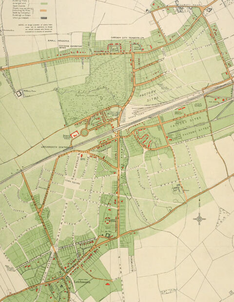
| a close up of a map | 75.3% | |
| close up of a map | 71.4% | |
| a map with text | 62.9% | |
Clarifai
No captions written
Salesforce
Created by general-english-image-caption-blip-2 on 2025-07-06
a map of the town of london, with the streets and roads
Created by general-english-image-caption-blip on 2025-05-03
a photograph of a map of a map of a city
OpenAI GPT
Created by gpt-4o-2024-11-20 on 2025-06-07
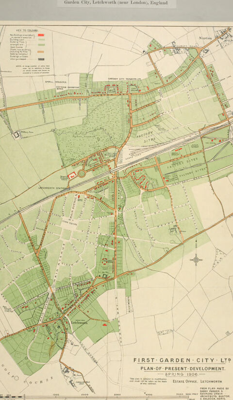
The image is a historical map of Letchworth Garden City, located near London, England. The map is titled "First Garden City Ltd. Plan of Present Development Spring 1906." It displays the layout of the town with a focus on its urban planning and green spaces.
The map uses distinct colors to indicate various zones, as explained in the legend on the top-left corner. For example:
- Green areas denote open spaces, parks, or agricultural land.
- Red markings highlight specific buildings, estate developments, or industrial areas.
- Yellow patches represent residential areas.
The map is detailed and shows roads, pathways, railway lines, and landmarks like "Factory Area" and "Letchworth Station." It provides an organized overview of the Garden City concept, emphasizing planned development around sustainability, nature, and balanced urban expansion.
Framing the map is a gray border with its title printed at the top: "Garden City, Letchworth (near London), England." The map edges show signs of wear, with some tears, giving it an antique appearance.
Created by gpt-4o-2024-08-06 on 2025-06-07
The image is a historical map titled "Garden City, Letchworth (near London), England" from the early 20th century. It is a "Plan of Present Development" for spring 1906, created by First Garden City Ltd. The map is colored, with various shades indicating different types of land use and development, such as residential areas, public buildings, and factory sites. A key at the top left corner explains the color coding and symbols used within the map. The map displays the layout of streets, lots, and open spaces intended for the garden city development concept. There is a specific focus on planned areas, highlighting the incorporation of green spaces and the organized structure typical of garden cities. The map is enclosed within a gray border, and the edges of the paper show signs of wear, suggesting it is an old document.
Anthropic Claude
Created by anthropic.claude-3-haiku-20240307-v1:0 on 2025-06-12
The image appears to be a map of Garden City, Letchworth near London, England. It is titled "First Garden City, Ltd. Plan of Present Development, Spring 1906". The map shows the layout of the town, including streets, buildings, and land parcels. It provides details about the development and planning of this planned community, which was one of the earliest examples of a garden city in England.
Created by us.anthropic.claude-3-5-sonnet-20241022-v2:0 on 2025-06-12
This is a historical map showing the "First Garden City Ltd" plan of development in Letchworth near London, England from Spring 1906. The map displays an early layout of Letchworth Garden City, which was one of the first planned garden cities in the world. The map uses a color scheme of pale greens and creams, with red lines indicating roads and development areas. The layout shows the characteristic garden city planning principles with generous green spaces integrated throughout the urban development. There are clear divisions between residential, industrial, and public spaces, with curved streets and plenty of parks and open areas marked in green. The map includes a compass rose and scale, and appears to be drawn from the Estate Office in Letchworth. This is an important historical document as it represents one of the earliest examples of garden city urban planning, a movement that would go on to influence town planning throughout the 20th century.
Meta Llama
Created by us.meta.llama3-2-11b-instruct-v1:0 on 2025-05-25
The image depicts a map of Garden City, Letchworth, near London, England, titled "First Garden City Ltd Plan of Present Development Spring 1906." The map is presented on a light gray background with a white border and features a green and beige color scheme. It includes various symbols and markings to represent different types of land use, such as roads, buildings, and parks.
- Map Title
- The title is displayed at the top of the map in black text.
- It reads "First Garden City Ltd Plan of Present Development Spring 1906."
- Map Legend
- The legend is located in the top-left corner of the map.
- It explains the symbols used on the map to represent different types of land use.
- Map Features
- The map shows the layout of the city, including roads, buildings, and parks.
- It also includes symbols to represent different types of land use, such as residential areas, commercial areas, and open spaces.
- Color Scheme
- The map features a green and beige color scheme.
- Green is used to represent open spaces and parks, while beige is used to represent built-up areas.
- Border
- The map has a white border around it.
- The border is slightly torn in some places, giving the map a worn and aged appearance.
- Background
- The background of the image is light gray.
- It provides a neutral backdrop for the map and helps to highlight its features.
Overall, the image provides a detailed and informative view of Garden City, Letchworth, near London, England, in 1906. The map's color scheme and symbols help to clearly represent different types of land use, making it easy to understand the layout of the city.
Created by us.meta.llama3-2-90b-instruct-v1:0 on 2025-05-25
The image depicts a map of Letchworth, England, specifically highlighting the area known as Garden City. The map is presented in a sepia tone and features a key to colors, which explains the different shades used to represent various elements on the map.
Key to Colors:
- Red: Indicates roads
- Green: Represents parks and open spaces
- Yellow: Denotes buildings and structures
- Black: Outlines boundaries and roads
Map Features:
- The map shows the layout of Garden City, including its roads, parks, and buildings.
- It also highlights the location of important landmarks, such as the railway station and the town center.
- The map provides a detailed view of the area, allowing viewers to understand the layout and organization of Garden City.
Historical Significance:
- The map is likely from the early 20th century, given the style and content of the map.
- It may have been created as part of a planning or development project for Garden City.
- The map provides valuable insight into the history and development of Letchworth, England.
Overall, the image presents a detailed and informative map of Garden City, Letchworth, England. It offers a unique glimpse into the history and development of the area, and provides valuable information for researchers and historians.
Amazon Nova
Created by amazon.nova-pro-v1:0 on 2025-05-25
The image is a historical map of Garden City, Letchworth, near London, England, titled "Plan of Present Development." The map is printed on paper and appears to be an old document, possibly from the early 20th century. The map is bordered by a white frame and is surrounded by a gray background.
The map depicts the layout of Garden City, with various sections and areas marked in different colors. The key to the colors is provided in the top left corner of the map, with red, green, and brown indicating different types of land use or development. The map also includes a compass rose in the bottom right corner, indicating the orientation of the map.
The map shows a grid-like pattern of streets and roads, with buildings and other structures marked in red. The buildings are of different sizes and shapes, indicating different types of structures, such as houses, factories, and commercial buildings. The map also includes a railway line running through the city, with stations marked in red.
Overall, the map provides a detailed view of the layout and development of Garden City, Letchworth, near London, England, in the early 20th century. It shows the different types of land use and development, as well as the infrastructure and transportation networks that supported the city's growth.
Created by amazon.nova-lite-v1:0 on 2025-05-25
This is a map of Garden City, Letchworth, England, published in 1906. The map is titled "Plan of Present Development" and is accompanied by a key that explains the different colors used to represent various types of buildings and structures. The map shows the layout of the city, including the streets, parks, and other features. The map also includes a legend that explains the symbols used to represent different types of buildings, such as factories, cottages, and houses. The map is a valuable historical document that provides insight into the development of Garden City, Letchworth, and the planning and design principles that were used to create the city.
Google Gemini
Created by gemini-2.0-flash-lite on 2025-04-29
Here's a description of the image:
The image is a historical map titled "First Garden City Ltd: Plan of Present Development, Spring 1906." It is a map of Letchworth, a garden city located near London, England.
Key Features:
- Color Scheme: The map uses a color-coded system to differentiate areas, with greens likely indicating developed or planned residential areas, and the pale orange/brown lines, representing roadways.
- Features: The map highlights key features of the city, including:
- Letchworth Station
- Factory Sites
- Garden City Tenants Ltd
- Small Meadows
- Cottage Exhibition Site
- A golf course
- Scale: A scale bar is included at the bottom.
- Text: There are various labels for the city's infrastructure and areas. The title and other descriptive text give historical context.
- Condition: The map appears to be aged, showing wear and tear, suggesting its age.
Overall Impression:
The map provides a snapshot of Letchworth's development in 1906, reflecting the principles of the garden city movement, with its emphasis on integrating residential areas with green spaces and industry. It's a valuable historical document for understanding urban planning concepts.
Created by gemini-2.0-flash on 2025-04-29
Here's a description of the image:
The image is a historical map of "Garden City, Letchworth (near London), England". The map is titled "FIRST GARDEN CITY LTD, PLAN OF PRESENT DEVELOPMENT. SPRING 1906-" and indicates it's from the "ESTATE OFFICE, LETCHWORTH". It's set against a grey background.
The map itself is detailed, showing the layout of the area with different land usages indicated by a key to colors. It highlights areas designated for buildings erected or in process of construction, building sites, open spaces, private gardens, roads existing or in process of construction, roads by-passing the estate, and other purposes.
The layout consists of a grid-like pattern of streets and roads, with green areas representing open spaces, likely parks, or fields. Certain areas are labeled, like "Letchworth Station" and "Golf Course." There are also areas marked as "Factory Sites." The roads are depicted with a reddish-brown color. The location of "Norton" is also marked. The map also includes a scale for distance.
Mistral Pixtral
Created by us.mistral.pixtral-large-2502-v1:0 on 2025-05-25
The image is a historical map titled "First Garden City Ltd: Plan of Present Development," dated October 1922. It depicts the layout of Letchworth Garden City, located near London, England. The map includes a key to various symbols used, indicating different types of land use and infrastructure:
- Red represents existing buildings.
- Green denotes allotments.
- Yellow signifies industrial areas.
- Brown indicates areas under cultivation.
- Black shows areas where building operations are in progress.
- Dotted lines represent proposed roads.
The map highlights key locations within the Garden City, such as the town center, factories, and residential areas. It also includes a scale and a compass rose for orientation. The map was printed by the Estate Office in Letchworth from a plan made by Louis de Soissons, ARIBA, and printed by Waterlow & Sons Limited in London and Watford.
Letchworth Garden City was one of the first garden cities, planned to combine the benefits of both town and country living, with a focus on green spaces, balanced development, and community facilities.
Qwen
Created by Qwen/Qwen2.5-VL-7B-Instruct on 2025-07-16
The image is a historical map titled "Plan of Present Development, Spring 1906," showcasing the layout of Letchworth Garden City in England. The map is labeled as belonging to "First Garden City Ltd." The area depicted is near London. The map is color-coded to show different types of buildings and land use, with green representing residential areas, dark green for open spaces like parks and gardens, and other colors indicating industrial or commercial sites. Roadways and railway lines are also marked, and there are specific labels for locations such as "Garden City," "Factory Sites," and "Letchworth Station." The map provides a detailed view of the planned urban development at the time, including the organization of buildings and green spaces. The scale at the bottom indicates the distance in feet, suggesting the map is to be read vertically.
Created by Qwen/Qwen2.5-VL-72B-Instruct on 2025-07-16
This is a historical map titled "Plan of Present Development" created by First Garden City Ltd. for the Garden City of Letchworth, near London, England, in the spring of 1906. The map is printed on a light green background with a white border and some areas highlighted in orange and red. It features a detailed layout of the city's urban planning, including roads, buildings, green spaces, and other infrastructure. The map also includes a key to colors and symbols at the top left corner, which helps to interpret the various elements depicted on the map. The layout shows a well-organized grid of streets and blocks, with some areas designated for factories and other industrial purposes. The map is centered around the Letchworth station, indicating its importance as a transportation hub for the city. The bottom of the map includes the title, the date, and the name of the company responsible for the plan. The map is slightly worn, with some visible creases and tears along the edges.
Text analysis
Amazon