Machine Generated Data
Tags
Color Analysis
Feature analysis
Amazon
Clarifai
AWS Rekognition
| Rug | 77.5% | |

Categories
Imagga
created on 2019-06-05
| text visuals | 99.9% | |
Captions
Microsoft
created by unknown on 2019-06-05
| a close up of text on a whiteboard | 59.7% | |
| a close up of a whiteboard | 59.6% | |
| close up of text on a whiteboard | 56.4% | |
Clarifai
No captions written
Salesforce
Created by general-english-image-caption-blip on 2025-05-19
a photograph of a map of a city with a map of the city
Created by general-english-image-caption-blip-2 on 2025-07-06
a map of the city of chicago, with the names of streets and buildings
OpenAI GPT
Created by gpt-4o-2024-11-20 on 2025-06-07
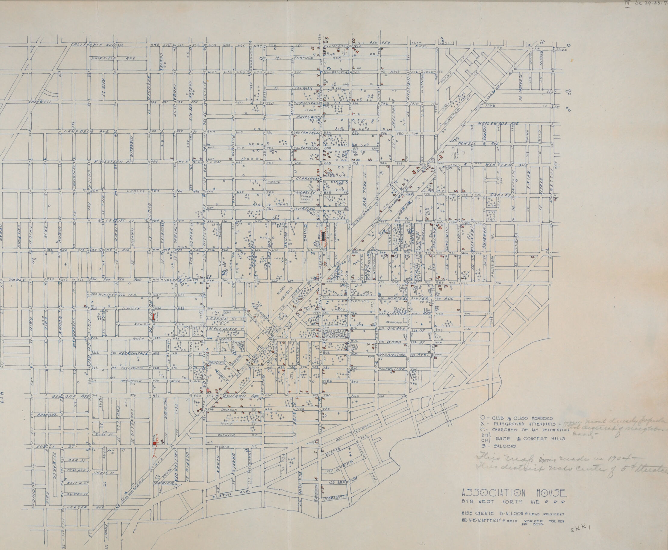
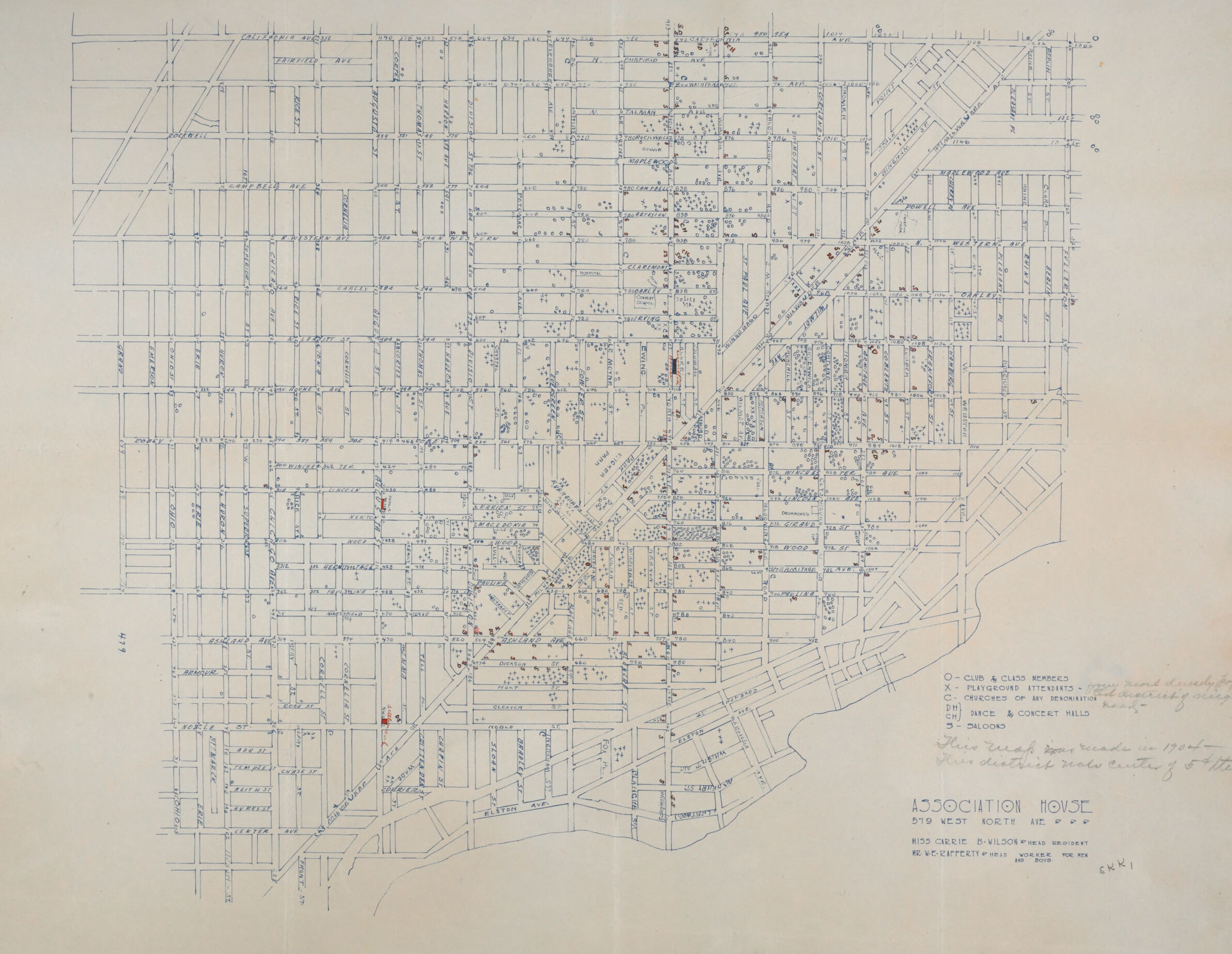
This image depicts a vintage, detailed map of a portion of an urban neighborhood. The map outlines a grid of streets, intersecting roads, and structures. Various symbols are annotated on the map, marking specific locations such as clubs, recreational spaces, churches, concert halls, and schools. A legend in the lower right corner explains the meaning of these symbols, providing context for the annotations. The map also includes handwritten notes, such as observations or clarifications, suggesting it may have been actively used for planning or analysis.
In the bottom-right corner, text identifies the organization responsible for the map as "Association House," located at "919 West North Ave." Additional details about personnel associated with the document are listed below. The map appears to reflect civic and community-oriented efforts, likely depicting urban resource allocation or demographic research in the mid-20th century. Subtle signs of aging are evident, such as faded edges and slight discoloration.
Created by gpt-4o-2024-08-06 on 2025-06-07
The image is a detailed street map highlighting the area around Wicker Park in Chicago, Illinois. The streets are outlined in a grid pattern with street names labeled. A key is provided in the lower right corner indicating various symbols:
- A circle with "o" marking "Club & Club Members"
- A triangle with "x" marking "Playground Interests"
- A plus sign marking "Churches or by Denomination"
- A square marking "Dance & Concert Halls"
- A star marking "Saloons"
- A red mark indicating "Delinquent Boys reached in 1903"
The map also includes the name "Association House" along with an address (919 West North Ave) and several names, likely coordinating individuals or organizations related to the annotations on the map. Additionally, there's a note specifying the categories denoted by the symbols, such as "Neighborhood Demography" and "The Association House Planning Strategy".
Overall, this map appears to have been used for social or community planning, marked with historical and social data points relevant to the Wicker Park area in the early 20th century.
Anthropic Claude
Created by anthropic.claude-3-haiku-20240307-v1:0 on 2025-06-12
This image appears to be a detailed map or blueprint of a city or urban area. It shows a grid-like layout of streets, blocks, and buildings, with various annotations and symbols indicating different types of structures or features. The map appears to be from an organization called "Association House" and includes some additional information about the area, such as the location of parks, concrete halls, and other landmarks. Overall, the image provides a comprehensive view of the urban layout and infrastructure of this particular location.
Created by us.anthropic.claude-3-opus-20240229-v1:0 on 2025-06-12
The image shows a detailed street map or plan of an area, likely a neighborhood or district. The map is hand-drawn in pencil or ink on gridded paper. It depicts a dense network of streets, blocks, and lots laid out in a grid pattern.
The map includes numerous annotations and labels, though the resolution makes them difficult to read clearly. There are measurements and dimensions marked along some of the streets and blocks. A scale is provided at the bottom right corner.
Based on the level of detail and the drafting style, this appears to be an urban planning or surveying document, perhaps an early proposal or sketch for laying out or subdividing this area for development. The dense, regular grid suggests an orderly planned layout typical of many towns and cities.
Created by us.anthropic.claude-3-5-sonnet-20241022-v2:0 on 2025-06-12
This is a detailed street map or city plan, drawn in blue lines on a light background. It appears to be for an "Association House" located at what seems to be a Chicago address. The map shows a grid pattern of streets typical of urban planning, with one major diagonal avenue cutting across the grid. Various dots and symbols are scattered throughout the map, with a legend indicating they represent different types of establishments or points of interest. The drawing has a professional, architectural quality to it and includes street names and other annotations. The map covers what appears to be several city blocks and provides a comprehensive view of the urban layout in this particular area.
Meta Llama
Created by us.meta.llama3-2-90b-instruct-v1:0 on 2025-05-25
The image presents a map of a neighborhood, likely from the early 20th century, with a focus on the layout and features of the area. The map is drawn in blue ink on a beige background, providing a clear visual representation of the neighborhood's structure.
Key Features:
- Grid Pattern: The map features a grid pattern, with streets running north-south and east-west, creating a series of rectangular blocks.
- Building Locations: Small red dots indicate the locations of buildings, providing insight into the density and distribution of structures within the neighborhood.
- Street Names: Some street names are visible, although they are not clearly legible, adding to the map's historical charm.
- Handwritten Notes: Handwritten notes in the bottom-right corner provide additional information about the map, including the name "Association House" and an address.
- Faded Ink: The ink used to create the map has faded over time, giving the image a soft, aged appearance.
Overall Impression:
The map offers a unique glimpse into the past, showcasing the layout and characteristics of a neighborhood from a bygone era. The combination of the grid pattern, building locations, and handwritten notes creates a rich and informative visual representation of the area.
Created by us.meta.llama3-2-11b-instruct-v1:0 on 2025-05-25
The image depicts a hand-drawn map of an area, likely created for planning or architectural purposes. The map is drawn on a beige background with blue lines and text, and features a grid pattern with various symbols and markings.
Map Features:
- Grid pattern: The map is divided into a grid of squares, with each square representing a specific area or plot of land.
- Symbols: Various symbols are used throughout the map to represent different features, such as buildings, roads, and parks.
- Text: The map includes handwritten text in the bottom-right corner, which appears to be a key or legend explaining the symbols and markings used on the map.
Background:
- Beige color: The background of the map is a light beige color, which provides a neutral and subtle contrast to the blue lines and text.
- Texture: The paper has a slight texture, giving it a slightly rough appearance.
Overall:
- The map appears to be a detailed and accurate representation of the area, with careful attention paid to the layout and features of the land.
- The use of symbols and text adds an extra layer of information and context to the map, making it a useful tool for planning and navigation.
Amazon Nova
Created by amazon.nova-pro-v1:0 on 2025-05-25
The image is a detailed map of a city, specifically focusing on the locations of various clubs and organizations. The map is divided into a grid with streets and avenues clearly marked. Each intersection is labeled with street names, and the grid is numbered for precise location identification.
Several red dots are scattered across the map, indicating the locations of clubs and organizations. These dots are likely marked to represent the presence of specific entities such as clubs, churches, and concert halls.
In the bottom right corner of the map, there is a section labeled "ASSOCIATION HOUSE," which is noted to be located at 519 West North Avenue. This section also includes additional information about the association and its purpose.
The map appears to be from an older era, possibly early to mid-20th century, based on the style and the types of organizations mentioned. The layout suggests a dense urban area with a well-established infrastructure.
The map is a valuable resource for understanding the geographical distribution of social and cultural organizations within the city, providing insights into the community's structure and the locations of significant social hubs.
Created by amazon.nova-lite-v1:0 on 2025-05-25
This image is a vintage map of the city of Chicago, Illinois, printed on a white background. The map is divided into several sections, with the main focus being the downtown area. The map features a grid-like pattern, with streets and buildings depicted in blue and red lines. The map also includes a legend in the bottom right corner, which explains the different symbols used on the map. In the top left corner, there is a handwritten note that reads "Association House" and "Miss Carrie D. Wilson."
Google Gemini
Created by gemini-2.0-flash on 2025-04-29
The image appears to be a hand-drawn map of a neighborhood, possibly a section of a city. The layout shows a grid pattern of streets and avenues, with names and sometimes numbers written along them. The map seems to be focusing on the location of specific types of establishments or community features, as indicated by a key on the lower right. These features are marked with symbols on the map itself, with red dots indicating the concentration or presence of these establishments.
The key includes labels such as:
- "O - CLUB & CLASS MEMBERS"
- "X - PLAYGROUND ATTENDANTS"
- "C - CHURCHES OF MY DENOMINATION"
- "PH - HALLS & CONCERT HALLS"
- "S - SALOONS"
Additionally, there are handwritten notes: "Here walk reade in 1900 - Thies district notes center of 54th teated."
The map is labeled "ASSOCIATION HOUSE, 519 WEST NORTH AVE", and includes the name "8155 CIRRIE B-VILDOST HEAD RESIDENT" and other information at the bottom. The map is detailed, with many individual building plots and numbered addresses along the streets.
Created by gemini-2.0-flash-lite on 2025-04-29
Here's a description of the image:
Overview:
The image is a detailed map, likely a historical one, depicting a city layout. It's drawn with blue lines, showing streets, and has various symbols marked in red, indicating points of interest.
Key Features and Elements:
- City Grid: The most prominent feature is the grid-like structure of the city streets, with numerous intersecting roads and avenues. Street names are labeled along the sides.
- Symbols and Markings: Red dots or symbols are scattered throughout the map. A legend in the lower right corner explains the meaning of some of these symbols:
- O: Club & Class Members
- X: Playground Attendants
- C: Churches Of My Denomination
- PH: Dance & Concert Halls
- S: Saloons
- Legend and Annotations: There are also annotations. A handwritten note states: "Hero ruch prica made in 1900. Then districts note center of the streat."
- Organization Information: At the bottom of the map, there's a heading "ASSOCIATION MOVSE 519 WEST NORTH A" with some additional text. It also includes details about the creator, "8155 CIRRIE B-VILDOST, and a signature of CKKI.
Possible Interpretation:
The map seems to be a social or demographic survey. The red symbols likely mark the locations of various community institutions (clubs, churches, dance halls, etc.), and it may have been created by the association house to map their area.
Mistral Pixtral
Created by us.mistral.pixtral-large-2502-v1:0 on 2025-05-25
The image appears to be a detailed architectural or urban planning map. Here is a detailed summary:
Layout and Design:
- The map shows a grid-like structure, indicating a planned urban area with streets and blocks.
- The streets are marked with lines, and the blocks are outlined, creating a clear grid pattern.
- There are various annotations and markings in blue and red ink, possibly indicating different types of data or changes.
Annotations:
- There are handwritten notes and annotations in the bottom right corner.
- The notes include:
- "2 copies & 1 set prints."
- "1. Plan and Typed Description."
- "2. 3 Prints of My Description."
- "3. 2 Prints of My Typed Description."
- "4. Blocks."
- "These tracks were made in 1926."
- "The others were made in the year 1927."
- There is also a title or label that reads "ASSOCIATION HOUSE" followed by an address: "519 WEST 40TH ST. N.Y."
- Additional information includes "RED CHALK DAVISON-WILLIAMS BROS. INC. ARCHITECTS" and a date "JAN. 24, 1927."
Map Details:
- The map includes street names and block numbers, providing a detailed layout of the area.
- Specific locations or points of interest might be marked with red dots or other symbols.
- The map seems to focus on a specific area, possibly a neighborhood or district within a city.
Purpose:
- The map appears to be used for urban planning, architectural design, or real estate purposes.
- The annotations suggest it was part of a project involving multiple copies and descriptions, possibly for distribution or presentation.
Overall, the image is a detailed urban planning map with specific annotations and markings, likely used for architectural or real estate purposes in the late 1920s.
Qwen
Created by Qwen/Qwen2.5-VL-7B-Instruct on 2025-07-28
This image is a historical map of a district, likely from the early 20th century, given the style of the handwriting and the notation that the map was made in 1904. The map is labeled "ASSOCIATION HOUSE" at the bottom and includes the address "519 West North Ave," suggesting it was related to or created by the Association House located at that address.
The map is detailed, showing a grid of streets with various names such as California Avenue, Roosevelt Street, Milwaukee Avenue, and others. There are numerous street names and numbered blocks, indicating a precise urban grid layout. The map also includes handwritten notes and symbols, some of which are explained in a legend on the right side. Symbols include:
- O - Club and class members
- X - Playground attendants
- C - Churches of any denomination
- DH - Dance & concert halls
- S - Saloons
These symbols seem to identify different types of locations or activities within the district. The map also notes that this district was the center of old theater activity, suggesting it was a bustling urban area with various entertainment and social hubs.
The map appears to be a resource for understanding the social and cultural landscape of this area in 1904, possibly for planning purposes or documenting the local community.
Created by Qwen/Qwen2.5-VL-72B-Instruct on 2025-07-28
This image is a detailed hand-drawn map of a neighborhood, likely from the early 20th century, based on the annotations and the style of the map. The map is marked with various symbols and includes a legend at the bottom right corner explaining the symbols:
- Circles with a dot in the center represent "Club & Class Members."
- Crosses (X) represent "Playground Attendants."
- C's represent "Churches of Any Denomination."
- DH's represent "Dance & Concert Halls."
- S's represent "Saloons."
The map is labeled "ASSOCIATION HOUSE" at the bottom right corner, with the address "519 WEST NORTH AVE" mentioned. It also notes "MISS CARRIE B. WILSON HEAD RESIDENT" and "MR. W.E. RAFFERTY HEAD WORKER FOR MEN AND BOYS."
The map includes street names such as California Ave, Fairfield Ave, Campbell Ave, Western Ave, Oakley Ave, and several others. There are also annotations in red ink, possibly highlighting specific areas or features. The map covers a grid of streets and blocks, with buildings and other structures marked.
The map appears to be a tool for social work or community organization, tracking various community resources and activities in the neighborhood. The annotations and symbols suggest it was used to identify and locate different types of community services and establishments.
Text analysis
Amazon