Machine Generated Data
Tags
Color Analysis
Feature analysis
Amazon
Clarifai

Clarifai
| Picture frame | 88.2% | |


Categories
Imagga
created on 2019-11-01
| nature landscape | 47.9% | |
| paintings art | 18.3% | |
| streetview architecture | 16.6% | |
| beaches seaside | 11.8% | |
| pets animals | 3.7% | |
Captions
Microsoft
created by unknown on 2019-11-01
| a vintage photo of a person | 56% | |
| a vintage photo of a person | 52% | |
| a vintage photo of some text | 51.9% | |
Clarifai
Created by general-english-image-caption-clip on 2025-07-11
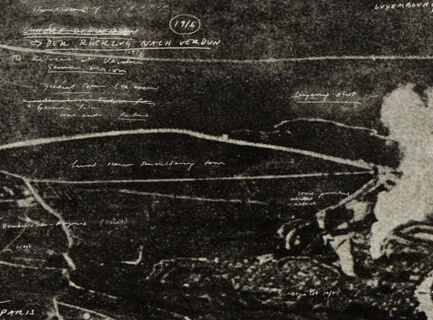
a map of the battle.
Salesforce
Created by general-english-image-caption-blip on 2025-05-05
a photograph of a black and white photograph of a train engine
OpenAI GPT
Created by gpt-4 on 2025-01-31
This image appears to be a black and white print depicting an aerial view or a map-like representation of a landscape, possibly an urban area due to the structured patterns that resemble streets and buildings. There are several annotations across the image in what seems to be white or light-colored handwriting, indicating various features or observations about the area shown in the print. There are also several smoke-like marks that could indicate smoke plumes or clouds. The nature of the annotations and structure suggests this could be a historical or military-related image, possibly connected to an event like a battle or a strategic planning map, but without further context, it's difficult to provide a precise explanation of the image's content.
Created by gpt-4o-2024-05-13 on 2025-01-31
The image is a black and white photograph that appears to be an aerial view of a landscape, possibly taken during a historical military reconnaissance mission. The photograph shows a terrain with various markings and annotations written directly onto the image. Some of the annotations label specific locations or features in the landscape.
The landscape features winding roads, fields, and areas that seem to be urban or developed. There is a prominent white plume of smoke or cloud near the center-right, suggesting some form of explosion, fire, or industrial activity in that area. The photo is somewhat grainy, indicating it might be from an older period, perhaps World War I or World War II.
The top left of the image has handwritten notes and what appears to be a circled date "1916". These notes are written in a cursive style and are somewhat difficult to decipher. Other parts of the image contain more handwriting, with labels pointing to specific areas within the photo, providing context or identifying points of interest.
Overall, the image seems to capture a significant or strategic area from above, with detailed notations that likely serve to map out or explain the relevance of different parts of the landscape.
Anthropic Claude
Created by us.anthropic.claude-3-5-sonnet-20241022-v2:0 on 2025-06-25
This appears to be a historical aerial reconnaissance photograph, likely from a military operation. The image is in black and white and shows a landscape view from above with various roads, pathways, and what appears to be military positions or installations marked on it. There's a notable plume of smoke or explosion visible in the center of the image, appearing as a white cloud against the darker background. The photograph has various annotations and markings written on it, suggesting it was used for military planning or documentation purposes. The terrain appears to be rural or semi-developed, with visible road networks intersecting throughout the frame. The quality and style of the photograph suggests it may be from one of the World Wars.
Created by claude-3-5-sonnet-20241022 on 2025-01-31
This appears to be a black and white aerial photograph or reconnaissance image, likely from a military context. It shows a landscape view from above with various roads, pathways and structures visible. There's a notable plume of smoke or explosion visible in the image, appearing as a light-colored cloud against the darker background. The image has various annotations and markings written on it, suggesting it may have been used for military planning or documentation purposes. The terrain appears to show both developed areas with structures as well as more open spaces, with winding roads connecting different sections. The overall quality and style of the photograph suggests it may be from a historical context, possibly from one of the World Wars.
Created by claude-3-opus-20240229 on 2025-01-31
The image appears to be a black and white aerial photograph or map showing an area with various labeled roads, trails and landmarks. The labels include names like "Brecksville Road", "Furnace Run", "Old Post Road", among others. In the center of the photograph, there is a large cloud of white smoke or vapor rising from the ground, likely indicating some major event or disturbance occurring at that location. The roads and trails seem to converge or lead towards the area where the smoke is emanating from. The overall scene has a dark, shadowy quality to it, giving it an ominous or mysterious atmosphere.
Created by claude-3-haiku-20240307 on 2025-01-31
The image appears to be an aerial photograph or map of a landscape during what seems to be a military or wartime event. The scene shows smoke plumes rising from various locations, suggesting the occurrence of explosions or fires. The landscape features a network of roads and railways, as well as what appear to be buildings and other structures. The overall image conveys a sense of devastation and conflict.
Meta Llama
Created by us.meta.llama3-2-11b-instruct-v1:0 on 2025-03-11
The image is a black and white aerial photograph of an area with a river, roads, and buildings. The photograph appears to be from the early 20th century, possibly during World War I.
- The photograph is taken from an aerial perspective, showing the landscape in a bird's-eye view.
- The image is in black and white, which was common for aerial photographs during this time period.
- The photograph shows a river running through the center of the image, with roads and buildings along its banks.
- There are several buildings and structures visible in the image, including what appears to be a factory or industrial site.
- The photograph also shows several roads and highways, which were likely important for transportation and communication during this time period.
- The image has a sepia tone, which gives it a vintage or antique look.
- The photograph is surrounded by a white border, which helps to frame the image and make it easier to view.
Overall, the image provides a unique glimpse into the landscape and infrastructure of an area during a specific time period. It could be useful for historians, researchers, or anyone interested in learning more about the past.
Created by us.meta.llama3-2-90b-instruct-v1:0 on 2025-03-11
The image is a black-and-white photograph of a map, with handwritten notes and markings. The map appears to be a topographical map, showing roads, rivers, and other geographical features. The handwritten notes are in white ink and appear to be in a foreign language, possibly German or French. The notes are scattered throughout the map, with some appearing to be labels for specific locations or features, while others appear to be notes or comments about the map itself. The overall effect of the image is one of age and wear, with the map appearing to be old and faded, and the handwritten notes adding a sense of authenticity and historical significance.
Amazon Nova
Created by amazon.nova-pro-v1:0 on 2025-01-31
The image is a black-and-white photograph of an aerial view of a landscape. It shows a river running through the middle of the image. There are buildings and structures on either side of the river, and the landscape is surrounded by trees and vegetation. The sky is clear, and there are no clouds visible. The image has a vintage look and feel, and it appears to be a historical photograph.
Created by amazon.nova-lite-v1:0 on 2025-01-31
The image is a black-and-white photograph of a historical map or diagram. The map shows a landscape with various markings and annotations in a foreign language, possibly German. The central focus of the image is a large, circular structure with a plume of smoke rising from it, indicating an active or recently active site. The map includes several other structures, paths, and annotations that provide context to the central feature. The photograph is framed by a white border, enhancing its presentation as an art piece or historical document.
Google Gemini
Created by gemini-2.0-flash-lite on 2025-05-05
Here's a description of the image:
The image is a monochrome, perhaps a grayscale print, resembling an aerial view of a landscape. It's likely a map or a depiction of a specific geographical area. Several handwritten annotations are scattered across the image, suggesting the artist's notes or a commentary on the depicted scene.
Key elements include:
- Topography: The image shows a terrain with apparent roads, rivers, and what seem like structures. The landscape appears to have some texture, maybe due to the way the print was made.
- Annotations: The handwritten notes are in a script, and are located at various points across the image. These notes are a critical element.
- Composition: The image is framed by a white border, which emphasizes its presentation as an artwork.
Overall, the image conveys a sense of history, documentation, and personal interpretation, as seen through an artist's eye.
Created by gemini-2.0-flash on 2025-05-05
The image shows a black and white aerial photograph, likely from a historical context, overlaid with handwritten annotations. The photograph depicts a landscape with fields, roads, and a body of water, possibly a river. There is a large plume of smoke rising from a central location, suggesting an explosion or fire.
The annotations appear to be in both German and English, indicating place names, directions, or descriptive comments. Some of the legible words include "Luxembourg," "Paris," and "nach Verdun." The annotations are scattered across the image, seemingly pointing out specific features or areas of interest within the landscape.
The overall impression is that of a military reconnaissance image from a conflict, possibly World War I or World War II. The annotations suggest that the photograph was being used for strategic or informational purposes, with key locations and events being marked for reference.
Mistral Pixtral
Created by us.mistral.pixtral-large-2502-v1:0 on 2025-06-07
The image appears to be a historical aerial photograph, likely from World War I, depicting a battlefield or war-torn area. Here are the key details:
Title and Date: The image is labeled "1916" in the upper left corner, indicating the year it was taken.
Geographical Features: The photograph shows various landmarks and areas, with labels written in a language that appears to be German. Some of the labeled places include:
- "Mesnil-les-Hurlus"
- "Souain"
- "Perthes"
- "Tahure"
- "Massiges"
- "Minaucourt"
- "Wacogne"
- "Auberive"
War Damage: The image shows significant signs of destruction, with large areas of smoke and what appears to be bomb craters or heavily damaged terrain. The smoke suggests recent bombardments or ongoing fires.
Trenches and Military Positions: The photograph includes lines and markings that likely represent trenches and military positions, indicating the layout of the battlefield.
Roads and Paths: Various roads and paths are visible, connecting different areas and providing a sense of the landscape's infrastructure.
Forest and Vegetation: There are areas marked with dense vegetation or forested regions, such as "Bois de la Grurie" and "Bois de Ville-sur-Tourbe."
Overall, the image provides a detailed aerial view of a battlefield during World War I, showing the extent of destruction and the strategic layout of military positions and infrastructure.
Qwen
No captions written
Text analysis
Amazon