Machine Generated Data
Tags
Color Analysis
Feature analysis
Amazon
Clarifai
AWS Rekognition
| Passport | 95.2% | |

Categories
Imagga
created on 2022-01-08
| paintings art | 100% | |
Captions
Microsoft
created by unknown on 2022-01-08
| map | 98.8% | |
Clarifai
Created by general-english-image-caption-clip on 2025-07-12
a map of the city.
Salesforce
Created by general-english-image-caption-blip on 2025-05-03
a photograph of a map of a city with a map of a city
OpenAI GPT
Created by gpt-4 on 2024-12-22
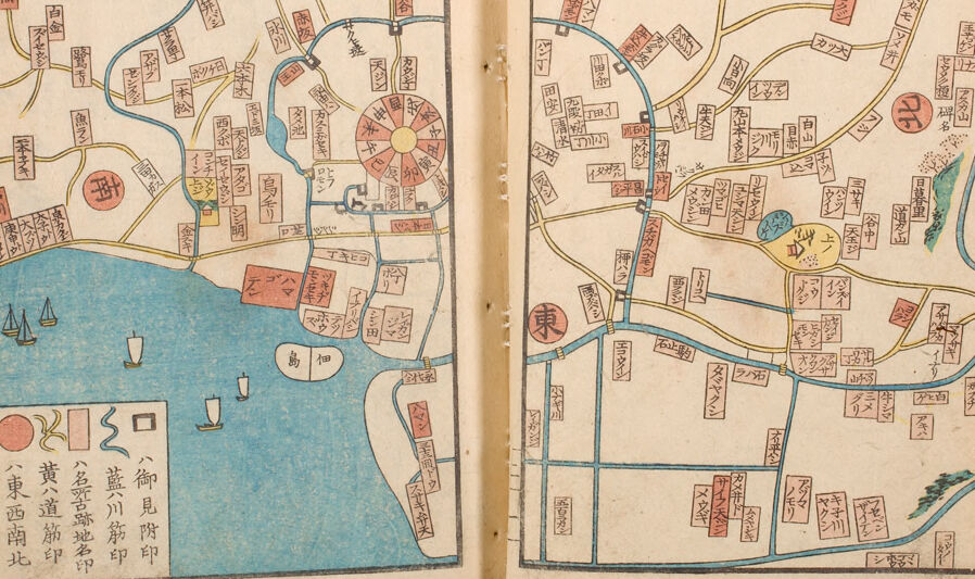
The image appears to be an antique map that is spread across two pages of an open book. The map is intricately detailed and hand-colored, suggesting that it might be a very old or historical document. The styling and the characters on the map suggest that it is of Asian origin, possibly a Japanese map due to the script that looks like Japanese kanji.
On the left side, there is a blue body of water with several sailing ships depicted, and the shoreline curves around with several buildings drawn in a stylized manner. There are various sections and paths marked out in different colors, which may indicate different districts or types of roads. A segment of the town is laid out in a circular pattern, suggesting a planned urban area, possibly a castle town with a central structure.
On the right side, the map continues with a similar pattern of roads and buildings. There are trees and possibly hills or mountains illustrated, indicating the geography of the area. Streams or rivers are colored in blue, snaking through the landscape, connecting with the body of water depicted on the left page.
Altogether, the map seems to represent a specific city or region, with attention to geographical features and infrastructure. It is rich in cultural and historical information and could be very valuable for researches looking into the area's past urban development and topography.
Created by gpt-4o-2024-05-13 on 2024-12-22
This image depicts a colorful, historical Japanese woodblock print map. The map spans two pages of an open book. It illustrates an urban area, likely a city or town, characterized by a network of roads, waterways, and buildings.
On the left page, there is a body of water represented in blue, possibly a harbor or river, with illustrations of sailing boats. There are various symbols and labels written in Japanese kanji characters along the roads and areas. Key landmarks or districts are marked in distinct, often rectangular blocks shaded in different colors such as red, yellow, green, and blue.
A circular area could represent a significant central plaza or market. The right page continues this urban layout, displaying more neighborhoods annotated with Japanese characters and delineated by roads of varying thickness.
The detailed and compact nature of the map, along with the style of the illustrations, suggests it is from an earlier period, capturing the layout and key features of the city for navigation or informational purposes.
Anthropic Claude
Created by us.anthropic.claude-3-5-sonnet-20241022-v2:0 on 2025-06-28
This appears to be a historical Japanese map spread across two pages. The left page shows a coastal area with a body of water (colored in blue) where several boats or ships are illustrated. There are various Japanese characters and text boxes scattered throughout both pages, likely indicating place names and locations. The map uses a simple color scheme of blue, red, yellow, and black ink on what appears to be aged paper.
The map includes various paths or roads shown as lines connecting different areas, and there's a circular design element on the left page that could represent a significant landmark or administrative center. In the bottom left corner, there's a legend or key with different symbols and colors explained in Japanese characters.
The right page continues the map inland, showing more paths, districts, and labeled areas. There are some green elements that might represent vegetation or parks. The overall style is typical of Edo period Japanese cartography, with a mix of practical geographic information and artistic elements.
Created by claude-3-haiku-20240307 on 2024-12-22
This image appears to be an old, handwritten map of a town or city. It contains various roads, landmarks, and labels written in what appears to be an East Asian language, likely Japanese or Chinese. The map is divided into two pages, with a body of water, possibly a river or lake, visible on the left side. The overall style and visual elements suggest this is a historical or traditional map, rather than a modern cartographic representation.
Created by claude-3-5-sonnet-20241022 on 2024-12-22
This appears to be a historical Japanese map spread across two pages. The left page shows a coastal area with water (colored in blue) and several sailing vessels illustrated. There's a circular design that could represent a significant landmark or structure. Various Japanese characters and text boxes are scattered throughout both pages, likely indicating place names and locations. The paths or roads are marked in yellow and blue lines that branch out across both pages, creating a network of routes. In the bottom left corner, there's a legend or key with different symbols and colors. The right page continues the map inland, showing more text labels and pathways. The overall style is typical of traditional Japanese cartography, with a mix of practical geographic information and artistic elements. The paper appears aged, giving it a historical document feel.
Meta Llama
Created by us.meta.llama3-2-11b-instruct-v1:0 on 2024-12-22
The image presents a vintage map of a city, likely from the 19th or early 20th century, with a focus on its layout and features. The map is rendered in a traditional style, characterized by hand-drawn illustrations and Chinese characters.
- Map Layout:
- The map is divided into two pages, with the left page featuring a larger section of the city and the right page showing a smaller area.
- The map's orientation is oriented with north at the top, as indicated by the compass rose in the bottom-left corner of the left page.
- City Features:
- The city is depicted with various landmarks, including rivers, roads, buildings, and parks.
- The map includes symbols for different types of buildings, such as temples, schools, and government offices.
- The city's layout appears to be organized around a central axis, with major roads and landmarks radiating from the center.
- Chinese Characters:
- The map is written in Chinese characters, which provide additional information about the city's features and landmarks.
- The characters are used to label different areas of the city, including streets, buildings, and parks.
- Some characters appear to be place names or titles, while others may indicate the type of building or feature depicted on the map.
- Color Scheme:
- The map features a muted color scheme, with shades of blue, red, yellow, and black used to depict different features.
- The colors are used to create visual contrast and make it easier to distinguish between different elements on the map.
- Condition:
- The map appears to be in good condition, with minimal signs of wear or damage.
- The paper is yellowed and slightly worn, but the ink is still clear and legible.
- The map is likely a rare and valuable artifact, providing insight into the history and culture of the city it depicts.
In summary, the image presents a detailed and colorful map of a city, likely from the 19th or early 20th century. The map is written in Chinese characters and features a range of landmarks and features, including rivers, roads, buildings, and parks. The map's layout and color scheme are well-suited to its purpose, making it easy to navigate and understand. Overall, the map provides a unique glimpse into the history and culture of the city it depicts.
Created by us.meta.llama3-2-90b-instruct-v1:0 on 2024-12-22
The image presents an open book with two pages, each featuring a map. The maps are rendered in a traditional Japanese style, characterized by a beige background and adorned with various symbols, markings, and Chinese characters.
Map Features:
- Waterways: Blue lines represent rivers or canals, while yellow lines signify roads or paths.
- Symbols and Markings: Red circles, rectangles, and other shapes are scattered throughout the maps, likely indicating important locations or landmarks.
- Chinese Characters: Written in black ink, these characters provide additional information about the areas depicted on the maps.
Book Details:
- Binding: The book appears to be bound with a simple stitch or glue, as evidenced by the visible thread or adhesive along the spine.
- Page Condition: The pages show signs of aging, with yellowing paper and slight wear around the edges.
Overall Impression:
The image suggests that the book is an antique or vintage volume, possibly from Japan or another East Asian country. The maps may be historical records of urban planning, trade routes, or cultural significance.
Amazon Nova
Created by amazon.nova-lite-v1:0 on 2025-02-28
The image shows an open book with two pages displaying detailed maps of a city. The maps are printed on both sides of the pages, with the left page showing a map of the city's central area, including landmarks and streets, and the right page showing a map of the surrounding areas. The maps are printed in black, blue, and red ink, with red and blue lines indicating roads and waterways. The maps are accompanied by Japanese text, which may provide additional information about the city's layout and landmarks.
Created by amazon.nova-pro-v1:0 on 2025-02-28
The image is of an open book with two pages that contain a map. The book is open to the pages with the map. The map is of a city, and it has various features and landmarks marked on it. The map is divided into two sections, with the left section showing the city's layout and the right section showing the surrounding area. The map is in black and white, with some colored markings.
Google Gemini
Created by gemini-2.0-flash-lite on 2025-05-09
Here's a description of the image:
The image shows an open book with two facing pages. Each page contains a detailed, hand-drawn map in a style reminiscent of traditional Japanese cartography. The maps use a combination of lines, symbols, and text (presumably Japanese) to depict various locations, roads, bodies of water, and potentially landmarks.
Key elements of the maps include:
- Layout: The maps appear to represent a city or region. There are interconnected roads, rivers or canals, and what may be coastlines or shorelines.
- Colors: The maps utilize a limited color palette, with colors such as blue for water bodies, red for perhaps important locations or markers, and yellow for land areas or roads. The use of color is typical of the aesthetic of the period.
- Symbols and Text: Numerous small icons, symbols, and Japanese characters are used to label locations, features, and potentially provide context. The text is written vertically, and there is a combination of place names and potentially descriptive words.
- Decorative Elements: Some decorative elements, such as shaded areas and stylized representations of features, add visual interest.
The style suggests that the map may be a historical artifact or a reproduction of one. Overall, the image conveys a sense of history and traditional artistic skill.
Created by gemini-2.0-flash on 2025-05-09
Here's a description of the image based on the provided information:
The image shows an open book displaying a map spread across two pages. The book is old, with off-white, slightly aged paper. The edges of the pages show minor wear and tear.
The maps themselves are detailed and appear to be from an East Asian origin, likely Japanese given the writing style. They are colorful, employing a limited palette of blue, red, yellow, and beige. Roads and waterways are depicted with blue lines. Different landmarks and areas are labeled with vertical kanji characters.
The left page includes a coastal area with boats. The right page is mostly land. The map appears to depict a specific region, perhaps a city and its surrounding area, with various districts, rivers, and geographical features marked. The overall impression is that of a historical or antique document, carefully preserved.
Mistral Pixtral
Created by us.mistral.pixtral-large-2502-v1:0 on 2025-06-02
The image depicts a historical map from Japan, likely from the Edo period. The map is a detailed illustration of a city, with various landmarks, streets, and waterways clearly marked. Here are some key features of the map:
Layout and Design: The map is divided into two pages, each showing different sections of the city. The layout includes a network of streets and paths, with buildings and landmarks represented by rectangular shapes.
Labels and Text: The map is annotated with Japanese characters, indicating the names of streets, buildings, and other significant locations. These labels are written in a traditional script, which is typical of historical Japanese maps.
Water Bodies: There are blue areas representing bodies of water, such as rivers or canals, which are integral to the city's layout. These waterways are likely used for transportation and commerce.
Landmarks: Several prominent landmarks are marked on the map, including what appears to be a large circular structure, possibly a castle or a significant public building. Other notable buildings are also highlighted with distinct shapes and colors.
Symbols and Icons: The map uses various symbols and icons to represent different types of structures and features. For example, there are symbols for bridges, temples, and other important sites.
Color Coding: The map uses a limited color palette, with blue for water, red for certain landmarks, and yellow or brown for streets and buildings. This color coding helps to differentiate between various features and makes the map easier to read.
Artistic Style: The map has an artistic and somewhat stylized appearance, which is characteristic of traditional Japanese cartography. The illustrations are detailed but also have a decorative quality.
Overall, this map provides a detailed and visually appealing representation of a historical Japanese city, offering insights into its urban planning, significant landmarks, and the role of waterways in its infrastructure.
Qwen
Created by Qwen/Qwen2.5-VL-7B-Instruct on 2025-07-24
This image shows an open book with two facing pages, each featuring a detailed map with various markings and labels. The maps appear to be of an area with a focus on water bodies, as there is a prominent blue area representing water on the left page, with a depiction of boats on it. The right page has a different area with less water feature but still includes some water bodies. Both maps are rich in detail, with numerous labeled sections and areas that are likely to represent different zones or districts within the region. The text on the page is primarily in Japanese, with some characters written vertically and horizontally. The maps include a variety of symbols and markers, possibly indicating different types of terrain, landmarks, or points of interest. The pages show signs of aging, with some visible wear and discoloration.
Created by Qwen/Qwen2.5-VL-72B-Instruct on 2025-07-24
The image shows an open book with two pages that appear to be part of an old map. The map is drawn in a style that suggests it is from an East Asian country, likely Japan, given the characters and the style of the map.
Key features of the map include:
- Numerous labels written in what appears to be Japanese script.
- A prominent circular design in the center of the left page, which could be a compass or a decorative element.
- Blue lines that likely represent rivers or waterways.
- A large body of water on the left page with several boats depicted.
- Red and black rectangular shapes that may represent buildings or landmarks.
- A key or legend in the bottom left corner of the left page, which includes various symbols and text.
The map is detailed and appears to be a historical document, possibly used for navigation or administrative purposes.
Text analysis
Amazon